
Schist is a medium-grade metamorphic rock formed from mudstone or shale. Schist has medium to large, flat, sheet-like grains in a preferred orientation. It is defined by having more than 50% platy and elongated minerals, often finely interleaved with quartz and feldspar. These lamellar minerals include micas, chlorite, talc, hornblende, graphite, and others. Quartz often occurs in drawn-out grains to such an extent that a particular form called quartz schist is produced. Schist is often garnetiferous. Schist forms at a higher temperature and has larger grains than phyllite. Geological foliation with medium to large grained flakes in a preferred sheetlike orientation is called schistosity.

The Kitzbühel Alps are a mountain range of the Central Eastern Alps surrounding the town of Kitzbühel in Tyrol, Austria. Geologically they are part of the western slate zone.

The Tux Alps or Tux Prealps are a sub-group of the Austrian Central Alps, which in turn form part of the Eastern Alps within Central Europe. They are located entirely within the Austrian federal state of Tyrol. The Tux Alps are one of three mountain ranges that form an Alpine backdrop to the city of Innsbruck. Their highest peak is the Lizumer Reckner, 2,886 m (AA), which rises between the glen of Wattentaler Lizum and the valley of the Navisbach. Their name is derived from the village of Tux which is tucked away in a side valley of the Zillertal.

The Riss glaciation, Riss Glaciation, Riss ice age, Riss Ice Age, Riss glacial or Riss Glacial is the second youngest glaciation of the Pleistocene epoch in the traditional, quadripartite glacial classification of the Alps. The literature variously dates it to between about 300,000 to 130,000 years ago and 347,000 to 128,000 years ago. It coincides with the Saale glaciation of North Germany. The name goes back to Albrecht Penck and Eduard Brückner who named this cold period after the river Riss in Upper Swabia in their three-volume work Die Alpen im Eiszeitalter published between 1901 and 1909.

The Radstadt Tauern are a subrange of the Central Eastern Alps in Austria. Together with the Schladming Tauern, the Rottenmann and Wölz Tauern and the Seckau Tauern the Radstadt Tauern form the major range of mountains known as the Low Tauern. The mountains are found in the southeast of the Austrian state of Salzburg, between the upper reaches of the Enns and Mur rivers.

Lake Millstatt is a lake in Carinthia, Austria.
Alfred Rittmann was a leading volcanologist. He was elected President of the International Association of Volcanology for three terms (1954–1963).

Schinder is a mountain on the border of Bavaria, Germany and Tyrol, Austria. There are two summits, one called Austrian Schinder or Trausnitzberg, and the other slightly lower one called Bavarian Schinder. The former sits right on the border of Bavaria and Tyrol, whereas the latter is situated wholly in Bavaria.

The Blomberg is a mountain, 1,248 m high, in Bavaria, Germany and is the local mountain of Bad Tölz and a popular destination both with locals and visitors to the region. It is accessible on a short footpath which is steep in places or with the aid of a chairlift.

The Guffert is a 2,195 metres (7,201 ft) high, isolated, prominent limestone alpenstock in the Brandenberg Alps (Rofan) that, together with the Guffertstein, forms a twin peak. It lies north of Steinberg am Rofan. Because it projects above the Mangfall Mountains to the north by about 300 metres, the striking double peak is easily recognised from the Alpine Foreland, the Tegernsee and the Bavarian Prealps.

The Geißstein, sometimes also called the Gaisstein, is a mountain in the Kitzbühel Alps with a height of 2,366 m (AA) that straddles the border between the federal Austrian states of Tyrol and Salzburg

The North Bohemian Basin, in Czech called more often the Most Basin, is a landscape in North Bohemia. It forms the south-western and central parts of the Ústí nad Labem Region. It is among the richest European deposits of lignite, which has been extracted here since the second half of 19th century, mostly by extensive surface mining.
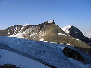
The Hinterer Bratschenkopf is a mountain in the Glockner Group on the Fusch-Kaprun ridge in the High Tauern, a high mountain range in the Austrian Central Alps. According to the listed sources it is 3,412 metres high, but the Austrian Federal Office for Metrology and Survey gives its height as 3,413 metres. The mountain lies in the Austrian state of Salzburg. It appears from the north, east and south as a gently curved firn summit, but from the west it has a mighty, 1,400-metre-high (4,600 ft) and 40 to 60° rock face. A steep, 500-metre-long (1,600 ft) knife-edge ridge bears away from the mountaintop to the north. Due to its close proximity to the Heinrich Schwaiger Haus, the summit is a popular viewing point. The peak was first climbed on 18 September 1869 by the Munich Alpinist, Karl Hofmann, the Prague businessman, Johann Stüdl, and mountain guides Thomas Groder and Josef Schnell from Kals am Großglockner.
The Lizumer Reckner is, at 2,886 m above sea level (AA), the highest mountain in the Tux Alps in the Austrian state of Tyrol.

The Schladming Tauern are a subrange of the Austrian Central Alps within the Eastern Alps. Together with the Radstadt Tauern, the Rottenmann and Wölz Tauern and the Seckau Tauern the Schladming Tauern form the major range known as the Low Tauern. The mountains are located in Austria in the federal states of Salzburg and Styria. Its highest peak, at 2,862 m is the Hochgolling.

The Rottenmann and Wölz Tauern are a subrange of the Austrian Central Alps within the Eastern Alps. Together with the Radstadt Tauern, the Schladming Tauern and the Seckau Tauern the Rottenmann and Wölz Tauern form the major range known as the Low Tauern. The mountains are located in Austria in the federal state of Styria.

The Seckau Tauern or Seckau Alps are a small subrange of the Low Tauern mountains in the Austrian Central Alps, part of the Eastern Alps. The range is located in the Austria state of Styria.
An alpentor in geology is the point where an entire glacier forced its way through to the Alpine Foreland from the Alps during the ice age.

A double summit, double peak, twin summit or twin peak refers to a mountain or hill that has two summits, separated by a col or saddle.
