Drunken trees

Last updated
A drunken forest in Siberia caused by melting permafrost 20070801 forest.jpg
A drunken forest in Siberia caused by melting permafrost

Drunken trees, tilted trees, or a drunken forest, is a stand of trees rotated from their normal vertical alignment. [1] [2]

Contents

This most commonly occurs in northern subarctic taiga forests of black spruce ( Picea mariana ) under which discontinuous permafrost or ice wedges have melted, [3] [4] causing trees to tilt at various angles. [5] [6]

Tilted trees may also be caused by frost heaving, [7] and subsequent palsa development, [8] hummocks, [9] earthflows, [10] [11] forested active rock glaciers, [12] landslides, or earthquakes. [13] In stands of spruce trees of equal age that germinated in the permafrost active layer after a fire, tilting begins when the trees are 50 to 100 years old, suggesting that surface heaving from new permafrost aggradation can also create drunken forests. [4]

Permafrost

Permafrost, which is soil (or rock) that remains below 0 °C for at least two consecutive years, [14] forms a solid matrix in soil which can extend to a depth of hundreds of meters. [15] The permafrost prevents trees from developing deep root systems; for example, the black spruce that has adapted to permafrost soils has no significant taproot. [16] In areas where the permafrost temperature is near the melting point of water, climate variations, or loss of surface vegetation from fire, flooding, construction, or deforestation, can thaw the upper extents of the permafrost, creating a thermokarst, [17] the scientific name for a ground slump caused by melting permafrost. [13] The thermokarst undermines the shallow root bed of these trees, causing them to lean or fall. [6] Thermokarst lakes are surrounded by a ring of drunken trees leaning toward the lake, which makes these land features easily identifiable. [18]

Drunken trees may eventually die from their displacement, [19] and in ice-rich permafrost, the entire drunken forest ecosystem can be destroyed by melting. [20] Tilted trees that do not topple over may recover by using gravitropism to resume vertical growth, thereby taking on a curved shape. [21] The reaction wood formed by this process can be studied using dendrochronology using annual growth rings to determine when the tree was subjected to tilting. [20] [22] [23]

Relationship to climate change

Drunken trees are not a completely new phenomenon—dendrochronological evidence can date thermokarst tilting back to at least the 19th century. [13] The southern extent of the subarctic permafrost reached a peak during the Little Ice Age of the 16th and 17th centuries, [24] and has been in decline since then. [25] [26]

Permafrost is typically in disequilibrium with climate, and much of the permafrost that remains is in a relict state. [19] [27] However, the rate of thawing has been increasing, [28] [29] [30] and a great deal of the remaining permafrost is expected to thaw during the 21st century. [31] [32]

Al Gore cited drunken trees caused by melting permafrost in Alaska as evidence of global warming, as part of his presentation in the 2006 documentary film An Inconvenient Truth . Similar warming leading to permafrost thawing in neighboring Siberia has been attributed to a combination of anthropogenic climate change, a cyclical atmospheric phenomenon known as the Arctic oscillation, and albedo positive feedbacks caused by both when melting ice exposes bare ground and ocean which absorb, rather than reflect, solar radiation. [33] [34]

See also

Related Research Articles

<span class="mw-page-title-main">Tundra</span> Biome where plant growth is hindered by frigid temperatures

In physical geography, tundra is a type of biome where tree growth is hindered by frigid temperatures and short growing seasons. The term is a Russian word adapted from Sámi languages. There are three regions and associated types of tundra: Arctic tundra, alpine tundra, and Antarctic tundra.

<span class="mw-page-title-main">Permafrost</span> Soil frozen for a duration of at least two years

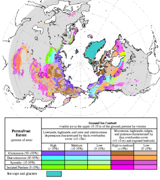
Permafrost is soil or underwater sediment which continuously remains below 0 °C (32 °F) for two years or more: the oldest permafrost had been continuously frozen for around 700,000 years. While the shallowest permafrost has a vertical extent of below a meter (3 ft), the deepest is greater than 1,500 m (4,900 ft). Similarly, the area of individual permafrost zones may be limited to narrow mountain summits or extend across vast Arctic regions. The ground beneath glaciers and ice sheets is not usually defined as permafrost, so on land, permafrost is generally located beneath a so-called active layer of soil which freezes and thaws depending on the season.

<span class="mw-page-title-main">Talik</span>

A talik is a layer of year-round unfrozen ground that lies in permafrost areas. In regions of continuous permafrost, taliks often occur underneath shallow thermokarst lakes and rivers, where the deep water does not freeze in winter and thus the soil underneath does not freeze either. Sometimes closed, open, and through taliks are distinguished. These terms refer to whether the talik is surrounded by permafrost, open at the top, or open both at the top and above an unfrozen layer beneath the permafrost.

<span class="mw-page-title-main">Thermokarst</span> Irregular land surface of marshy hollows and small hummocks formed as permafrost thaws

Thermokarst is a type of terrain characterised by very irregular surfaces of marshy hollows and small hummocks formed as ice-rich permafrost thaws. The land surface type occurs in Arctic areas, and on a smaller scale in mountainous areas such as the Himalayas and the Swiss Alps.

<span class="mw-page-title-main">Pingo</span> Mound of earth-covered ice

Pingos are intrapermafrost ice-cored hills, 3–70 m (10–230 ft) high and 30–1,000 m (98–3,281 ft) in diameter. They are typically conical in shape and grow and persist only in permafrost environments, such as the Arctic and subarctic. A pingo is a periglacial landform, which is defined as a non-glacial landform or process linked to colder climates. It is estimated that there are more than 11,000 pingos on Earth. The Tuktoyaktuk peninsula area has the greatest concentration of pingos in the world with a total of 1,350 pingos. There is currently remarkably limited data on pingos.

Yedoma is an organic-rich Pleistocene-age permafrost with ice content of 50–90% by volume. Yedoma are abundant in the cold regions of eastern Siberia, such as northern Yakutia, as well as in Alaska and the Yukon.

<span class="mw-page-title-main">Palsa</span> A low, often oval, frost heave occurring in polar and subpolar climates

Palsas are peat mounds with a permanently frozen peat and mineral soil core. They are a typical phenomenon in the polar and subpolar zone of discontinuous permafrost. One of their characteristics is having steep slopes that rise above the mire surface. This leads to the accumulation of large amounts of snow around them. The summits of the palsas are free of snow even in winter, because the wind carries the snow and deposits on the slopes and elsewhere on the flat mire surface. Palsas can be up to 150 m in diameter and can reach a height of 12 m.

<span class="mw-page-title-main">Arctic ecology</span> Study of the relationships between biotic and abiotic factors in the arctic

Arctic ecology is the scientific study of the relationships between biotic and abiotic factors in the arctic, the region north of the Arctic Circle. This region is characterized by two biomes: taiga and tundra. While the taiga has a more moderate climate and permits a diversity of both non-vascular and vascular plants, the tundra has a limited growing season and stressful growing conditions due to intense cold, low precipitation, and a lack of sunlight throughout the winter. Sensitive ecosystems exist throughout the Arctic region, which are being impacted dramatically by global warming.

<span class="mw-page-title-main">Climate change in the Arctic</span> Impacts of climate change on the Arctic

Major environmental issues caused by contemporary climate change in the Arctic region range from the well-known, such as the loss of sea ice or melting of the Greenland ice sheet, to more obscure, but deeply significant issues, such as permafrost thaw, as well as related social consequences for locals and the geopolitical ramifications of these changes. The Arctic is likely to be especially affected by climate change because of the high projected rate of regional warming and associated impacts. Temperature projections for the Arctic region were assessed in 2007: These suggested already averaged warming of about 2 °C to 9 °C by the year 2100. The range reflects different projections made by different climate models, run with different forcing scenarios. Radiative forcing is a measure of the effect of natural and human activities on the climate. Different forcing scenarios reflect things such as different projections of future human greenhouse gas emissions.

<span class="mw-page-title-main">Tipping points in the climate system</span> Large and possibly irreversible changes in the climate system

In climate science, a tipping point is a critical threshold that, when crossed, leads to large, accelerating and often irreversible changes in the climate system. If tipping points are crossed, they are likely to have severe impacts on human society and may accelerate global warming. Tipping behavior is found across the climate system, for example in ice sheets, mountain glaciers, circulation patterns in the ocean, in ecosystems, and the atmosphere. Examples of tipping points include thawing permafrost, which will release methane, a powerful greenhouse gas, or melting ice sheets and glaciers reducing Earth's albedo, which would warm the planet faster.

<span class="mw-page-title-main">Arctic methane emissions</span> Release of methane from seas and soils in permafrost regions of the Arctic

Arctic methane release is the release of methane from Arctic ocean waters as well as from soils in permafrost regions of the Arctic. While it is a long-term natural process, methane release is exacerbated by global warming. This results in a positive climate change feedback, as methane is a powerful greenhouse gas. The Arctic region is one of many natural sources of methane. Climate change could accelerate methane release in the Arctic, due to the release of methane from existing stores, and from methanogenesis in rotting biomass. When permafrost thaws as a consequence of warming, large amounts of organic material can become available for methanogenesis and may ultimately be released as methane.

<span class="mw-page-title-main">Sergey Zimov</span>

Sergey Aphanasievich Zimov is a Russian geophysicist who specialises in arctic and subarctic ecology. He is the Director of Northeast Scientific Station, a senior research fellow of the Pacific Institute for Geography, and one of the founders of Pleistocene Park. He is best known for his work in advocating the theory that human overhunting of large herbivores during the Pleistocene caused Siberia's grassland-steppe ecosystem to disappear and for raising awareness as to the important roles permafrost and thermokarst lakes play in the global carbon cycle.

<span class="mw-page-title-main">North American Arctic</span>

The North American Arctic is composed of the northern polar regions of Alaska (USA), Northern Canada and Greenland. Major bodies of water include the Arctic Ocean, Hudson Bay, the Gulf of Alaska and North Atlantic Ocean. The North American Arctic lies above the Arctic Circle. It is part of the Arctic, which is the northernmost region on Earth. The western limit is the Seward Peninsula and the Bering Strait. The southern limit is the Arctic Circle latitude of 66° 33’N, which is the approximate limit of the midnight sun and the polar night.

<span class="mw-page-title-main">Climate change feedbacks</span> Feedback related to climate change

Climate change feedbacks are effects of global warming that amplify or diminish the effect of forces that initially cause the warming. Positive feedbacks enhance global warming while negative feedbacks weaken it. Feedbacks are important in the understanding of climate change because they play an important part in determining the sensitivity of the climate to warming forces. Climate forcings and feedbacks together determine how much and how fast the climate changes. Large positive feedbacks can lead to tipping points—abrupt or irreversible changes in the climate system—depending upon the rate and magnitude of the climate change.

<span class="mw-page-title-main">Permafrost carbon cycle</span> Sub-cycle of the larger global carbon cycle

The permafrost carbon cycle or Arctic carbon cycle is a sub-cycle of the larger global carbon cycle. Permafrost is defined as subsurface material that remains below 0o C for at least two consecutive years. Because permafrost soils remain frozen for long periods of time, they store large amounts of carbon and other nutrients within their frozen framework during that time. Permafrost represents a large carbon reservoir, one which was often neglected in the initial research determining global terrestrial carbon reservoirs. Since the start of the 2000s, however, far more attention has been paid to the subject, with an enormous growth both in general attention and in the scientific research output.

<span class="mw-page-title-main">Hudson Plains Ecoregion</span> Vast, flat and waterlogged landscape

The Hudson Plains Ecoregion is a vast, flat, and waterlogged landscape. This ecoregion covers a 369,000 square kilometer area along the south shoreline of the Hudson Bay, which includes the Canadian provinces of Eastern Quebec, Northern Ontario and Western Manitoba. Because of the location of the ecoregion, winter prevails for many months of the year and rising temperatures, along with melting ice, makes fog common. The short summers provide a home for thousands of migrating birds. The region is used by humans for its mineral resources and hydroelectric power as a result of the abundance of water and emergent societal needs. Though relatively uninhabited and undisturbed, the natural resources of the Hudson Plains are still subject to anthropogenic activities. Its climatic, geographic, and evolutionary patterns categorize it as one of many ecoregions in North America.

Steven Kokelj is a Canadian environmental scientist. Meagan Wohlberg, writing in the Northern Journal, called him the Northwest Territories' foremost expert on permafrost.

<span class="mw-page-title-main">Periglaciation</span> Natural processes associated with freezing and thawing in regions close to glaciers

Periglaciation describes geomorphic processes that result from seasonal thawing and freezing, very often in areas of permafrost. The meltwater may refreeze in ice wedges and other structures. "Periglacial" originally suggested an environment located on the margin of past glaciers. However, freeze and thaw cycles influence landscapes also outside areas of past glaciation. Therefore, periglacial environments are anywhere when freezing and thawing modify the landscape in a significant manner.

<span class="mw-page-title-main">Batagaika crater</span> Thermokarst crater in Siberia, Russia

The Batagaika crater is a thermokarst depression in the Chersky Range area. The biggest permafrost crater in the world, it administratively belongs to the Sakha Republic, Russia, and is in its Verkhoyansky District.

Retrogressive thaw slumps (RTS), are a type of landslide that occur in the terrestrial Arctic's permafrost region of the circumpolar Northern Hemisphere when an ice-rich section thaws. RTSs develop quickly and can extend across several hectares modifying Arctic coastlines and permafrost terrain. They are the most active and dynamic feature of thermokarst—the collapse of the land surface as ground ice melts. They are thermokarst slope failures due to abrupt thawing of ice-rich permafrost or glaciated terrains. These horseshoe-shaped landslides contribute to the thawing of hectares of permafrost annually and are considered to be one of the most active and dynamic features of thermokarst—the "processes and landforms that involve collapse of the land surface as a result of the melting of ground ice." They are found in permafrost or glaciated regions of the Northern Hemisphere—the Tibetan Plateau, Siberia, from the Himalayas to northern Greenland, and in northern Canada's Northwest Territories (NWT), the Yukon Territories, Nunavut, and Nunavik and in the American state of Alaska. The largest RTS in the world is in Siberia—the Batagaika Crater, also called a "megaslump", is one-kilometre-long and 100 metres (330 ft) deep and it grows a 100 feet (30 m) annually. The land began to sink, and the Batagaika Crater began to form in the 1960s, following clear-cutting of a section of forested area.

References

  1. Stevens, William K. (1998-08-18). "Dead Trees and Shriveling Glaciers as Alaska Melts". The New York Times . Retrieved 2007-12-19. Here and there, roadside utility poles destabilized by the melting tilt at crazy angles. So do trees, creating a phenomenon known as drunken forest.
  2. de Villiers, Marq (2001). Water: The Fate of Our Most Precious Resource . Boston: Mariner Books. ISBN   978-0-618-12744-3. …caused what the locals call "drunken forests," the trees tilting and leaning…
  3. Kolbert, Elizabeth (2005). "The Climate Of Man—ii" (PDF). The New Yorker . Archived from the original (PDF) on 2008-09-06. Retrieved 2007-12-17. Romanovsky pointed out a long trench running into the woods. The trench, he explained, had been formed when a wedge of underground ice had melted. The spruce trees that had been growing next to it, or perhaps on top of it, were now listing at odd angles, as if in a gale. Locally, such trees are called "drunken."
  4. 1 2 Kokelj, S.V.; Burn, C.R. (2003). "Tilt of Spruce Trees near Ice Wedges, Mackenzie Delta, Northwest Territories, Canada". In Phillips, Marcia; Springman, Sarah M.; Arenson, Lukas U. (eds.). Permafrost—Proc. 8th Int Conf. Permafrost. Rotterdam: A.A. Balkema. pp. 567–570. ISBN   978-90-5809-582-4. This observation suggests that aggradational ice development associated with post-fire active-layer thinning causes the overlying ground to heave … forests with tilted trees were underlain by permafrost of high ice content and forests with straight trees were underlain by ice-poor permafrost.
  5. Ranson, Jon (2007-08-01). "Science Blog - Expedition to Siberia". Siberia Blog. NASA Earth Observatory. Archived from the original on 2007-08-08. Retrieved 2007-12-19. Permafrost that has not melted provides a solid foundation that holds trees upright. When permafrost melts, as it has here, the layer of loose soil deepens and trees lose their foundations, tipping over at odd angles.
  6. 1 2 Crum, Howard Alvin (1988). A Focus on Peatlands and Peat Mosses (Great Lakes Environment). University of Michigan. p. 278. ISBN   978-0-472-06378-9. drunken forest A stand of black spruce in subarctic regions of discontinuous permafrost … where the ice core melts causing trees to lean or fall
  7. Pielou, E.C. (1991). After the Ice Age: the return of life to glaciated North America. Chicago, Illinois: University of Chicago Press. p. 84. ISBN   978-0-226-66812-3. The occasional groups of stunted trees that do manage to establish themselves often form a "drunken forest"; their trunks lean in all directions because frost-heaving takes place and the rising mounds of freezing soil tilt the trees growing on them.
  8. Scott, Peter A.; Hansell, Roger I.C.; Erickson, William R. (1993). "Influences of wind and snow on northern tree-line environments at Churchill, Manitoba, Canada" (PDF). Arctic. 46 (4): 316–323. doi:10.14430/arctic1359. Archived from the original (PDF) on 2011-05-24. Retrieved 2007-12-19. Such trees develop in association with frost heaving and subsequent palsa development, resulting in "drunken forests"
  9. Zoltai, S.C. (1975). "Tree Ring Record of Soil Movements on Permafrost". Arctic and Alpine Research. 7 (4): 331–340. doi:10.2307/1550177. JSTOR   1550177. Trees growing on hummocky permafrost terrain are subject to periodic tilting, and this tilting is recorded as compression wood.
  10. ""Drunken Forest" in Colorado". Incorporated Research Institutions for Seismology. Archived from the original on 2008-07-23. Retrieved 2007-12-16. Photo showing tilted trees in the "drunken forest". The trees grow atop the Slumgullion earthflow, which is four miles long and 2000 feet wide, near Lake City, CO.
  11. Wicander, Reed; Monroe, James S. (2004). Physical Geology : Exploring the Earth (with PhysicalGeologyNow and InfoTrac). Pacific Grove: Brooks Cole. p. 419. ISBN   978-0-534-39987-0. Slow mass movements advance at an imperceptible mate and are usually detectable only by the effects of their movement, such as tilted trees and power poles…
  12. van Everdingen, Robert (2005). "drunken forest". Multi-language glossary of permafrost and related ground-ice terms. Boulder, Colorado: National Snow and Ice Data Center/World Data Center for Glaciology. Archived from the original on 2007-12-26. Active, forested rock glaciers may also exhibit this phenomenon due to differential movements.
  13. 1 2 3 Rozell, Ned (1995-09-21). "Formerly Frosty Footing Causes Drunken Forests, Alaska Science Forum". Geophysical Institute, University of Alaska Fairbanks. Archived from the original on 2007-12-27. Retrieved 2007-12-16. Melting permafrost is the most common cause of the drunken forest.… Landslides and earthquakes also can create drunken forests,…
  14. "Permafrost Landscapes" (PDF). Denali National Park and Preserve . National Park Service. Archived from the original (PDF) on 2007-01-12. Retrieved 2007-12-16. Permafrost is soil or rock that remains below 0°C for at least two consecutive years.… Spruce trees leaning in different directions (known as "drunken forest") can be a clue to frost heaving or melting of permafrost beneath.
  15. Scoggins, Dow (2004). Discovering Denali: A Complete Reference Guide to Denali National Park and Mount McKinley, Alaska. iUniverse Star. pp. 64–65. ISBN   978-0-595-29737-5. …the soil is freed and sinks into spaces left by the retreating liquid. Thus, the ground often slumps beneath the trees, causing them to lean drunkenly.
  16. Pitcher, Don (2007). Moon Alaska (Moon Handbooks). Avalon Travel Publishing. p. 357. ISBN   978-1-56691-929-6. As an adaptation to the permafrost, these spruce trees have evolved a root system that spreads horizontally across the surface soil; there's no tap root to speak of.
  17. Fitzpatrick, E.A. (1997). "I. Arctic soils and permafrost". In Marquiss, Mick; Woodin, Sarah J. (eds.). Ecology of Arctic Environments: 13th Special Symposium of the British Ecological Society. Symposia of the British Ecological Society. Cambridge, England, United Kingdom: Cambridge University Press. p. 20. ISBN   978-0-521-83998-3. It can form naturally by a change in an environmental factor such as an increase in temperature, or the death of the vegetation following a fire or flooding. Often in the forested tundra, thermokarst is induced by humans due to deforestation.
  18. Sater, John E. (1969). The Arctic Basin. Arctic Institute of North America. p. 102. A thermokarst lake often has a distinctive border of "drunken trees", and may thus be identified readily.
  19. 1 2 Vitt, H.D.; Halsey, L.A.; Zoltai, S.C. (2000). "The changing landscape of Canada's western boreal forest: the current dynamics of permafrost". Can. J. For. Res. 30 (2): 283–287. doi:10.1139/cjfr-30-2-283. Archived from the original (PDF) on 2004-08-14. Retrieved 2007-12-17. As permafrost is in disequilibrium with climate, much of the permafrost that remains is in a relict state.… As the permafrost surface subsides, trees die and are tilted resulting in the development of "drunken forests" and the formation of compression wood…
  20. 1 2 Osterkamp, T.E.; Viereck, L.; Shur, Y.; Jorgenson, M.T.; Racine, C.; Doyle, A.; Boone, R.D. (2000). "Observations of Thermokarst and Its Impact on Boreal Forests in Alaska, USA". Arctic, Antarctic, and Alpine Research. 32 (3): 303–315. doi:10.2307/1552529. JSTOR   1552529. At sites generally underlain by ice-rich permafrost, forest ecosystems can be completely destroyed.… Tipped trees at the edge of thermokarst can be used to age the time of thawing of the underlying permafrost…
  21. Alman, Josh. "Drunken Trees - OISE-UTS - ENCORE". Canadian biodiversity concerns. University of Toronto Schools. Archived from the original (wiki) on 2007-12-25. Retrieved 2007-12-16. Some drunken trees recover by using gravitropism to re-orient themselves upwards; others simply topple sideways and die.
  22. Huisman, L.M. (2002). Development of Compression Wood in Trees of the "Drunken Forest", Central Yukon Territory (MA thesis). Carleton University. doi: 10.22215/etd/2002-05300 . ISBN   978-0-612-79634-8. ProQuest   304802362. Ninety-two cross-sectional discs were extracted from tilted trees growing in hummocky and non-hummocky permafrost terrain near Mayo, Yukon Territory, in order to investigate the development of compression wood between 1900 and 2000.
  23. "Dendrochronology - the study of tree rings". Activities. GLOBE Canada. Archived from the original on 2007-12-26. Retrieved 2007-12-18. Trees on the edge of a patch of degrading permafrost … will all exhibit reaction wood starting as soon as the event happens or in the following spring, if the tilting happened in the winter.
  24. Perkins, Sid (2007-03-10). "Not-So-Perma Frost". Science News. Archived from the original on 2007-10-16. Retrieved 2007-12-16. When the centuries-long cold spell called the Little Ice Age ended about 150 years ago, glaciers and permafrost reached their maximum extent of the past few millennia.
  25. Halsey, L.A.; Vitt, D.H.; Zoltai, S.C. (1995). "Disequilibrium response of permafrost in boreal continental western Canada to climate change". Climatic Change. 30 (1): 57–73. Bibcode:1995ClCh...30...57H. doi:10.1007/BF01093225. S2CID   154162870. In the midboreal zone, internal lawns are present in bogs and in fens. These internal lawns do not presently contain permafrost but did in the recent past, representing degradation of permafrost since the Little Ice Age.
  26. Jorgenson, M.T.; Racine, C.H.; Walters, J.C.; Osterkamp, T.E. (2001). "Permafrost Degradation and Ecological Changes Associated with a Warming Climate in Central Alaska". Climatic Change. 48 (4): 551–579. doi:10.1023/A:1005667424292. S2CID   18135860. Evidence indicates this permafrost degradation began in the mid-1700s and is associated with periods of relatively warm climate during the mid-late 1700s and 1900s.
  27. "Permafrost - Permafrost and Climate Change". Geological Survey of Canada . Natural Resources Canada. 2006-06-15. Archived from the original on 2007-12-25. Retrieved 2007-12-18. …permafrost … is in disequilibrium with the present climate and has been slowly disappearing in response to climate warming since the Little Ice Age.… Much of the area of discontinuous permafrost is already in disequilibrium with the current climate and is still responding to changes of the last century.
  28. "Climate Change And Permafrost Thaw Alter Greenhouse Gas Emissions In Northern Wetlands". TerraDaily. 2007-08-12. Retrieved 2007-12-19. But rising atmospheric temperatures are accelerating rates of permafrost thaw in northern regions, says MSU researcher Merritt Turetsky
  29. Payette, S.; Delwaide, A.; Caccianiga, M.; Beauchemin, M. (2004). "Accelerated thawing of subarctic peatland permafrost over the last 50 years". Geophysical Research Letters. 31 (18): L18208. Bibcode:2004GeoRL..3118208P. doi: 10.1029/2004GL020358 . Rapid permafrost melting over the last 50 years caused the concurrent formation of thermokarst ponds and fen-bog vegetation with rapid peat accumulation through natural successional processes of terrestrialization.
  30. "Earth's permafrost starts to squelch". BBC News. 2004-12-29. Retrieved 2007-12-18. Boreholes in Svalbard, Norway, for example, indicate that ground temperatures rose 0.4C over the past decade, four times faster than they did in the previous century, according to Charles Harris, a geologist at the University of Cardiff, UK, and a coordinator of Permafrost and Climate in Europe (Pace), which is contributing data to the GTNP.
  31. Camill, P. (2005). "Permafrost Thaw Accelerates in Boreal Peatlands During Late-20th Century Climate Warming". Climatic Change. 68 (1): 135–152. Bibcode:2005ClCh...68..135C. doi:10.1007/s10584-005-4785-y. S2CID   129006634. Permafrost thaw in central Canadian peatlands has accelerated significantly since 1950,… This magnitude of warming will begin to eliminate most of the present range of sporadic and discontinuous permafrost in central Canada by 2100.
  32. Lawrence, D.M.; Slater, A.G. (2005). "A projection of severe near-surface permafrost degradation during the 21st century" (PDF). Geophys. Res. Lett. 32 (24): L244010. Bibcode:2005GeoRL..3224401L. doi:10.1029/2005GL025080. Archived from the original (PDF) on 2007-04-16. Retrieved 2007-12-21. CCSM3 projections show dramatic permafrost degradation by 2100 under both high and low greenhouse gas emission scenarios.
  33. "Siberia's rapid thaw causes alarm". BBC News. 2005-08-11. Retrieved 2007-12-18. The warming is believed to be due to a combination of man-made climate change, a cyclical atmospheric phenomenon known as the Arctic oscillation and feedbacks caused by melting ice
  34. Pearce, Fred (2005-08-11). "Climate warning as Siberia melts". New Scientist. Retrieved 2007-12-19. Western Siberia has warmed faster than almost anywhere else on the planet, with an increase in average temperatures of some 3°C in the last 40 years.… Similar warming has also been taking place in Alaska:…

Further reading