
Llywelyn ap Gruffudd, Llywelyn II, also known as Llywelyn the Last, was Prince of Gwynedd, and later was recognised as the Prince of Wales from 1258 until his death at Cilmeri in 1282. Llywelyn was the son of Gruffudd ap Llywelyn ap Iorwerth and grandson of Llywelyn ab Iorwerth, and he was one of the last native and independent princes of Wales before its conquest by Edward I of England and English rule in Wales that followed, until Owain Glyndŵr held the title during the Welsh Revolt of 1400–1415.

Llywelyn ab Iorwerth, also known as Llywelyn the Great, anglicised as Leolinus Magnus, was a medieval Welsh ruler. He succeeded his uncle, Dafydd ab Owain Gwynedd, as King of Gwynedd in 1195. By a combination of war and diplomacy, he dominated Wales for 45 years.

Rhos-on-Sea is a seaside resort and community in Conwy County Borough, Wales. The population was 7,593 at the 2011 census. It adjoins Colwyn Bay and is named after the Welsh kingdom of Rhos established there in late Roman Britain as a sub-kingdom of Gwynedd. It later became a cantref (hundred).
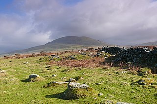
Ardudwy is an area of Gwynedd in north-west Wales, lying between Tremadog Bay and the Rhinogydd. Administratively, under the old Kingdom of Gwynedd, it was first a division of the sub kingdom (cantref) of Dunoding and later a commote in its own right. The fertile swathe of land stretching from Barmouth to Harlech was historically used as pasture. The name exists in the modern community and village of Dyffryn Ardudwy.

Conwy, previously known in English as Conway, is a walled market town, community and the administrative centre of Conwy County Borough in North Wales. The walled town and castle stand on the west bank of the River Conwy, facing Deganwy on the east bank. The town formerly lay in Gwynedd and prior to that in Caernarfonshire. The community, which also includes Deganwy and Llandudno Junction, had a population of 14,753 at the 2011 census.

Llanrhychwyn is a hamlet in Conwy county borough, Wales. It lies in the Conwy valley, less than a mile south of Trefriw, and a mile north-west of Llanrwst. Today neighbouring Trefriw is a village with a population of around 600, but in the time of Llywelyn Fawr, and up to the early 19th century, Llanrhychwyn was larger than Trefriw, which consisted simply of "a few houses here and there". Indeed, even today both Trefriw and Llanrhychwyn lie within the parish of Llanrhychwyn. The area around Llanrhychwyn had a population of only 178 in 2011.

Saint Peris was a little-known Welsh saint of the early Christian period, possibly 6th century.

Cantre'r Gwaelod, also known as Cantref Gwaelod or Cantref y Gwaelod, is a legendary ancient sunken kingdom said to have occupied a tract of fertile land lying between Ramsey Island and Bardsey Island in what is now Cardigan Bay to the west of Wales. It has been described as a "Welsh Atlantis" and has featured in folklore, literature, and song.

Llangelynnin is a former parish in the Conwy valley, in Conwy county borough, north Wales. Today the name exists only in connection with the church, a school in the nearby village of Henryd, and the nearby mountain ridge, Craig Celynnin.
Llys Helig is the name of a natural rock formation off the coast at Penmaenmawr, north Wales. There may be a fish weir to the south which tradition dates to the beginning of the 6th century. The sea level was low enough around 1600 AD to make the claims of Sir John Wynne of Gwydir feasible. The earliest known use of the name Llys Helig for this rock formation is the Halliwell Manuscript which is believed to date to around the beginning of the 17th century, eleven centuries later. Legends developed about it suggesting that it was the palace of Prince Helig ap Glanawg who lived in the 6th century, and whose sons established a number of churches in the area. He owned a large area of land between the Great Orme's Head near Llandudno and the Menai Strait off the north coast of Gwynedd.
Llan and its variants are a common element of Celtic placenames in the British Isles and Brittany, especially of Welsh toponymy. In Welsh the name of a local saint or a geomorphological description follows the Llan morpheme to form a single word: for example Llanfair is the parish or settlement around the church of St. Mair. Goidelic toponyms end in -lann.

St Brothen's Church, Llanfrothen, is a redundant church at the edge of the village of Llanfrothen, Gwynedd, Wales. It is designated by Cadw as a Grade I listed building because it is "a fine Medieval church retaining much of exterior and interior interest". It is under the care of the Friends of Friendless Churches.

Dwygyfylchi is a village in Conwy County Borough, Wales. It is part of the community of Penmaenmawr which has a population of 4,353. The electoral ward of Capelulo which includes Dwygyfylchi had a population of 1,485 in 2011. It forms part of the historic county of Caernarfonshire.
The Bells of Aberdovey is a popular song which refers to the village now usually known locally by its Welsh-language name of Aberdyfi in Gwynedd, Wales at the mouth of the River Dyfi on Cardigan Bay. The song is based on the legend of Cantre'r Gwaelod, which is also called Cantref Gwaelod or Cantref y Gwaelod. This ancient sunken kingdom is said to have occupied a tract of fertile land lying between Ramsey Island and Bardsey Island in what is now Cardigan Bay to the west of Wales. The legend supposes that the bells of the submerged lost kingdom can be heard ringing below the waves on the beach at Aberdyfi.
Bodfan was a Welsh saint in the Catholic and Anglican churches.
Rhychwyn was a 6th century saint of North Wales and the patron saint of Llanrhychwyn.

The Diocese of Bangor is a diocese of the Church in Wales in North West Wales. The diocese covers Anglesey, most of Caernarfonshire and Merionethshire and the western part of Montgomeryshire.
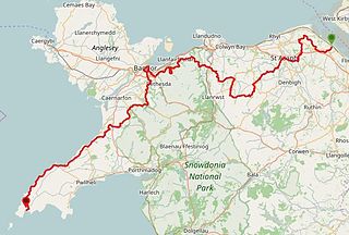
The North Wales Pilgrim's Way is a long-distance walking route in North Wales, running from near Holywell in the east to Bardsey Island in the west. The first half of the trail takes an inland route, with the second half following the north coast of the Llŷn Peninsula. It measures 133.9 miles (215 km) in length, and was officially launched at Porth y Swnt, Aberdaron on 10 July 2014.

The coastline of Wales extends from the English border at Chepstow westwards to Pembrokeshire then north to Anglesey and back eastwards to the English border once again near Flint. Its character is determined by multiple factors, including the local geology and geological processes active during and subsequent to the last ice age, its relative exposure to or shelter from waves, tidal variation and the history of human settlement and development which varies considerably from one place to another. The majority of the coast east of Cardiff in the south, and of Llandudno in the north, is flat whilst that to the west is more typically backed by cliffs. The cliffs are a mix of sandstones, shales and limestones, the erosion of which provides material for beach deposits. Of the twenty-two principal areas which deliver local government in Wales, sixteen have a coastline, though that of Powys consists only of a short section of tidal river some distance from the open sea. Its length has been estimated at 1,680 miles (2,700 km).