Abingdon-on-Thames, commonly known as Abingdon, is a historic market town and civil parish on the River Thames in the Vale of the White Horse district of Oxfordshire, England. The historic county town of Berkshire, the area was occupied from the early to middle Iron Age and the remains of a late Iron Age and Roman defensive enclosure lies below the town centre. Abingdon Abbey was founded around 676, giving its name to the emerging town. In the 13th and 14th centuries, Abingdon was an agricultural centre with an extensive trade in wool, alongside weaving and the manufacture of clothing. Charters for the holding of markets and fairs were granted by various monarchs, from Edward I to George II.

Culham is a village and civil parish in a bend of the River Thames, 1 mile (1.6 km) south of Abingdon in Oxfordshire. The parish includes Culham Science Centre and Europa School UK. The parish is bounded by the Thames to the north, west and south, and by present and former field boundaries to the east. It is low-lying and fairly flat, rising from the Thames floodplain in the south to a north-facing escarpment in the north up to 260 feet (80 m) above sea level. The 2011 Census recorded its population as 453.

Cropredy Bridge is a bridge in north Oxfordshire, England, that carries the minor road between Cropredy and the hamlet of Williamscot. It spans the River Cherwell, which is also the boundary between the civil parishes of Wardington and Cropredy. The bridge has three spans, a reinforced concrete deck and is faced with Hornton stone. Each of the three spans is 12 feet (3.7 m). The present bridge was completed in 1937, but there has been a bridge on this site since at least 1312.

Clifton Hampden is a village and civil parish on the north bank of the River Thames, just over 3 miles (5 km) east of Abingdon in Oxfordshire. Since 1932 the civil parish has included the village of Burcot, 1 mile (1.6 km) east of Clifton Hampden. The 2011 Census recorded the parish population as 662.

Folly Bridge is a stone bridge over the River Thames carrying the Abingdon Road south from the centre of Oxford, England. It was erected in 1825–27, to designs of a little-known architect, Ebenezer Perry, who practised in London.

Wallingford Bridge is a medieval road bridge over the River Thames in England which connects Wallingford and Crowmarsh Gifford, Oxfordshire. It crosses the Thames on the reach between Cleeve Lock and Benson Lock. The bridge is 900 feet (270 m) long and has 19 arches. It is a scheduled monument. Since the construction of the southern Wallingford bypass in 1993, most traffic crossing the Thames at the town uses Winterbrook Bridge.
Clifton Lock is a lock on River Thames in Oxfordshire, England. It is located south of the village of Clifton Hampden and north of Long Wittenham. It is at the start of the Clifton Cut, which bypasses the river to the north of Long Wittenham. The lock was completed in 1822 by the Thames Navigation Commissioners.
Swinford Toll Bridge is a privately owned toll bridge across the Thames in Oxfordshire, England. It crosses the river just above Eynsham Lock, between the village of Eynsham on the north-west bank and the hamlet of Swinford on the south-east bank. It carries the B4044 between Oxford and Eynsham, which was the A40 road until the north Oxford bypass was completed in 1936.

Benson Lock is a lock on the River Thames in England, close to Benson, Oxfordshire but on the opposite bank of the river. The first pound lock here was built by the Thames Navigation Commission in 1788 and it was replaced by the present masonry lock in 1870. The distance between Benson Lock and Cleeve Lock downstream is 6.5 miles (10.4 km) - the longest distance between locks on the River Thames.

Shillingford Bridge is Grade II* listed road bridge near Shillingford, Oxfordshire, carrying an unclassified road across the River Thames in England on the reach above Benson Lock. The bridge provides access between Shillingford to the north of the river and Wallingford to the south. Originally the south side was in Berkshire but was transferred from Berkshire to Oxfordshire in 1974. The bridge is single track and vehicular passage is controlled by traffic lights.

Culham Lock is a lock on the River Thames in England close to Culham, Oxfordshire. It is on a lock cut to the north of the main stream, which approaches the large village of Sutton Courtenay. The lock was built of stone by the Thames Navigation Commission in 1809.

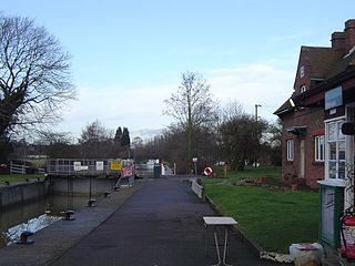
Abingdon Lock is a lock on the River Thames in England, less than 1 mile east and upstream of Abingdon, Oxfordshire, on the opposite bank of the river. It was originally built in 1790 by the Thames Navigation Commission.

Shifford Lock is a lock on the River Thames in England. It is in the centre of a triangle formed by the small villages of Shifford, Duxford and Chimney in Oxfordshire. It is at the start of a navigation cut built with the lock by the Thames Conservancy in 1898. This was the only new lock built on the non-tidal Thames in the era of falling revenue after the Thames Conservancy took over responsibilities of the Thames Navigation Commission. It replaced a flash lock in a weir about 3⁄4 mile (1.2 km) downstream.

Radcot Lock is a lock on the River Thames in England just downstream of Radcot, Oxfordshire, on the southern bank.

Appleford Railway Bridge carries the Cherwell Valley Line from Didcot to Oxford across the River Thames near the village of Appleford-on-Thames, Oxfordshire, England. It crosses the Thames on the reach between Clifton Lock and Culham Lock.
Sutton Bridge is a road bridge across the River Thames near the village of Sutton Courtenay, Oxfordshire, England. It is a stone structure built in 1807 with three arches over the main river and two smaller ones across the flood plain. An extension was built in 1809 across the Culham Cut, just below Culham Lock. It was originally a toll bridge and replaced an earlier multi-arch bridge over the original weir and a ferry at this site. It is a Grade II listed building.

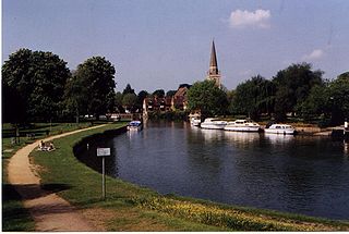
Andersey Island is a 273-acre (110.5 ha) area of flood-meadow and former flood-meadow south-east of Abingdon Bridge, Abingdon, Oxfordshire on the reach above Culham Lock in which parish it lies however maintaining close links with Abingdon by virtue of its current amenities. It is the second-largest island of the non-tidal course of the River Thames in England upstream of the Tideway — if disqualifying the villages of Dorney and Eton, Berkshire enclosed by the engineered Jubilee River. Andersey means Andrew's island after its chapel to St Andrew, demolished, built about 1050 CE.
The Swift Ditch is a 2 km (1.2 mi) long artificial channel that formed a short-cut for river traffic to and from Oxford, across a meander of the River Thames in England. It was formerly the primary navigation channel. With the main river, it creates Andersey Island on the left bank of the Thames opposite Abingdon-on-Thames. Within a poem published in 1632, the Water Poet John Taylor wrote:
At Abingdon the shoals are worse and worse
That Swift Ditch seems to be the better course

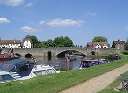
Nag's Head Island is an island in the River Thames in Oxfordshire, England at Abingdon. It sits in the middle of the two Abingdon Bridges on the reach above Culham Lock.

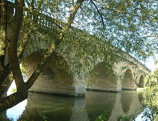
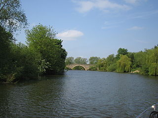
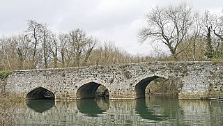
Culham Bridge is a medieval bridge crossing a present backwater of the River Thames in England at Culham, Oxfordshire, near the town of Abingdon. The bridge crosses Swift Ditch which was at one time the main navigation channel of the River Thames until Abingdon Lock was built in 1790. The bridge formerly carried the A415 road from Abingdon to Dorchester, Oxfordshire, but was superseded in 1928 by a modern road bridge.