Culham Lock

Last updated

Culham Lock
2008-05 Culham Lock (2).JPG
Culham lock from upstream
Culham Lock
Waterway River Thames
County Oxfordshire
Maintained by Environment Agency
OperationHydraulic
First built1809
Length39.87 m (130 ft 10 in) [1]
Width5.33 m (17 ft 6 in) [1]
Fall2.41 m (7 ft 11 in) [1]
Above sea level161'
Distance to
Teddington Lock
82 miles
Culham Lock
BSicon uSTR.svg
River Thames
BSicon uWEIRr.svg
BSicon uexSTRq.svg
BSicon uexSTR+r.svg
weir
BSicon uWEIRr.svg
BSicon uexSTRq.svg
BSicon uexABZg+r.svg
weir
BSicon uexSTR+l.svg
BSicon ueABZgr.svg
BSicon uexSTR.svg
BSicon uxWEIRg.svg
BSicon uFGATEu.svg
BSicon uexSTR.svg
Abingdon Lock & weir
BSicon uexSTRl.svg
BSicon ueABZg+r.svg
BSicon POINTERg@fq.svg
BSicon uexSTR.svg
Swift Ditch
BSicon uABZgl.svg
BSicon uSTR+r.svg
BSicon uexSTR.svg
BSicon uSKRZ-Au.svg
BSicon uSKRZ-Au.svg
BSicon uexSTR.svg
A415 Bridge St, Abingdon
BSicon uABZg+l.svg
BSicon uSTRr.svg
BSicon uexSTR.svg
BSicon uexSTRq.svg
BSicon ueABZg+r.svg
BSicon uexSTR.svg
River Ock
BSicon uLSTR+r.svg
BSicon gSTRq.svg
BSicon ugFGATEl.svg
BSicon ugFABZgr+r.svg
BSicon uexSTR.svg
Wilts & Berks Canal
BSicon uLSTR.svg
BSicon uSTR.svg
BSicon POINTERg@fq.svg
BSicon uexSTR.svg
Andersey Island
BSicon uLSTR.svg
BSicon uddHSTRg.svg
BSicon uFABZgr+r.svg
BSicon uexSTR.svg
marina
BSicon uLSTR.svg
BSicon uSTR.svg
BSicon uexSKRZ-Au.svg
A415 Abingdon Road
BSicon uLSTR.svg
BSicon ueABZg+l.svg
BSicon uexSTRq.svg
BSicon uexSTRr.svg
BSicon POINTERg@fq.svg
BSicon uLSTR.svg
BSicon uSTR.svg
Proposed W&B link
BSicon uLSTRl.svg
BSicon uKHSTaq.svg
BSicon uLSTRq.svg
BSicon uFKRZ.svg
BSicon uSTR+r.svg
New Wilts and Berks Jn
BSicon uexSTR+l.svg
BSicon uexSTRr.svg
BSicon uSTR.svg
BSicon uxWEIRr.svg
BSicon uexSTR+r.svg
BSicon uSTR.svg
weir
BSicon uxWEIRg.svg
BSicon uBHF.svg
BSicon uSTR.svg
Sutton Pools
BSicon uexSTRl.svg
BSicon ueABZg+r.svg
BSicon uFGATEu.svg
Culham Lock
BSicon uSKRZ-Eu.svg
BSicon uSKRZ-Eu.svg
Abingdon Road bridges
BSicon uSTRl.svg
BSicon uABZg+r.svg
BSicon uSTR.svg
River Thames

Culham Lock is a lock on the River Thames in England close to Culham, Oxfordshire. It is on a lock cut to the north of the main stream, which approaches the large village of Sutton Courtenay. The lock was built of stone by the Thames Navigation Commission in 1809.

Contents

The associated weirs are on the old course of the river under the massive causeway which separates the millstream from picturesque Sutton Pools. The causeway is very old and was thought to have been built by Saxon labour.

History

The river originally passed close to Sutton Courtenay and under a large mill there. In 1667 occurs the first reference to a pound lock underneath this mill. This had a set of gates beneath the mill floor and included a wide pool at the back of the mill. Consequently, it required a very large volume of water to fill it and so incurred a heavy toll. There were complaints to the Thames Navigation Commission in 1772 that the floor of the mill was a great obstruction to navigation. Although it was privately owned, the Commission undertook some improvements in 1789, but complaints persisted on the grounds of inconvenience and high tolls. [2]

In 1803, Zachary Allnutt of Henley was appointed as Surveyor to the second and third districts of the Thames, which stretched from Mapledurham to Staines. He replaced John Clarke, who died that year, and was the son of Henry Allnutt, who was clerk to the Thames Commission from 1771 to 1820. Before his appointment, he had carried out a number of surveys for the Commission, including one for a new lock at Culham in 1802, but the scale of the works were larger than any previously undertaken, and the plan was not implemented immediately. However, he made a further survey in 1809, and work began in June, on the longest cut ever made on the Thames. It was 1,400 yards (1,300 m) long, with a lock at the lower end, constructed with stone walls, and with a relatively large drop for the time of 7 feet (2.1 m). A stone bridge with a span of 20 feet (6.1 m) was built to carry a road across the cut, and the work took just over a year to complete. The total cost of the project was just under £9,000, which included the purchase of the land. The project was overseen by George Treacher, who was awarded £100 in recognition of his services, when it was completed. [3] Part of the older towpath around the backwater fell into disuse after the lock was built.

Access to the lock

The lock can be reached from the road at Sutton Bridge, Oxfordshire or on foot across the fields from Sutton Courtenay.

Reach above the lock

The navigation follows the lock cut upstream, at the end of the cut is the main river weirstream past Sutton Pools, then the river turns sharply to the right. A new junction for the Wilts & Berks Canal has been constructed almost opposite the top end of Culham Cut as part of a restoration project. The junction was opened on 30 August 2006, and initially runs for about 150 yd (137m) to a winding hole, but will eventually link to the historic route of the canal to the west of Abingdon. [4]

Abingdon riverside from the other side of the river Abingdon Berks St Helens.jpg
Abingdon riverside from the other side of the river

About halfway along the river on the eastern bank the Swift Ditch rejoins the main stream. This backwater was formerly the main course of the river and is crossed by a footbridge and the ancient Culham Bridge. The Swift Ditch creates Andersey Island, one of the largest islands on the Thames. On the Thames side there is an attractive piece of parkland before Abingdon Bridge. On the opposite side here is the town of Abingdon. After the bricked-up former entrance to the Wilts & Berks Canal there is an iron bridge over the mouth of the River Ock and then the town quayside. The river is crossed by Abingdon Bridge which is divided into two (the part across the main navigation being Burford Bridge) by Nag's Head Island. Beyond this on the Abingdon side is parkland associated with Abingdon Abbey.

There is a rowing club on the reach which is the site of the Abingdon Head race.

The Thames Path follows the eastern bank over Culham Bridge and Andersey Island to Abingdon Lock, where it crosses over to the other side.

Next crossing upstream River Thames Next crossing downstream
Abingdon Bridge (road)Culham Lock bridges Sutton Bridge (road)
Next lock upstream River Thames Next lock downstream
Abingdon Lock
4.15 km (2.58 mi) [5]
Culham Lock
Grid reference SU507948
Clifton Lock
4.52 km (2.81 mi) [5]

See also

Related Research Articles

<span class="mw-page-title-main">Wilts & Berks Canal</span> Canal linking the Kennet & Avon Canal to the River Thames

The Wilts & Berks Canal is a canal in the historic counties of Wiltshire and Berkshire, England, linking the Kennet and Avon Canal at Semington near Melksham, to the River Thames at Abingdon. The North Wilts Canal merged with it to become a branch to the Thames and Severn Canal at Latton near Cricklade. Among professional trades boatmen, the canal was nicknamed the Ippey Cut, possibly short for Chippenham.

<span class="mw-page-title-main">Thames and Severn Canal</span> Canal in Gloucestershire in the south-west of England

The Thames and Severn Canal is a canal in Gloucestershire in the south-west of England, which was completed in 1789. It was conceived as part of a cargo route from Bristol and the Midlands to London, linking England's two largest rivers for better trade. The route climbs the steep Cotswold escarpment through the Golden Valley, tunnels underneath the summit of the Cotswold Edge, and emerges near the source of the Thames.

<span class="mw-page-title-main">Teddington Lock</span> Series of locks on the River Thames in London

Teddington Lock is a complex of three locks and a weir on the River Thames between Ham and Teddington in the London Borough of Richmond upon Thames, England. Historically in Middlesex, it was first built in 1810.

<span class="mw-page-title-main">Whitchurch Lock</span> Lock and weir on the River Thames in Oxfordshire, England

Whitchurch Lock is a lock and weir on the River Thames in England. It is a pound lock, built by the Thames Navigation Commissioners in 1787. It is on an island near the Oxfordshire village of Whitchurch-on-Thames and is accessible only by boat.

<span class="mw-page-title-main">Culham</span> Human settlement in England

Culham is a village and civil parish in a bend of the River Thames, 1 mile (1.6 km) south of Abingdon in Oxfordshire. The parish includes Culham Science Centre and Europa School UK. The parish is bounded by the Thames to the north, west and south, and by present and former field boundaries to the east. It is low-lying and fairly flat, rising from the Thames floodplain in the south to a north-facing escarpment in the north up to 260 feet (80 m) above sea level. The 2011 Census recorded its population as 453.

<span class="mw-page-title-main">Thames Path</span> National Trail following the River Thames in England

The Thames Path is a National Trail following the River Thames from one of its sources near Kemble in Gloucestershire to the Woolwich foot tunnel, south east London. It is about 185 miles (298 km) long. A path was first proposed in 1948 but it only opened in 1996.

<span class="mw-page-title-main">Boulter's Lock</span> Lock and weir on the River Thames, England

Boulter's Lock is a lock and weir on the River Thames in England north-east of Maidenhead town centre, Berkshire. The present 1912-built lock replaces those at this point of the river to the immediate east dating from the late 16th century and that of 1772 built by the Thames Navigation Commission. The lock is on the western side of the north-south flowing reach between the A4094 Maidenhead to Cookham road and Ray Mill Island. The name is variably used for the immediate surrounding area.

<span class="mw-page-title-main">River Ock</span> River in Oxfordshire, England

The River Ock is a small English river which is a tributary of the River Thames. It has as its catchment area the Vale of White Horse, a low-lying and wide valley in south Oxfordshire, and flows into the River Thames, at Abingdon on the reach above Culham Lock.

<span class="mw-page-title-main">Clifton Lock</span>

Clifton Lock is a lock on River Thames in Oxfordshire, England. It is located south of the village of Clifton Hampden and north of Long Wittenham. It is at the start of the Clifton Cut, which bypasses the river to the north of Long Wittenham. The lock was completed in 1822 by the Thames Navigation Commissioners.

<span class="mw-page-title-main">Wey and Godalming Navigations</span> Waterways in Surrey, England

The River Wey Navigation and Godalming Navigation together provide a 20-mile (32 km) continuous navigable route from the River Thames near Weybridge via Guildford to Godalming. Both waterways are in Surrey and are owned by the National Trust. The River Wey Navigation connects to the Basingstoke Canal at West Byfleet, and the Godalming Navigation to the Wey and Arun Canal near Shalford. The Navigations consist of both man-made canal cuts and adapted parts of the River Wey.

<span class="mw-page-title-main">Stroudwater Navigation</span> Canal in Gloucestershire, England

The Stroudwater Navigation is a canal in Gloucestershire, England which linked Stroud to the River Severn. It was authorised in 1776, although part had already been built, as the proprietors believed that an Act of Parliament obtained in 1730 gave them the necessary powers. Opened in 1779, it was a commercial success, its main cargo being coal. It was 8 miles (13 km) in length and had a rise of 102 ft 5 in (31.22 m) through 12 locks. Following the opening of the Thames and Severn Canal in 1789, it formed part of a through route from Bristol to London, although much of its trade vanished when the Kennet and Avon Canal provided a more direct route in 1810. Despite competition from the railways, the canal continued to pay dividends to shareholders until 1922, and was not finally abandoned until 1954.

<span class="mw-page-title-main">Abingdon Lock</span>

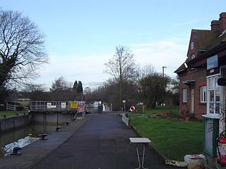
Abingdon Lock is a lock on the River Thames in England, less than 1 mile east and upstream of Abingdon, Oxfordshire, on the opposite bank of the river. It was originally built in 1790 by the Thames Navigation Commission.

<span class="mw-page-title-main">Osney Lock</span> Lock on the River Thames in Oxfordshire, England

Osney Lock is a lock on the River Thames in Oxford, England, where the village or island of Osney is next to the river.

<span class="mw-page-title-main">Sutton Bridge, Oxfordshire</span> Bridge in Sutton Courtenay, Oxfordshire

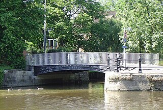
Sutton Bridge is a road bridge across the River Thames near the village of Sutton Courtenay, Oxfordshire, England. It is a stone structure built in 1807 with three arches over the main river and two smaller ones across the flood plain. An extension was built in 1809 across the Culham Cut, just below Culham Lock. It was originally a toll bridge and replaced an earlier multi-arch bridge over the original weir and a ferry at this site. It is a Grade II listed building.

<span class="mw-page-title-main">Abingdon Bridge</span> Bridge in Abingdon, Oxfordshire

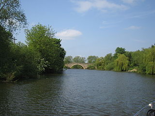
Abingdon Bridge crosses the River Thames at the town of Abingdon, Oxfordshire, England. It carries the A415 road from Abingdon to Dorchester, Oxfordshire, over the reach of the Thames between Culham Lock and Abingdon Lock.

<span class="mw-page-title-main">Andersey Island</span>

Andersey Island is a 273-acre (110.5 ha) area of flood-meadow and former flood-meadow south-east of Abingdon Bridge, Abingdon, Oxfordshire on the reach above Culham Lock in which parish it lies however maintaining close links with Abingdon by virtue of its current amenities. It is the second-largest island of the non-tidal course of the River Thames in England upstream of the Tideway — if disqualifying the villages of Dorney and Eton, Berkshire enclosed by the engineered Jubilee River. Andersey means Andrew's island after its chapel to St Andrew, demolished, built about 1050 CE.

<span class="mw-page-title-main">Swift Ditch</span>

The Swift Ditch is a 2 km (1.2 mi) long artificial channel that formed a short-cut for river traffic to and from Oxford, across a meander of the River Thames in England. It was formerly the primary navigation channel. With the main river, it creates Andersey Island on the left bank of the Thames opposite Abingdon-on-Thames. Within a poem published in 1632, the Water Poet John Taylor wrote:

At Abingdon the shoals are worse and worse
That Swift Ditch seems to be the better course

<span class="mw-page-title-main">Hackney Cut</span> Canal in East London

The Hackney Cut is an artificial channel of the Lee Navigation built in England in 1769 by the River Lea Trustees to straighten and improve the Navigation. It begins at the Middlesex Filter Beds Weir, below Lea Bridge, and is situated in the (modern) London Borough of Hackney. When built it contained two pound locks and a half-lock, but was rebuilt to handle larger barges in the 1850s, and now only Old Ford Lock, which is actually a duplicated pair, remains.

<span class="mw-page-title-main">Culham Bridge</span> Bridge in Abingdon, Oxfordshire

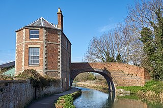
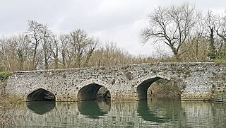
Culham Bridge is a medieval bridge crossing a present backwater of the River Thames in England at Culham, Oxfordshire, near the town of Abingdon. The bridge crosses Swift Ditch which was at one time the main navigation channel of the River Thames until Abingdon Lock was built in 1790. The bridge formerly carried the A415 road from Abingdon to Dorchester, Oxfordshire, but was superseded in 1928 by a modern road bridge.

<span class="mw-page-title-main">Sutton Pools</span>

Sutton Pools are a picturesque backwater formed by a number of weirs, islands, footbridges and barriers on the course of the River Thames at Sutton Courtenay, Oxfordshire, England. The higher level of the river is separated from the lower pools by a causeway which dates from Saxon times. This river stretch ceased to be the main navigable route after Culham Cut was constructed in the early 19th century, which also created an island to the north of the Pools. In addition there are three smaller islands, linked by footbridges over the weirs, part of a footpath between Sutton Courtenay and the village of Culham.

References

  1. 1 2 3 "Environment Agency Dimensions of locks on the River Thames". web page. Environmental Agency. 8 November 2012. Retrieved 17 November 2012. Dimensions given in metres
  2. Fred. S. Thacker The Thames Highway: Volume II Locks and Weirs 1920 - republished 1968 David & Charles
  3. Skempton 1996, p. 164.
  4. "Grand Opening of Jubilee Junction". Archived from the original on 23 July 2008. Retrieved 2 January 2008.
  5. 1 2 "Environment Agency Distances between locks on the River Thames". web page. Environmental Agency. 19 November 2012. Retrieved 20 November 2012. Distances given in km

Bibliography

51°39′01″N1°16′03″W / 51.6504°N 1.2676°W / 51.6504; -1.2676