Abingdon Lock

Last updated

Abingdon Lock
AbingdonLock01.JPG
Abingdon Lock with Abingdon downstream in the distance. The silver parasols are to shade the lock-keeper while operating the controls. Yellow boards on the gates indicate a high stream
Waterway River Thames
County Oxfordshire
Maintained by Environment Agency
OperationHydraulic
First built1790
Latest built1905
Length36.57 m (120 ft 0 in) [1]
Width5.71 m (18 ft 9 in) [1]
Fall1.89 m (6 ft 2 in) [1]
Above sea level167'
Distance to
Teddington Lock
85 miles
Coordinates 51°40′14″N1°16′09″W / 51.670535°N 1.269202°W / 51.670535; -1.269202 Coordinates: 51°40′14″N1°16′09″W / 51.670535°N 1.269202°W / 51.670535; -1.269202
Abingdon Lock
BSicon uCONTg.svg
River Thames
BSicon uexSTR+l.svgBSicon ueABZgr.svg
BSicon uxWEIRg.svgBSicon uSTR.svg
weir
BSicon uexABZg+l.svgBSicon uWEIRl.svg
weir
BSicon uexSTR.svgBSicon ueABZgl.svgBSicon uexSTR+r.svg
BSicon uexSTR.svgBSicon uFGATEu.svg
BSicon uMILL.svg
BSicon uexSTR.svg
Sandford Lock and mill
BSicon uexSTR.svgBSicon ueABZg+l.svgBSicon uexSTRr.svg
BSicon uexSTRl.svgBSicon ueABZg+r.svg
BSicon ueISLAND.svg
Lock Wood Island
BSicon CONTgq.svgBSicon umKRZu.svgBSicon CONTfq.svg
Nuneham Railway Bridge
BSicon uWEIRr.svgBSicon uexSTR+r.svg
weir
BSicon uWEIRr.svgBSicon uexABZg+r.svg
weir
BSicon uexSTR+l.svgBSicon ueABZgr.svg
BSicon POINTERg@fq.svg
BSicon uexSTR.svg
Swift Ditch
BSicon uxWEIRg.svgBSicon uFGATEu.svgBSicon uexSTR.svg
Abingdon Lock & weir
BSicon uexSTRl.svgBSicon ueABZg+r.svgBSicon uexCONTf.svg
BSicon uCONTf.svg
River Thames
Abingdon Lock in action Abingdon Lock.jpg
Abingdon Lock in action

Abingdon Lock is a lock on the River Thames in England, less than 1 mile east and upstream of Abingdon, Oxfordshire, on the opposite bank of the river. It was originally built in 1790 by the Thames Navigation Commission.

River Thames river in southern England

The River Thames, known alternatively in parts as the Isis, is a river that flows through southern England including London. At 215 miles (346 km), it is the longest river entirely in England and the second longest in the United Kingdom, after the River Severn.

The Thames Navigation Commission managed the River Thames in southern England from 1751 to 1866. In particular, they were responsible for installing or renovating many of the locks on the river in the 18th and early 19th centuries

Contents

The weir runs across from the Abingdon side to the lock island, and has a pedestrian walkway across it.

According to a tablet above the front door, the current lock-keeper's house dates from 1928. Ice creams and refreshments have been sold from the door of the house for at least 30 years.

History

Walkway across Abingdon Weir. AbingdonWeir01.JPG
Walkway across Abingdon Weir.

The navigation route in the vicinity of Abingdon has been subject to change over the centuries. The Swift Ditch further to the east was the original course of the river Thames. The stream to the town was developed by the monks of Abingdon Abbey and the original weir is reputed to have been built by them during the 10th century. A pound lock was built on the Swift Ditch by the Oxford-Burcot Commission in 1635 making it then the navigation route. In 1788 several citizens of Abingdon wanted to divert navigation back to the current course, possibly taking into account the Wilts & Berks Canal which was to connect to the current navigation channel at Abingdon within ten years. As a result, Abingdon Lock was built near the town and opened at the end of 1790. The lock-keeper's house was reported in 1811 to be half a mile downstream of the lock - probably at the abbey millhouse. [2]

Swift Ditch

The Swift Ditch is a backwater of the River Thames in England, which was formerly the primary navigation channel. With the main river, it creates the large island of Andersey Island near Abingdon, Oxfordshire.

Abingdon Abbey Grade I listed abbey in Abingdon, United Kingdom

Abingdon Abbey was a Benedictine monastery also known as St Mary's Abbey located in Abingdon, historically in the county of Berkshire but now in Oxfordshire, England.

The Oxford-Burcot Commission was the first Commission concerned with the management of the River Thames, appointed by an Act of Parliament of 1605 by James I to make the stretch of river from Burcot to Oxford navigable. The Commission took responsibility for the management of the River Thames between Oxford and Burcot. It consisted of 18 members, including a representative each from Oxford city and from the University. However its work was irregular and by 1611 it had ceased altogether.

Access to the lock

The lock can be reached on a track heading north from Abingdon Bridge on the Andersey Island side. Alternatively it is possible to walk along the river from the town centre through Abbey Meadows and cross the weir.

Abingdon Bridge bridge over the River Thames at the town of Abingdon, Oxfordshire, England

Abingdon Bridge crosses the River Thames at the town of Abingdon, Oxfordshire, England. It carries the A415 road from Abingdon to Dorchester, Oxfordshire, over the reach of the Thames between Culham Lock and Abingdon Lock.

Andersey Island island in the River Thames in England

Andersey Island is a 273-acre (110.5 ha) area of flood-meadow and former flood-meadow south-east of Abingdon Bridge, Abingdon, Oxfordshire on the reach above Culham Lock in which parish it lies however maintaining close links with Abingdon by virtue of its current amenities. It is the second-largest island of the non-tidal course of the River Thames in England upstream of the Tideway — if disqualifying the villages of Dorney and Eton, Berkshire enclosed by the engineered Jubilee River. Andersey means Andrew's island after its chapel to St Andrew, demolished, built about 1050 CE.

Reach above the lock

Nuneham House from the river NunehamHouse01.JPG
Nuneham House from the river

Immediately above the weir towards the town is the channel cut by the monks of Abingdon Abbey in the 10th century to provide navigation and mill water to the abbey itself. For the first few hundred yards the river has turned back on itself making the northern bank temporarily on the southern side. On this side of the lock is Andersey Island created by Swift Ditch. The first outflow is the site of the old lock, and the second channel is the original weir stream. Further upstream the Nuneham Railway Bridge (known as Black Bridge) carried the railway line to Oxford. Upstream of this the river turns northwards at the heavily wooded Lock Wood Island on the eastern bank with the old Radley Boathouse on the opposite side. Beyond the island the river is flanked by Nuneham Park, belonging to Nuneham House with the Jacobean Carfax Water Tower on a hill in the grounds ahead of the Palladian house itself. On the western side the terrain is open farmland with the town of Radley beyond. Near here and on that side on the river is the Radley College boathouse. On the opposite side, meadows for grazing cattle stretch up to Sandford Lock.

Nuneham Railway Bridge bridge in United Kingdom

Nuneham Railway Bridge is a railway bridge in England near the town of Abingdon, Oxfordshire. It carries the Cherwell Valley Line between Didcot and Oxford across the River Thames between Abingdon Lock and Sandford Lock. The current bridge was built in 1929 and has also been called the Black Bridge. It replaced an earlier wooden bridge built in 1844.

Lock Wood Island island in the River Thames in England

Lock Wood Island is an island in the River Thames in England just downstream of Nuneham House on the reach above Abingdon Lock.

Nuneham House

Nuneham House is an eighteenth century villa in the Palladian style, set in parkland at Nuneham Courtenay in Oxfordshire, England. It is currently owned by Oxford University and is used as a retreat centre by the Brahma Kumaris World Spiritual University. In September 2016 the house and a thousand acres of surrounding parkland was put up for sale for £22 million.

The Thames Path, which crosses the river at the lock, follows the western bank all the way to Sandford Lock.

Thames Path long-distance trail following the River Thames in England

The Thames Path is a National Trail following the River Thames from its source near Kemble in Gloucestershire to the Thames Barrier at Charlton, south east London. It is about 184 miles (296 km) long. A path was first proposed in 1948 but it only opened in 1996.

See also

Next lock upstream River Thames Next lock downstream
Sandford Lock
7.38 km (4.59 mi) [3]
Abingdon Lock
Grid reference: SU506971
Culham Lock
4.15 km (2.58 mi) [3]
Next crossing upstream River Thames Next crossing downstream
Nuneham Railway Bridge Abingdon Lock Abingdon Bridge
Next crossing upstream Thames Path Next crossing downstream
"southern*" bank
Osney Bridge
Abingdon Locknorthern bank
Clifton Hampden Bridge

Related Research Articles

Locks and weirs on the River Thames Wikimedia list article

The English River Thames is navigable from Cricklade or Lechlade to the sea, and this part of the river falls 71 meters (234 feet). There are 45 locks on the river, each with one or more adjacent weirs. These lock and weir combinations are used for controlling the flow of water down the river, most notably when there is a risk of flooding, and provide for navigation above the tideway.

Teddington Lock

Teddington Lock is a complex of three locks and a weir on the River Thames in England between Ham and Teddington in the London Borough of Richmond upon Thames. It was first built in 1810.

Caversham Lock

Caversham Lock is a lock and main weir on the River Thames in England at Reading, Berkshire. Both structures connect to De Bohun Island, a long island. The original lock was built by the Thames Navigation Commissioners in 1778. Additional sluices north of verdant View Island and multiple home Heron Island form the whole weir complex. A footbridge passes over all three islands to connect Lower Caversham to Reading via an alternative route than George Street and Reading Bridge.

Marsh Lock lock and weir situated on the River Thames in England near Henley-on-Thames

Marsh Lock is a lock and weir situated on the River Thames in England near Henley-on-Thames, Oxfordshire. The lock is close to the Berkshire bank, but accessed from the Oxfordshire side via two long walkways, the downstream one being near Mill Meadows. The first pound lock was built by the Thames Navigation Commission in 1773.

Sonning Lock

Sonning Lock is a lock and associated weir situated on the River Thames at the village of Sonning near Reading, Berkshire, England. The first lock was built by the Thames Navigation Commission in 1773 and it has been rebuilt three times since then. There is a weir a little upstream at the top of the island where Sonning Backwater separates from the main course of the river.

Bray Lock

Bray Lock is a lock and weir on the River Thames in England near Bray and Dorney Reach, and is just above the M4 Bridge across the Thames. The lock is on the Buckinghamshire side of the river on the opposite bank from Bray itself and Maidenhead which are in Berkshire. Here, the county line stands roughly halfway between the lock and the opposite bank, following the course of the Thames itself. The pound lock was built by the Thames Navigation Commission relatively late in 1845 The lock keeper's cottage is on an island between the lock and the weir.

Sandford-on-Thames village and civil parish in South Oxfordshire, England

Sandford-on-Thames is a village and Parish Council beside the River Thames in Oxfordshire just south of Oxford. The village is just west of the A4074 road between Oxford and Henley.

Hambleden Lock

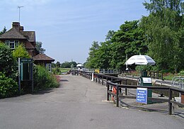
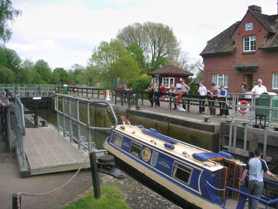
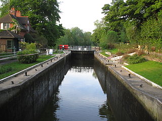
Hambleden Lock is a lock with a long weir situated on the River Thames in England. The lock is on the Berkshire bank between Aston and Remenham. It was built by the Thames Navigation Commission in 1773, The lock is named after the village of Hambleden, a mile (1.5 km) to the north.

Days Lock

Day's Lock is a lock on the River Thames near Dorchester-on-Thames, Oxfordshire, England on the Dorchester side of the river.

Iffley Lock lock in England

Iffley Lock is a lock on the River Thames in England near the village of Iffley, Oxfordshire. It is on the southern outskirts of Oxford. The original lock was built by the Oxford-Burcot Commission in 1631 and the Thames Navigation Commission replaced this in 1793. The lock has a set of rollers to allow punts and rowing boats to be moved between the water levels.

Shepperton Lock

Shepperton Lock is a lock on the River Thames, in England by the left bank at Shepperton, Surrey. It is across the river from Weybridge which is nearby linked by a passenger ferry.

Molesey Lock

Molesey Lock is a lock on the River Thames in England at East Molesey, Surrey on the right bank.

Marlow Lock

Marlow Lock is a lock and weir situated on the River Thames in the town of Marlow, Buckinghamshire, England. The first pound lock was built by the Thames Navigation Commission in 1773.

Chertsey Lock

Chertsey Lock is a lock on the River Thames in England, against the left bank, an area of Green Belt including Laleham Park, the largest public park in Spelthorne. It faces the town of Chertsey and is the fifth-lowest of the forty-four locks along the non-tidal course of the river. Owing to a course alteration both banks at the site of the lock have been since medieval times in Surrey. Stone-built Chertsey Bridge built in 1785 is 210 m south (downstream) of the lock. The lock was built by the City of London Corporation in 1813, lengthened in 1893 and again in 1913.

Boveney Lock lock on the River Thames situated on the Buckinghamshire bank

Boveney Lock is a lock on the River Thames situated on the Buckinghamshire bank opposite the Windsor Racecourse and close to Eton Wick. Boveney is a village a little way upstream on the same side. The lock was first built in 1838 by the Thames Navigation Commission. The lock was rebuilt in 1898 closer to the Buckinghamshire bank, and a set of boat rollers were installed on the old site.

Culham Lock

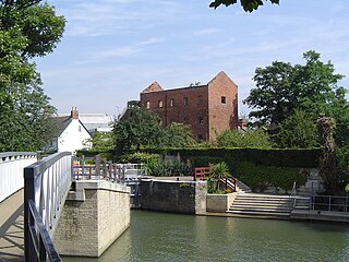
Culham Lock is a lock on the River Thames in England close to Culham, Oxfordshire. It is on a lock cut to the north of the main stream, which approaches the large village of Sutton Courtenay. The lock was built of stone by the Thames Navigation Commission in 1809.

Sandford Lock

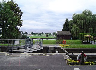
Sandford Lock is a lock on the River Thames in England, situated at Sandford-on-Thames which is just South of Oxford. The first pound lock was built in 1631 by the Oxford-Burcot Commission although this has since been rebuilt. The lock has the deepest fall of all locks on the Thames at 8ft 9in (2.69m) and is connected to a large island which is one of three at this point.

Osney Lock

Osney Lock is a lock on the River Thames in Oxford, England, where the village or island of Osney is next to the river.

Culham Bridge

Culham Bridge is a mediaeval bridge crossing a present backwater of the River Thames in England at Culham, Oxfordshire, near the town of Abingdon. The bridge crosses Swift Ditch which was at one time the main navigation channel of the River Thames until Abingdon Lock was built in 1790. The bridge formerly carried the A415 road from Abingdon to Dorchester, Oxfordshire, but was superseded in 1928 by a modern road bridge.

References

  1. 1 2 3 "Environment Agency Dimensions of locks on the River Thames". web page. Environmental Agency. 8 November 2012. Retrieved 17 November 2012. Dimensions given in metres
  2. Fred. S. Thacker The Thames Highway: Volume II Locks and Weirs 1920 - republished 1968 David & Charles
  3. 1 2 "Environment Agency Distances between locks on the River Thames". web page. Environmental Agency. 19 November 2012. Retrieved 20 November 2012. Distances given in km