Andersey Island

Last updated

Andersey Island AnderseyIsle01.JPG
Andersey Island

Andersey Island is a 273-acre (110.5 ha) area of flood-meadow and former flood-meadow south-east of Abingdon Bridge, Abingdon, Oxfordshire on the reach above Culham Lock in which parish it lies however maintaining close links with Abingdon by virtue of its current amenities. It is the second-largest island of the non-tidal course of the River Thames in England upstream of the Tideway if disqualifying the villages of Dorney and Eton, Berkshire enclosed by the engineered Jubilee River. Andersey means Andrew's island after its chapel to St Andrew, demolished, built about 1050 CE.

Flood-meadow

A flood-meadow is an area of grassland or pasture beside a river, subject to seasonal flooding. Flood-meadows are distinct from water-meadows in that the latter are artificially created and maintained, with flooding controlled on a seasonal and even daily basis.

Abingdon Bridge bridge over the River Thames at the town of Abingdon, Oxfordshire, England

Abingdon Bridge crosses the River Thames at the town of Abingdon, Oxfordshire, England. It carries the A415 road from Abingdon to Dorchester, Oxfordshire, over the reach of the Thames between Culham Lock and Abingdon Lock.

Culham Lock

Culham Lock is a lock on the River Thames in England close to Culham, Oxfordshire. It is on a lock cut to the north of the main stream, which approaches the large village of Sutton Courtenay. The lock was built of stone by the Thames Navigation Commission in 1809.

Contents

Location

The island is created by a natural anabranch (a corollary, specifically a meander cutoff) of the river, the Swift Ditch. Today it is a backwater and since at least the 1800s has been weir-controlled. It comprises 273 acres (1.10 km2) and is the fifth largest island of the river including the outer reaches of its estuary, discounting the area south of the Jubilee River, a channel opened in 2004. [1]

Anabranch A section of a river or stream that diverts from the main channel and rejoins it downstream.

An anabranch is a section of a river or stream that diverts from the main channel or stem of the watercourse and rejoins the main stem downstream. Local anabranches can be the result of small islands in the watercourse. In larger anabranches, the flow can diverge for a distance of several kilometers before rejoining the main channel.

Meander cutoff disconnected meander loop of a river

A meander cutoff, the natural form of a cutting or cut in a river occurs when a pronounced meander (hook) in a river is breached by a flow that connects the two closest parts of the hook to form a new channel, a full loop. The steeper drop in gradient (slope) causes the river flow gradually to abandon the meander which will silt up with sediment from deposition. Cutoffs are a natural part of the evolution of a meandering river. Rivers form meanders as they flow laterally downstream, see sinuosity.

Swift Ditch

The Swift Ditch is a backwater of the River Thames in England, which was formerly the primary navigation channel. With the main river, it creates the large island of Andersey Island near Abingdon, Oxfordshire.

History and uses

History

Andersey in Old English and Middle English means Andrew's island. [2]

Old English, or Anglo-Saxon, is the earliest historical form of the English language, spoken in England and southern and eastern Scotland in the early Middle Ages. It was brought to Great Britain by Anglo-Saxon settlers probably in the mid-5th century, and the first Old English literary works date from the mid-7th century. After the Norman conquest of 1066, English was replaced, for a time, as the language of the upper classes by Anglo-Norman, a relative of French. This is regarded as marking the end of the Old English era, as during this period the English language was heavily influenced by Anglo-Norman, developing into a phase known now as Middle English.

Middle English Stage of the English language from about the 12th through 15th centuries

Middle English was a form of the English language, spoken after the Norman conquest (1066) until the late 15th century. English underwent distinct variations and developments following the Old English period. Scholarly opinion varies, but the Oxford English Dictionary specifies the period when Middle English was spoken as being from 1150 to 1500. This stage of the development of the English language roughly followed the High to the Late Middle Ages.

The island was the site of a royal residence in Anglo-Saxon times, its ruins commonly called the "castell of the rhae" in the times of John Leland (antiquary) (d. 1552) [2] ; the place was favoured by the royalty of Mercia and Wessex. Offa was the first to build a royal residence on Andersey Island and there his son king Ecgfrith of Mercia died in 796. [2]

Anglo-Saxons Germanic tribes who started to inhabit parts of Great Britain from the 5th century onwards

The Anglo-Saxons were a cultural group who inhabited Great Britain from the 5th century, and the direct ancestors of the majority of the modern British people. They comprise people from Germanic tribes who migrated to the island from continental Europe, their descendants, and indigenous British groups who adopted many aspects of Anglo-Saxon culture and language; the cultural foundations laid by the Anglo-Saxons are the foundation of the modern English legal system and of many aspects of English society; the modern English language owes over half its words – including the most common words of everyday speech – to the language of the Anglo-Saxons. Historically, the Anglo-Saxon period denotes the period in Britain between about 450 and 1066, after their initial settlement and up until the Norman conquest. The early Anglo-Saxon period includes the creation of an English nation, with many of the aspects that survive today, including regional government of shires and hundreds. During this period, Christianity was established and there was a flowering of literature and language. Charters and law were also established. The term Anglo-Saxon is popularly used for the language that was spoken and written by the Anglo-Saxons in England and eastern Scotland between at least the mid-5th century and the mid-12th century. In scholarly use, it is more commonly called Old English.

John Leland (antiquary) English poet and antiquary

John Leland or Leyland was an English poet and antiquary.

Mercia One of the kingdoms of the Anglo-Saxon Heptarchy

Mercia was one of the kingdoms of the Anglo-Saxon Heptarchy. The name is a Latinisation of the Old English Mierce or Myrce, meaning "border people". Mercia dominated what would later become England for three centuries, subsequently going into a gradual decline while Wessex eventually conquered and united all the kingdoms into Kingdom of England.

The destroyed palace of sorts was assumed by the Normans and used as a hunting lodge by William I and William II . The site was handed over to the Abbot of Abingdon in about 1100 and the buildings fell to ruin. The main Dorchester-Abingdon road runs through the island from east to west legally declared to have existed so as to claim public right of way from 'time immemorial'. [2] It crosses into Andersey Island via Culham New Bridge, erected in 1928 by the Oxfordshire County Council. Until then, Culham Old Bridge, which lies slightly to the south was in use. The old bridge, now scheduled as an ancient monument, was part of a major scheme for improving links between Abingdon and Dorchester: between 1416 and 1422 the causeway across Andersey and bridges were erected by the Abingdon Guild of the Holy Cross. [2]

Time immemorial is a phrase meaning time extending beyond the reach of memory, record, or tradition, indefinitely ancient, "ancient beyond memory or record".

Henry was persuaded by Queen Maud to return the island to Abingdon's ownership but not parish and to allow the abbot to use the lead from its houses for the roof of the abbey church. A late medieval chronicle indicates that the stone buildings on the island were already in decay. [3]

Henry I of England 12th-century King of England and Duke of Normandy

Henry I, also known as Henry Beauclerc, was King of England from 1100 to his death in 1135. Henry was the fourth son of William the Conqueror and was educated in Latin and the liberal arts. On William's death in 1087, Henry's elder brothers Robert Curthose and William Rufus inherited Normandy and England, respectively, but Henry was left landless. Henry purchased the County of Cotentin in western Normandy from Robert, but William and Robert deposed him in 1091. Henry gradually rebuilt his power base in the Cotentin and allied himself with William against Robert. Henry was present when William died in a hunting accident in 1100, and he seized the English throne, promising at his coronation to correct many of William's less popular policies. Henry married Matilda of Scotland but continued to have a large number of mistresses by whom he had many illegitimate children.

An Oxford-Burcot Commission was established by Acts of 1605 and 1624 to improve the river between Oxford and Burcot. The commission did not make use of the mainstream western meander of the river via Abingdon; instead barges was directed along the backwater between Andersey and Culham Hill, known in early Tudor times as Purden's stream. [2]

Present use

Most of the island is open land of grass, marsh reeds, poplars and willows. In man-made uses it contains a football club, a cricket club, a leisure facility, barns and cottages.

See also

Related Research Articles

Oxfordshire County of England

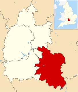
Oxfordshire is a county in South East England. The ceremonial county borders Warwickshire to the north-west, Northamptonshire to the north-east, Buckinghamshire to the east, Berkshire to the south, Wiltshire to the south-west and Gloucestershire to the west.

Abingdon-on-Thames market town in Vale of White Horse, Oxfordshire, England

Abingdon-on-ThamesAB-ing-dən-, known just as Abingdon between 1974 and 2012, is an historic market town and civil parish in the ceremonial county of Oxfordshire, England. Historically the county town of Berkshire, since 1974 Abingdon has been administered by the Vale of White Horse district within Oxfordshire.

South Oxfordshire Non-metropolitan district in England

South Oxfordshire is a local government district in the ceremonial county of Oxfordshire, England. Its council is based in Milton Park, Milton. The areas located south of the River Thames are within the historic county of Berkshire.

Sonning Bridge grade II listed deck arch bridge in the United kingdom

Sonning Bridge is a road bridge across the River Thames at Sonning, Berkshire. It links Sonning with Sonning Eye (Oxfordshire) and crosses the Thames on the reach above Shiplake Lock, just short of Sonning Lock. It is a brick arch bridge completed in 1775, to replace an earlier wooden bridge. The bridge has been the subject of many paintings and prints by artists and is a Grade II listed building.

Thames Path long-distance trail following the River Thames in England

The Thames Path is a National Trail following the River Thames from its source near Kemble in Gloucestershire to the Thames Barrier at Charlton, south east London. It is about 184 miles (296 km) long. A path was first proposed in 1948 but it only opened in 1996.

Clifton Hampden village and civil parish in South Oxfordshire, England

Clifton Hampden is a village and civil parish on the north bank of the River Thames, just over 3 miles (5 km) east of Abingdon in Oxfordshire. Since 1932 the civil parish has included the village of Burcot, 1 mile (1.6 km) east of Clifton Hampden. The 2011 Census recorded the parish population as 662.

Culham Rural District

Culham was a rural district in Oxfordshire, England from 1894 to 1932. It was formed under the Local Government Act 1894 from the part of the Abingdon Rural Sanitary District in the administrative county of Oxfordshire. The remainder of the sanitary district, in the administrative county of Berkshire, became Abingdon Rural District. The rural district council continued to be based at Abingdon, holding meetings in the workhouse of the poor law union.

Remenham village in the United Kingdom

Remenham is a village and civil parish on the Berkshire bank of the River Thames opposite Henley-on-Thames in southern England.

Iffley Lock lock in England

Iffley Lock is a lock on the River Thames in England near the village of Iffley, Oxfordshire. It is on the southern outskirts of Oxford. The original lock was built by the Oxford-Burcot Commission in 1631 and the Thames Navigation Commission replaced this in 1793. The lock has a set of rollers to allow punts and rowing boats to be moved between the water levels.

Abingdon Lock lock on the River Thames in England

Abingdon Lock is a lock on the River Thames in England, less than 1 mile east and upstream of Abingdon, Oxfordshire, on the opposite bank of the river. It was originally built in 1790 by the Thames Navigation Commission.

Burcot, Oxfordshire village in United Kingdom

Burcot is a hamlet in Oxfordshire, England on the left bank of the River Thames, in the civil parish of Clifton Hampden. Until 1932, it lay in the civil parish of Dorchester.

Sailing on the River Thames

Sailing on the River Thames is practised on both the tidal and non-tidal reaches of the river. The highest club upstream is at Oxford. The most popular sailing craft used on the Thames are lasers, GP14s, Wayfarers and Enterprises. One sailing boat unique to the Thames is the Thames Rater, which is sailed around Raven's Ait.

Culham Manor

Culham Manor is a historic manor house in Culham, near Abingdon in southern Oxfordshire, England.

Abbey River river in the United Kingdom

The Abbey River is a right-bank backwater of the River Thames in England, in Chertsey, Surrey — in the town's northern green and blue buffers. The L-shaped conduit adjoins mixed-use flood plain: water-meadows landscaped for a golf course, a motorway and a fresh water treatment works on the island it creates, Laleham Burway to its east and north in turn. Its offtake from the Thames is at the apex of Penton Hook, Staines upon Thames below its lower weir close to the Chertsey-Thorpe boundary in the Borough of Runnymede. Its outfall is the weir pool of Chertsey Lock back into the Thames, visible from Chertsey Bridge. The Environment Agency plans to build similar channels to the upstream Jubilee River, one of which will intersect the watercourse, another of which will be close to its outfall, thereby compensating for loss of its historic bypass functions.

Culham Bridge

Culham Bridge is a mediaeval bridge crossing a present backwater of the River Thames in England at Culham, Oxfordshire, near the town of Abingdon. The bridge crosses Swift Ditch which was at one time the main navigation channel of the River Thames until Abingdon Lock was built in 1790. The bridge formerly carried the A415 road from Abingdon to Dorchester, Oxfordshire, but was superseded in 1928 by a modern road bridge.

Sutton Pools backwater on the course of the River Thames

Sutton Pools are a picturesque backwater formed by a number of weirs, islands, footbridges and barriers on the course of the River Thames at Sutton Courtenay, Oxfordshire, England. The higher level of the river is separated from the lower pools by a causeway which dates from Saxon times. This river stretch ceased to be the main navigable route after Culham Cut was constructed in the early 19th century, which also created an island to the north of the Pools. In addition there are three smaller islands, linked by footbridges over the weirs, part of a footpath between Sutton Courtenay and the village of Culham.

References

  1. OS 25-inch-to-mile map of Oxfordshire of 1897, sheets XLV.16, XXXII.10 and XXXIX.2 published 1898
  2. 1 2 3 4 5 6 'Parishes: Culham', in A History of the County of Oxford: Volume 7, Dorchester and Thame Hundreds, ed. Mary Lobel (London, 1962), pp. 27-39. British History Online http://www.british-history.ac.uk/vch/oxon/vol7/pp27-39 [accessed 16 December 2017].
  3. Chronicon Monasterii de Abingdon, ed. J. Stevenson (2 vols., Rolls Series, 1858)
Next island upstream River Thames Next island downstream
Lock Wood Island Andersey Island Nag's Head Island

Coordinates: 51°40′01″N1°16′12″W / 51.667°N 1.270°W / 51.667; -1.270