
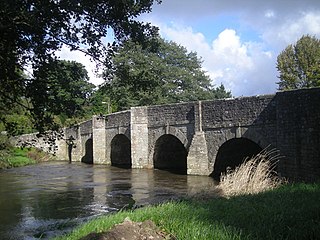
Burway Bridge is a bridge in Ludlow, Shropshire, England. It takes the B4361 road across the River Corve.
Burway Bridge is a bridge in Ludlow, Shropshire, England. It takes the B4361 road across the River Corve.


The original bridge was built in the mid-20th century to take the new Coronation Avenue across the Corve, relieving the historic Corve Bridge just upstream. Before its construction the A49 trunk road crossed Corve Bridge; its construction diverted that route, but consequently meant the less-major A4117 road crossed the Corve Bridge in order to meet the A49. The opening of the A49 Ludlow by-pass in 1979 removed these A roads from the vicinity, with the former A49 route crossing Burway Bridge re-classified as the B4361, which remains to the present day.
The bridge was demolished on 27 June 2007 following heavy rainfall which caused serious flooding of the River Corve resulting in the collapse of the bridge and a neighbouring house.
Undertaken by Shropshire County Council, a temporary Bailey bridge was first opened in August 2007 to partially reopen the B4361. Over the next year, the council's consultants Mouchel designed a permanent bridge and this was constructed by McPhillips (Wellington) Ltd. Constructed to withstand any serious future flooding, the bridge now features a longer span to increase the volume capacity of the River Corve beneath.
The new bridge finally opened on 19 January 2009. (The inscription on the bridge reads "Burway Bridge 2008" as that was the year of its construction.)
The bridge now carries across the river not only two-way road traffic, but also a lane for car parking, a wide cycling & pedestrian pavement on one side of the carriageway, and a pedestrian pavement on the other side.
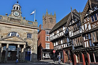
Ludlow is a market town and civil parish in Shropshire, England. It is located 28 miles (45 km) south of Shrewsbury and 23 miles (37 km) north of Hereford, on the A49 road which bypasses the town. The town is near the confluence of the rivers Corve and Teme.

Church Stretton is a market town and civil parish in Shropshire, England, 13 miles (21 km) south of Shrewsbury and 15 miles (24 km) north of Ludlow. The population in 2011 was 4,671.

The M20 is a motorway in Kent, England. It follows on from the A20 at Swanley, meeting the M25, and continuing on to Folkestone, providing a link to the Channel Tunnel and the ports at Dover. It is 50.6 miles (81.4 km) long. Although not signposted in England, this road is part of the European route E15. It is also used as a holding area for goods traffic when traffic across the English Channel is disrupted, such as Operation Stack and Operation Brock.

The River Teme rises in Mid Wales, south of Newtown, and flows southeast roughly forming the border between England and Wales for several miles through Knighton before entering England in the vicinity of Bucknell and continuing east to Ludlow in Shropshire. From there, it flows to the north of Tenbury Wells on the Shropshire/Worcestershire border on its way to join the River Severn south of Worcester. The whole of the River Teme was designated as an SSSI by English Nature in 1996.

The A49 is an A road in western England, which traverses the Welsh Marches region. It runs north from Ross-on-Wye in Herefordshire via Hereford, Leominster, Ludlow, Shrewsbury and Whitchurch, then continues through central Cheshire to Warrington and Wigan before terminating at its junction with the A6 road just south of Bamber Bridge, near the junction of the M6, M65 and M61 motorways.

Known as the Hagley Road in Birmingham, the A456 is a main road in England running between Central Birmingham and Woofferton, Shropshire, south of Ludlow. Some sections of the route, for example Edgbaston near Bearwood, are also the route of the Elan Aqueduct which carries Birmingham's water supply from the Elan Valley.

The A4117 is a single-carriageway 'A road' in western England, largely in Shropshire, which passes through part of the Wyre Forest and Clee Hills.
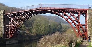
The Iron Bridge is a cast iron arch bridge that crosses the River Severn in Shropshire, England. Opened in 1781, it was the first major bridge in the world to be made of cast iron. Its success inspired the widespread use of cast iron as a structural material, and today the bridge is celebrated as a symbol of the Industrial Revolution.

Church Stretton railway station is a railway station serving the town of Church Stretton in Shropshire, England on the Welsh Marches Line, 12+3⁄4 miles (20.5 km) south of Shrewsbury railway station; trains on the Heart of Wales Line also serve the station. All trains services are operated by Transport for Wales, who also manage the station.

The A5112 is a road in Shropshire, England that runs north–south through the town of Shrewsbury. It runs around the town centre, to the east, and acts as a quicker route through the town than going via the town centre.
Ashford Bowdler is a small village and civil parish in south Shropshire, England, near the county border with Herefordshire.

Bromfield is a village and civil parish in Shropshire, England.
Ludford is a small village and civil parish in south Shropshire, England. The parish is situated adjacent to the market town of Ludlow and was, until 1895, partly in Herefordshire.
The A4113 road is a single-carriageway road that runs from Knighton in Powys to Bromfield in Shropshire, United Kingdom, passing through north Herefordshire.

Hampton Loade Ferry was a pedestrian cable ferry linking the villages of Hampton Loade and Hampton across the River Severn in the English county of Shropshire and providing a link to Hampton Loade village from Hampton Loade station on the heritage Severn Valley Railway, in Hampton village.
Cound Brook is a tributary of the River Severn in Shropshire, England, running to south of the county town Shrewsbury. The Cound Brook rises in the Stretton Hills, and enters the River Severn at Eyton on Severn after winding its way for 22 miles (35 km) across the southern Shropshire-Severn plain. This length is measured from high on the Long Mynd.
National Cycle Network Route 44, part of the National Cycle Network, connects Shrewsbury, Shropshire with Cinderford, Gloucestershire. The part of the route from Shrewsbury to Bromfield is signed - the remainder of the route is currently unsigned.

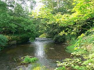
The River Corve is a minor river in Shropshire, England. It is a tributary of the River Teme which it joins in the town of Ludlow, and which joins the River Severn at Powick near Worcester. The valley it flows through is known as the Corvedale, a term used as a general name for the area, and a name used for example by the primary school in Diddlebury. It is sometimes (archaically) spelled "Corf", which is its pronunciation.

During the twenty-four hours before Friday 20 November 2009, rainfall of over 300 mm (12 in) was recorded in Cumbria. Flooding along the Borrowdale and Derwent Valley meant that some areas were up to 8 feet (2.4 m) deep in water. The surge of water off the fells of the Lake District which flowed into Workington down the River Derwent washed away a road bridge and a footbridge. PC Bill Barker was killed when Northside Bridge collapsed. The cemetery at Camerton, historically the burial ground for the community of Seaton, was badly damaged with many gravestones being damaged or upturned.

Tadcaster Bridge or Wharfe Bridge spans the River Wharfe in Tadcaster, North Yorkshire, England. The road bridge is believed to date from around 1700. It is the main route connecting the two sides of the town and one of two road crossings in the town, the other being the bridge for the A64 bypass. Tadcaster Bridge partially collapsed on 29 December 2015 after flooding that followed Storm Eva, and reopened on 3 February 2017.