Barnsley Warren

Last updated

Barnsley Warren
Site of Special Scientific Interest
Pulsatilla vulgaris 'Pasque flower' (Ranunculaceae) flower.jpg
Example - pasqueflower (Pulsatilla vulgaris)
Gloucestershire UK location map.svg
Red pog.svg
Location within Gloucestershire
Location Gloucestershire
Grid reference SP055064
Coordinates 51°45′22″N1°55′18″W / 51.7562°N 1.9217°W / 51.7562; -1.9217
InterestBiological
Area61.3 hectares
Notification 1954
Natural England website

Barnsley Warren (grid reference SP055064 ) is a 61.3-hectare (151-acre) biological Site of Special Scientific Interest in Gloucestershire, notified in 1954 and renotified in 1984. [1] The site is also included in A Nature Conservation Review . It lies in a steep-sided dry valley, east of the A429, northeast of Cirencester in the Cotswolds. [2] The site is listed in the 'Cotswold District' Local Plan 2001-2011 (on line) as a Key Wildlife Site (KWS). [3]

Contents

Following the introduction of the Countryside and Rights of Way Act, the whole of the site was designated "access land" and is therefore open to public access.

There are seven units of assessment and the Gloucestershire Pasqueflower Reserve is unit 4. [4]

Gloucestershire Pasqueflower Reserve

Within the boundary of the Warren, at grid reference SP052071 , is the Gloucestershire Wildlife Trust's Gloucestershire Pasqueflower Reserve which is a 5.3-hectare (13-acre) site. [5] Detailed information is published in the Gloucestershire Wildlife Trust nature reserves handbook. [6]

Pasqueflower (Pulsatilla vulgaris) is found in larger quantities here than anywhere else in the Cotswolds, which are at the western limit of this species' European range. The flowers bloom in late April or early May. The population has been estimated at over twenty thousand plants.

This is a south-west facing slope of Oolitic limestone slope. The thin rendzina soils become richer colluvial deposits in the valley floor. There is a typical Cotswold winterwell in the south-east corner. When this floods in winter it becomes the source of the Ampney Brook.

Other notable plants and species

The Gloucestershire Wildlife Trust reserves handbook lists species. [6] Other notable plants found at the site include man orchid (Aceras anthropophorum), musk orchid (Herminimum monorchis), slender bedstraw (Galium pumilum), chalk milkwort (Polgala calcarea), round-headed rampion (Phyteuma tenerum) and bastard-toadflax (Thesium humifusum). [7]

The diverse range of flowers and grasses is ideal for many downland insects and the reserve has particular good butterfly and bug populations. Recorded are small blue, chalkhill blue and dark green fritillary butterflies and the cydnid shield bug, Sehirus dubius, feeds on the bastard-toadflax. The heath snail, recorded for the site, is an indicator of ancient grassland.

Conservation

The site is grazed to prevent the dominant growth of upright brome and tor-grass. [6]

Plant communities

The plant community in which the pasqueflower grows is CG5 (Bromus erectus - Brachypodium pinnatum grassland) in the British National Vegetation Classification [7]

Related Research Articles

<span class="mw-page-title-main">Cotswold Water Park</span> Lake system and park in England

The Cotswold Water Park is the United Kingdom's largest marl lake system, straddling the Wiltshire–Gloucestershire border, north-west of Cricklade and south of Cirencester. There are 180 lakes, spread over 42 square miles (110 km2).

<span class="mw-page-title-main">Strawberry Banks</span> Biological Site of Special Scientific Interest in Gloucestershire, England

Strawberry Banks is a 5.06-hectare (12.5-acre) biological Site of Special Scientific Interest in Gloucestershire, notified in 1993.

<span class="mw-page-title-main">Ashleworth Ham</span> Biological Site of Special Scientific Interest in Gloucestershire, England

Ashleworth Ham is a 104.73-hectare (258.8-acre) biological Site of Special Scientific Interest. It is a large area of grassland on the Severn floodplain, north of Ashleworth in Gloucestershire, England. It is registered as a Site of Special Scientific Interest and was notified in 1974 and renotified in 1985. Ashleworth Ham received this designation because it is one of three sites in the Severn Vale where migratory waterfowl winter.

<span class="mw-page-title-main">Brassey SSSI</span> Biological Site of Special Scientific Interest in Gloucestershire, England

Brassey is a 2.1-hectare (5.2-acre) biological Site of Special Scientific Interest in Gloucestershire, notified in 1954 and renotified in 1983. It is situated on the north side of the Windrush Valley, midway between Naunton and Upper Slaughter. The reserve comprises sloping, unimproved limestone pasture. There is a fast-flowing stream. This site is one of the few freshwater marshes in Gloucestershire. The stream joins the River Windrush.

<span class="mw-page-title-main">Daneway Banks SSSI</span> Biological Site of Special Scientific Interest in Gloucestershire, England

Daneway Banks is a 17-hectare (42-acre) biological Site of Special Scientific Interest in Gloucestershire, notified in 1954 and renotified in 1983. It lies half a mile west of Sapperton and is part of a group of wildlife sites in the Frome Valley that includes Siccaridge Wood and Sapperton Canal reserves. The site is in the Cotswold Area of Outstanding Natural Beauty.

<span class="mw-page-title-main">Wotton Hill</span> Hill in Gloucestershire, England

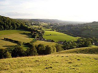
Wotton Hill is a hill on the edge of the Cotswold Hills in Gloucestershire, England, 0.5 miles (0.80 km) north of Wotton-under-Edge. The Cotswold Way passes over the hill.

<span class="mw-page-title-main">Swift's Hill SSSI</span> Geological site in England

Swift's Hill is a 9.15-hectare (22.6-acre) biological and geological Site of Special Scientific Interest in Gloucestershire, notified in 1966 and renotified in 1984.

<span class="mw-page-title-main">Salmonsbury Meadows SSSI</span> English Site of Special Scientific Interest

Salmonsbury Meadows is an 18-hectare (44-acre) biological and geological Site of Special Scientific Interest in Gloucestershire, notified in 1985. The site is listed in the 'Cotswold District' Local Plan 2001-2011 as a Key Wildlife Site (KWS).

<span class="mw-page-title-main">Bourton Down</span>

Bourton Down is an 11.17-hectare (27.6-acre) biological Site of Special Scientific Interest near Bourton-on-the-Hill in Gloucestershire, notified in 1974. The site is listed in the 'Cotswold District' Local Plan 2001–2011 as a Key Wildlife Site (KWS).

<span class="mw-page-title-main">Bull Cross, The Frith and Juniper Hill</span> Site of Special Scientific Interest in Gloucestershire, England

Bull Cross, The Frith and Juniper Hill is a 42.33-hectare (104.6-acre) biological and geological Site of Special Scientific Interest in Gloucestershire, notified in 1954. The site is listed in the ‘Stroud District’ Local Plan, adopted November 2005, Appendix 6 as an SSSI and Regionally Important Geological Site (RIGS).

<span class="mw-page-title-main">Cleeve Common</span>

Cleeve Common is a 455-hectare (1,120-acre) biological and geological Site of Special Scientific Interest in Gloucestershire, England, notified in 1974. It is looked after by a small charity called Cleeve Common Trust, formally Cleeve Common Board of Conservators.

<span class="mw-page-title-main">Cotswold Commons and Beechwoods</span> Biological Site of Special Scientific Interest in Gloucestershire, England

Cotswold Commons and Beechwoods is a 665.5-hectare (1,644-acre) biological Site of Special Scientific Interest in Gloucestershire, notified in 1954.

<span class="mw-page-title-main">Crickley Hill and Barrow Wake</span> Site of Special Scientific Interest in Gloucestershire

Crickley Hill and Barrow Wake is a 56.8-hectare (140-acre) biological and geological Site of Special Scientific Interest in Gloucestershire, notified in 1974.

<span class="mw-page-title-main">Hornsleasow Roughs</span> Biological Site of Special Scientific Interest in Gloucestershire, England

Hornsleasow Roughs is a 28.24-hectare (69.8-acre) biological Site of Special Scientific Interest in Gloucestershire, notified in 1954.

<span class="mw-page-title-main">Leckhampton Hill and Charlton Kings Common</span> Protected area in Gloucestershire, England

Leckhampton Hill and Charlton Kings Common is a 63.8-hectare (158-acre) biological and geological Site of Special Scientific Interest in Gloucestershire, notified in 1954. There are five units of assessment.

<span class="mw-page-title-main">Minchinhampton Common</span> Site of Special Scientific Interest in Gloucestershire

Minchinhampton Common is a 182.7-hectare (451-acre) biological and geological Site of Special Scientific Interest in Minchinhampton, Gloucestershire, England, notified in 1972.

<span class="mw-page-title-main">Puckham Woods</span> Biological Site of Special Scientific Interest in Gloucestershire, England

Puckham Woods is a 32.38-hectare (80.0-acre) biological Site of Special Scientific Interest in Gloucestershire to the east of Cheltenham near Whittington, notified in 1954. The site is listed in the 'Cotswold District' Local Plan 2001-2011 as a Key Wildlife Site (KWS).

<span class="mw-page-title-main">Rodborough Common, Gloucestershire</span> Biological and geological Site of Special Scientific Interest in Gloucestershire, United Kingdom

Rodborough Common is a 116.0-hectare (287-acre) biological and geological Site of Special Scientific Interest in Rodborough, Gloucestershire, England, notified in 1954. The site is listed in the ‘Stroud District’ Local Plan, adopted November 2005, Appendix 6 as an SSSI and a Regionally Important Geological Site (RIGS). The Common is also a Special Area of Conservation (SAC) under the EU Habitats Directive

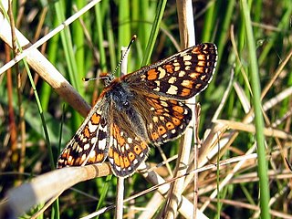
Rough Bank, Miserden is a 9.2-hectare (23-acre) biological Site of Special Scientific Interest in Gloucestershire, notified in 1986. It was purchased by the wildlife charity Butterfly Conservation in 2012.

<span class="mw-page-title-main">Whelford Meadow</span>

Whelford Meadow is a 1.86-hectare (4.6-acre) biological Site of Special Scientific Interest in Gloucestershire, England, notified in 1985.

References

  1. Cotswold District Local Plan, Appendix 1, Sites of Special Scientific Interest Archived March 26, 2012, at the Wayback Machine
  2. Natural England (2009) Sites of Special Scientific Interest (SSSIs) ISBN   978-1-84754-036-2
  3. Cotswold District Local Plan, Appendix 2, Key Wildlife Sites Archived October 13, 2013, at the Wayback Machine
  4. Natural England SSSI information on the Barnsley Warren units
  5. BBC - Breathing Places - Pasqueflower Reserve - Gloucestershire Wildlife Trust [ dead link ] (accessed 11 April 2009)
  6. 1 2 3 Kelham, A, Sanderson, J, Doe, J, Edgeley-Smith, M, et al, 1979, 1990, 2002 editions, 'Nature Reserves of the Gloucestershire Trust for Nature Conservation/Gloucestershire Wildlife Trust'
  7. 1 2 Rodwell, J. S. (editor) 1992, British Plant Communities volume 3, page 182

SSSI source