Cleeve Common

Last updated

Cleeve Common
Site of Special Scientific Interest
Cotswolds Cleeve Common.jpg
Cleeve Common panorama
Gloucestershire UK location map.svg
Red pog.svg
Location within Gloucestershire
Location Gloucestershire
Grid reference SO990260
Coordinates 51°55′59″N2°00′55″W / 51.93296°N 2.015225°W / 51.93296; -2.015225
InterestBiological/Geological
Area455 hectare
Notification 1974
Natural England website

Cleeve Common (grid reference SO990260 ) is a 455-hectare (1,120-acre) biological and geological Site of Special Scientific Interest in Gloucestershire, England, notified in 1974. [1] [2] It is looked after by a small charity called Cleeve Common Trust, formally Cleeve Common Board of Conservators.

Contents

It lies in the Cotswold Area of Outstanding Natural Beauty and is on Cleeve Hill. There is a golf course on the site and the site is registered as a common. The site is on Jurassic limestones on the top of the Cotswold scarp. It is north-east of Cheltenham. It is a large site and is important for its biology and geology. [1]

Biological interest

There are several types of grassland within the site and their origination is dependent upon aspect, soil, grazing intensity and how areas of the common have been managed. The site supports several species of rare orchid such as the bee orchid, the frog orchid and the musk orchid. Spoil and scree from disused quarries provide conditions for plants which grow in more open habitats. [1]

The site supports a wide range of invertebrates. These include butterflies such as the dark green fritillary, grayling and marsh fritillary. The rare snail Abide secale is recorded. [1]

Geological interest

The Bouguetia and phillipsiana beds of the upper Middle Inferior Oolite are confined to a very limited outcrop on Cleeve Common. These units, which have distinctive fossil faunas of bivalves, gastropods and brachiopods, are only visible at Rolling Bank Quarry. These outcrops are thus unique and are considered the only examples of part of the Middle Jurassic, Bajocian, time interval in Britain. The Inferior Oolite hill top of Postlip Warren shows the best example of ridge and trough features. [1]

Pot Quarry and Rolling Bank Quarry are listed as a Regionally Important Geological Site (RIGS). [3] The Cleeve Cloud Fault Section is also so designated.

Related Research Articles

Veizey's Quarry is a 1.4 hectare geological Site of Special Scientific Interest near Tetbury in Gloucestershire, notified in 1974. It is in the Cotswold Area of Outstanding Natural Beauty. The site is listed in the 'Cotswold District' Local Plan 2001-2011 as a Key Wildlife Site (KWS) and a Regionally Important Geological Site (RIGS).

<span class="mw-page-title-main">Selsley</span> Human settlement in England

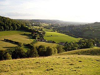
Selsley is a village within the civil parish of King's Stanley and district of Stroud, in Gloucestershire, England. It is composed of around 175 houses, scattered around the western and eastern edge of a Cotswold spur, located approximately 2 miles (3.2 km) south of Stroud.

<span class="mw-page-title-main">Wotton Hill</span> Hill in Gloucestershire, England

Wotton Hill is a hill on the edge of the Cotswold Hills in Gloucestershire, England, 0.5 miles (0.80 km) north of Wotton-under-Edge. The Cotswold Way passes over the hill.

<span class="mw-page-title-main">Bull Cross, The Frith and Juniper Hill</span> Site of Special Scientific Interest in Gloucestershire, England

Bull Cross, The Frith and Juniper Hill is a 42.33-hectare (104.6-acre) biological and geological Site of Special Scientific Interest in Gloucestershire, notified in 1954. The site is listed in the ‘Stroud District’ Local Plan, adopted November 2005, Appendix 6 as an SSSI and Regionally Important Geological Site (RIGS).

<span class="mw-page-title-main">Cotswold Commons and Beechwoods</span> Biological Site of Special Scientific Interest in Gloucestershire, England

Cotswold Commons and Beechwoods is a 665.5-hectare (1,644-acre) biological Site of Special Scientific Interest in Gloucestershire, notified in 1954.

<span class="mw-page-title-main">Crickley Hill and Barrow Wake</span> Site of Special Scientific Interest in Gloucestershire

Crickley Hill and Barrow Wake is a 56.8-hectare (140-acre) biological and geological Site of Special Scientific Interest in Gloucestershire, notified in 1974.

<span class="mw-page-title-main">Haresfield Beacon</span> Geological Site of Special Scientific Interest in Gloucestershire, England

Haresfield Beacon is a 0.73-hectare (1.8-acre) geological Site of Special Scientific Interest in Gloucestershire, notified in 1985. The site is listed in the ‘Stroud District’ Local Plan, adopted November 2005, Appendix 6 as an SSSI and a Regionally Important Geological Site (RIGS).

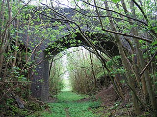
Harford Railway Cutting is a 1.2-hectare (3.0-acre) geological Site of Special Scientific Interest in Gloucestershire, notified in 1974. The site is listed in the 'Cotswold District' Local Plan 2001-2011 as a Regionally Important Geological Site (RIGS).

<span class="mw-page-title-main">Hornsleasow Roughs</span> Biological Site of Special Scientific Interest in Gloucestershire, England

Hornsleasow Roughs is a 28.24-hectare (69.8-acre) biological Site of Special Scientific Interest in Gloucestershire, notified in 1954.

Jackdaw Quarry is a 4.78-hectare (11.8-acre) geological Site of Special Scientific Interest in Gloucestershire, notified in 1985.

<span class="mw-page-title-main">Knap House Quarry, Birdlip</span> Site of Special Scientific Interest in Gloucestershire

Knap House Quarry, Birdlip is a 1.80-hectare (4.4-acre) geological Site of Special Scientific Interest in Gloucestershire, notified in 1974. The site is listed in the 'Cotswold District' Local Plan 2001-2011 as a Key Wildlife Site (KWS) and a Regionally Important Geological Site (RIGS).

<span class="mw-page-title-main">Leckhampton Hill and Charlton Kings Common</span>

Leckhampton Hill and Charlton Kings Common is a 63.8-hectare (158-acre) biological and geological Site of Special Scientific Interest in Gloucestershire, notified in 1954. There are five units of assessment.

<span class="mw-page-title-main">Lineover Wood</span>

Lineover Wood is a 20.3-hectare (50-acre) biological Site of Special Scientific Interest in Gloucestershire, notified in 1986.

<span class="mw-page-title-main">Minchinhampton Common</span> Site of Special Scientific Interest in Gloucestershire

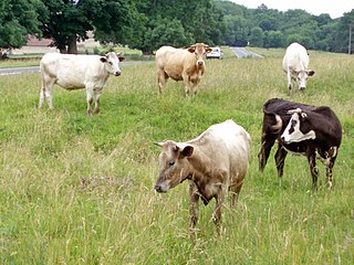
Minchinhampton Common is a 182.7-hectare (451-acre) biological and geological Site of Special Scientific Interest in Gloucestershire, notified in 1972.

<span class="mw-page-title-main">Nibley Knoll</span> Geological Site of Special Scientific Interest in Gloucestershire

Nibley Knoll is a 3.2-hectare (7.9-acre) geological Site of Special Scientific Interest in Gloucestershire, notified in 1974. The site is listed in the ‘Stroud District’ Local Plan, adopted November 2005, Appendix 6 as an SSSI and a Regionally Important Geological Site (RIGS).

<span class="mw-page-title-main">Notgrove Railway Cutting</span>

Notgrove Railway Cutting is a 1.7-hectare (4.2-acre) geological Site of Special Scientific Interest in Gloucestershire, notified in 1974. The site is listed in the 'Cotswold District' Local Plan 2001-2011 as a Key Wildlife Site (KWS) and Regionally Important Geological Site (RIGS).

<span class="mw-page-title-main">Puckham Woods</span> Biological Site of Special Scientific Interest in Gloucestershire, England

Puckham Woods is a 32.38-hectare (80.0-acre) biological Site of Special Scientific Interest in Gloucestershire to the east of Cheltenham near Whittington, notified in 1954. The site is listed in the 'Cotswold District' Local Plan 2001-2011 as a Key Wildlife Site (KWS).

<span class="mw-page-title-main">Rodborough Common, Gloucestershire</span> Biological and geological Site of Special Scientific Interest in Gloucestershire, United Kingdom

Rodborough Common is a 116.0-hectare (287-acre) biological and geological Site of Special Scientific Interest in Gloucestershire, notified in 1954. The site is listed in the ‘Stroud District’ Local Plan, adopted November 2005, Appendix 6 as an SSSI and a Regionally Important Geological Site (RIGS). The Common is also a Special Area of Conservation (SAC) under the EU Habitats Directive

Rough Bank, Miserden is a 9.2-hectare (23-acre) biological Site of Special Scientific Interest in Gloucestershire, notified in 1986. It was purchased by the wildlife charity Butterfly Conservation in 2012.

References

  1. 1 2 3 4 5 "SSSI citation for Cleeve Common" (PDF). Natural England. Archived (PDF) from the original on 25 August 2020. Retrieved 25 August 2020.
  2. "Tewkesbury Borough Local Plan to 2011, adopted March 2006, Appendix 3 'Nature Conservation', Sites of Special Scientific Interest". Archived from the original on 3 March 2016. Retrieved 10 October 2012.
  3. "Tewkesbury Borough Local Plan to 2011, adopted March 2006, Appendix 3 'Nature Conservation', Regionally Important Geological Sites". Archived from the original on 3 March 2016. Retrieved 10 October 2012.

SSSI Source

Commons-logo.svg Media related to Cleeve Common at Wikimedia Commons