Veizey's Quarry is a 1.4 hectare geological Site of Special Scientific Interest near Tetbury in Gloucestershire, notified in 1974. It is in the Cotswold Area of Outstanding Natural Beauty. The site is listed in the 'Cotswold District' Local Plan 2001-2011 as a Key Wildlife Site (KWS) and a Regionally Important Geological Site (RIGS).

Stenders Quarry is a 2.8-hectare (6.9-acre) biological and geological Site of Special Scientific Interest in the Forest of Dean, Gloucestershire, England, notified in 1966 and renotified in 1990. The site is designated as an SSSI for its important geological features, although there is also a diversity of plants and animals recorded.

Wotton Hill is a hill on the edge of the Cotswold Hills in Gloucestershire, England, 0.5 miles (0.80 km) north of Wotton-under-Edge. The Cotswold Way passes over the hill.

Bull Cross, The Frith and Juniper Hill is a 42.33-hectare (104.6-acre) biological and geological Site of Special Scientific Interest in Gloucestershire, notified in 1954. The site is listed in the ‘Stroud District’ Local Plan, adopted November 2005, Appendix 6 as an SSSI and Regionally Important Geological Site (RIGS).
Campden Tunnel Gravel Pit is a 0.2-hectare (0.49-acre) geological Site of Special Scientific Interest in Gloucestershire, notified in 1988. The site is listed in the 'Cotswold District' Local Plan 2001-2011.

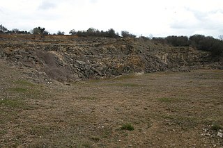
Coaley Wood Quarries is a 4.85-hectare (12.0-acre) geological Site of Special Scientific Interest in Gloucestershire, notified in 1974.

Crickley Hill and Barrow Wake is a 56.8-hectare (140-acre) biological and geological Site of Special Scientific Interest in Gloucestershire, notified in 1974.
Foss Cross Quarry is a 0.67-hectare (1.7-acre) geological Site of Special Scientific Interest in Gloucestershire, notified in 1972. The site is listed in the 'Cotswold District' Local Plan 2001-2011 as a Key Wildlife Site (KWS) and a Regionally Important Geological Site (RIGS).
Hampen Railway Cutting is a 3.9-hectare (9.6-acre) geological Site of Special Scientific Interest in Gloucestershire, notified in 1974. The site is listed in the 'Cotswold District' Local Plan 2001-2011 as a Key Wildlife Site (KWS) and Regionally Important Geological Site (RIGS).
Harford Railway Cutting is a 1.2-hectare (3.0-acre) geological Site of Special Scientific Interest in Gloucestershire, notified in 1974. The site is listed in the 'Cotswold District' Local Plan 2001-2011 as a Regionally Important Geological Site (RIGS).
Hornsleasow Quarry is a 3.5-hectare (8.6-acre) geological Site of Special Scientific Interest in Gloucestershire, notified in 1974. The site is listed in the 'Cotswold District' Local Plan 2001-2011 as a Regionally Important Geological Site (RIGS).

Huntsman's Quarry is a 1.6-hectare (4.0-acre) geological Site of Special Scientific Interest in Gloucestershire, notified in 1974. The site is listed in the 'Cotswold District' Local Plan 2001-2011 as a Key Wildlife Site (KWS) and a Regionally Important Geological Site (RIGS).
Kemble Railway Cuttings is a 2.72-hectare (6.7-acre) geological Site of Special Scientific Interest in Gloucestershire, England, notified in 1996. The site is listed in the Cotswold District Local Plan 2001–2011 as a Regionally Important Geological Site (RIGS).

Knap House Quarry, Birdlip is a 1.80-hectare (4.4-acre) geological Site of Special Scientific Interest in Gloucestershire, notified in 1974. The site is listed in the 'Cotswold District' Local Plan 2001-2011 as a Key Wildlife Site (KWS) and a Regionally Important Geological Site (RIGS).
Land Grove Quarry, Mitcheldean is a 3.8-hectare (9.4-acre) geological Site of Special Scientific Interest in Gloucestershire, England, notified in 1974. The site is listed in the 'Forest of Dean Local Plan Review' as a Key Wildlife Site (KWS).

Leckhampton Hill and Charlton Kings Common is a 63.8-hectare (158-acre) biological and geological Site of Special Scientific Interest in Gloucestershire, notified in 1954. There are five units of assessment.
New Park Quarry is a 1.3-hectare (3.2-acre) geological Site of Special Scientific Interest in Gloucestershire, notified in 1987. The site is listed in the 'Cotswold District' Local Plan 2001-2011 as a Regionally Important Geological Site (RIGS).
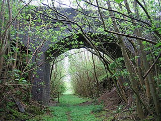
Notgrove Railway Cutting is a 1.7-hectare (4.2-acre) geological Site of Special Scientific Interest in Gloucestershire, notified in 1974. The site is listed in the 'Cotswold District' Local Plan 2001-2011 as a Key Wildlife Site (KWS) and Regionally Important Geological Site (RIGS).
Puddlebrook Quarry is a 0.7-hectare (1.7-acre) geological Site of Special Scientific Interest in Gloucestershire, near Drybrook notified in 1986. The site is listed in the 'Forest of Dean Local Plan Review' as a Key Wildlife Site (KWS).
Stony Furlong Railway Cutting is a 2.7-hectare (6.7-acre) geological Site of Special Scientific Interest in Gloucestershire, notified in 1987. The site is listed in the 'Cotswold District' Local Plan 2001-2011 as a Key Wildlife Site (KWS) and a Regionally Important Geological Site (RIGS).
