Wainlode Cliff

Last updated

Contents

Wainlode Cliff
Site of Special Scientific Interest
River Severn at Wainlode Cliff - geograph.org.uk - 592637.jpg
Wainlode Cliff
Gloucestershire UK location map.svg
Red pog.svg
Location within Gloucestershire
Location Gloucestershire
Grid reference SO845257
Coordinates 51°55′48″N2°13′34″W / 51.930046°N 2.226104°W / 51.930046; -2.226104 Coordinates: 51°55′48″N2°13′34″W / 51.930046°N 2.226104°W / 51.930046; -2.226104
InterestGeological
Area1.3 hectare
Notification 1954
Natural England website

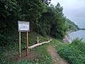
Wainlode Cliff (grid reference SO845257 ) is a 1.3 hectare geological Site of Special Scientific Interest in Gloucestershire, notified in 1954. [1] [2] It overlooks Hasfield Ham.

Geology

This an historic locality which was first described in 1842 and shows a seven-metre section of Rhaetian age. The site mains the regional two-fold division of Westbury and Cotham Beds. The Insect Limestone, which is a productive source of insects, defines the base of the Lias. [1]

Fishing

Seasonal fishing is permitted on the riverbank beneath the cliff. Day tickets are available from the campsite shop, currently priced at £5 per day (2022).

Wikipedia Fishing.jpg


Sources

Related Research Articles

Site of Special Scientific Interest Conservation designation denoting a protected area in the United Kingdom

A Site of Special Scientific Interest (SSSI) in Great Britain or an Area of Special Scientific Interest (ASSI) in the Isle of Man and Northern Ireland is a conservation designation denoting a protected area in the United Kingdom and Isle of Man. SSSI/ASSIs are the basic building block of site-based nature conservation legislation and most other legal nature/geological conservation designations in the United Kingdom are based upon them, including national nature reserves, Ramsar sites, Special Protection Areas, and Special Areas of Conservation. The acronym "SSSI" is often pronounced "triple-S I".

Workmans Wood, Sheepscombe

Workmans Wood is a wood just to the east of the village of Sheepscombe, in the Cotswolds, Gloucestershire. It is a biological Site of Special Scientific Interest being part of the Cotswold Commons And Beechwoods SSSI. The Wood is part of a designated national nature reserve (NNR).

Sylvan House Barn

Sylvan House Barn is a 0.005-hectare (0.012-acre) stone built barn near the village of St Briavels, in the Forest of Dean, Gloucestershire. Because of its breeding bats, the site was notified as a biological Site of Special Scientific Interest in 1995.

Veizeys Quarry

Veizey's Quarry is a 1.4 hectare geological Site of Special Scientific Interest near Tetbury in Gloucestershire, notified in 1974. It is in the Cotswold Area of Outstanding Natural Beauty. The site is listed in the 'Cotswold District' Local Plan 2001-2011 as a Key Wildlife Site (KWS) and a Regionally Important Geological Site (RIGS).

Wellacre Quarry

Wellacre Quarry is a 12.3 hectare geological Site of Special Scientific Interest in Gloucestershire, notified in 1974. It is within the Cotswold Area of Outstanding Natural Beauty and the site was formerly known as Blockley Station Brickworks. The site is listed in the 'Cotswold District' Local Plan 2001-2011 as a Key Wildlife Site (KWS) and a Regionally Important Geological Site (RIGS).

Ashleworth Ham Biological Site of Special Scientific Interest in Gloucestershire, England

Ashleworth Ham is a 104.73-hectare (258.8-acre) biological Site of Special Scientific Interest. It is a large area of grassland on the Severn floodplain, north of Ashleworth in Gloucestershire, England. It is registered as a Site of Special Scientific Interest and was notified in 1974 and renotified in 1985. Ashleworth Ham received this designation because it is one of three sites in the Severn Vale where migratory waterfowl winter.

Alderton Hill Quarry

Alderton Hill Quarry is a 0.34-hectare (0.84-acre) geological Site of Special Scientific Interest in Gloucestershire, notified in 1997. It is a Geological Conservation Review (GCR) site.

Blaisdon Hall

Blaisdon Hall is a Grade II* listed building at Blaisdon. It includes a 0.07-hectare (0.17-acre) biological Site of Special Scientific Interest in Gloucestershire, notified in 1995.

Devils Chapel Scowles Biological Site of Special Scientific Interest in Gloucestershire, England

Devil's Chapel Scowles is a 44.79-hectare (110.7-acre) biological Site of Special Scientific Interest in Gloucestershire, notified England, in 1998. The site lies in the Forest of Dean and has four units of assessment by Natural England.

Garden Cliff Geological Site of Special Scientific Interest in Gloucestershire, England

Garden Cliff is a 5.1-hectare (13-acre) geological Site of Special Scientific Interest in Gloucestershire, notified in 1954.

Hornsleasow Roughs Biological Site of Special Scientific Interest in Gloucestershire, England

Hornsleasow Roughs is a 28.24-hectare (69.8-acre) biological Site of Special Scientific Interest in Gloucestershire, notified in 1954.

Hucclecote Meadows

Hucclecote Meadows is a 5.74-hectare (14.2-acre) biological Site of Special Scientific Interest divided into two areas on each side of the M5 road in the Severn Vale, Gloucestershire. It was notified in 1984. The western area is also a Local Nature Reserve.

Leckhampton Hill and Charlton Kings Common

Leckhampton Hill and Charlton Kings Common is a 63.8-hectare (158-acre) biological and geological Site of Special Scientific Interest in Gloucestershire, notified in 1954. There are five units of assessment.

Lydney Cliff

Lydney Cliff is a 8.0-hectare (20-acre) geological Site of Special Scientific Interest in Gloucestershire, notified in 1990. Part of the site is included in the Severn Estuary SSSI.

Old Bow and Old Ham Mines

Old Bow And Old Ham Mines is a 40.3-hectare (100-acre) biological Site of Special Scientific Interest in Gloucestershire, notified in 1998.

Severn Ham, Tewkesbury

Severn Ham, Tewkesbury is a 70.82-hectare (175.0-acre) biological Site of Special Scientific Interest in Gloucestershire near Tewkesbury, notified in 1974.

Westbury Brook Ironstone Mine

Westbury Brook Ironstone Mine is a 15.69-hectare (38.8-acre) biological Site of Special Scientific Interest in Gloucestershire, notified in 1998.

Wigpool Ironstone Mine

Wigpool Ironstone Mine is a 34.88-hectare (86.2-acre) biological Site of Special Scientific Interest in Gloucestershire, notified in 1998.

Crouch and Roach Estuaries

The Crouch and Roach Estuaries are a 1729 hectare biological Site of Special Scientific Interest (SSSI) at the mouth of the Crouch and Roach rivers in Essex. The Crouch part of the SSSI stretches from near Battlesbridge to Foulness Island, and the Roach from Rochford to the junction with the Crouch. Part of the site is in the Mid-Essex Coast Special Protection Area under the EC Directive on the Conservation of Wild Birds, and a Ramsar wetland site of international importance. It is also part of the Essex Estuaries Special Area of Conservation. An area of 65 hectares is managed by the Essex Wildlife Trust as the Lion Creek and Lower Raypits nature reserve and 8 hectares at Woodham Fen, both of which are managed by the Essex Wildlife Trust. A small area is also a geological SSSI, The Cliff, Burnham-on-Crouch.

References

  1. 1 2 Natural England SSSI information on citation, map and unit details
  2. Tewkesbury Borough Local Plan to 2011, adopted March 2006, Appendix 3 'Nature Conservation', Sites of Special Scientific Interest