Dolebury Warren

Last updated

Dolebury Warren
Native name
Dolebury Camp
Doleburyhillfort.jpg
Location Churchill, Somerset
Coordinates 51°19′39″N2°47′01″W / 51.32750°N 2.78361°W / 51.32750; -2.78361
Governing body Avon Wildlife Trust
Owner National Trust
Official nameDolebury Camp
Designated19 December 1929 [1]
Reference no.1008184
Somerset UK location map.svg
Red pog.svg
Location of Dolebury Warren in Somerset

Dolebury Warren (also known as Dolebury Camp) is a 90.6 hectares (224 acres) biological Site of Special Scientific Interest (SSSI) and ancient monument near the villages of Churchill and Rowberrow in North Somerset, part of South West England. It is owned by the National Trust, who acquired the freehold in 1983, and managed by the Avon Wildlife Trust.

Contents

Standing on a limestone ridge on the northern edge of the Mendip Hills, it was made into a hill fort during the Iron Age and was occupied into the Roman period. The extensive fort covers 9.1 hectares (22 acres) with single or double defensive ramparts around it. The name Dolebury Warren comes from its use during the medieval or post medieval periods as a rabbit warren. The topography and differing soil types provide a habitat for an unusually wide range of plants, attracting a variety of insects, including several species of butterfly.

Geology and location

The site is at the top of a Carboniferous Limestone ridge on the northern edge of the Mendip Hills. It forms part of the Black Down Pericline where the limestone has been exposed because of erosion of the overlying Triassic dolomitic conglomerate. [2] [3] The soil depth varies considerably, owing to the slope within the site and the effects of its exposure to the wind. [4]

Dolebury Warren overlooks the villages of Churchill and Rowberrow and provides good visibility across the surrounding lower lying areas as far as the Bristol Channel. The highest point, at the eastern end of the site is 183 metres (600 ft) OD, with the hillfort being up to 50 metres (160 ft) below this. [5] It is the starting point for the Limestone Link, a 36-mile (58 km) long-distance footpath which ends at Cold Ashton in Gloucestershire. [6]

Description

The fort covers an area of 9.1 hectares (22 acres) and commands views over the surrounding countryside. [7] The hill fort is bivallate on three sides and a single rampart on the southern side which is protected by a steep slope. [8] It is almost rectangular with the longest axis from east to west being 487 metres (1,598 ft) long and 200 metres (660 ft) from north to south, surrounded by a rampart which is around 4 metres (13 ft) high and 12 metres (39 ft) wide. [9] It was protected by a limestone rampart with a ditch and counterscarp on all sides but the south. There is an inturned entrance on the west and an annexe of 0.4 hectares (0.99 acres) protecting the easier eastern approach. [10]

History

Etymology

The name Dolebury may mean the idol hill from the Old English dwol and beorg. [11]

Early

Earthworks at Dolebury Warren Dolebury Camp Somerset Map.jpg
Earthworks at Dolebury Warren
The southern ramparts Dolebury Hillfort southern ramparts - geograph.org.uk - 593107.jpg
The southern ramparts

Various artefacts have been uncovered representing the long period of occupation of the site at Dolebury Warren. These include flintwork from the Palaeolithic, bronze spearheads, Bronze Age pottery, and Roman pottery and coins. [9] [12] There is evidence of occupation of the site during the Iron Age. [13] The defences and Celtic field systems there date back to the 7th century−3rd century BCE, though they might mask earlier developments. [14] [15] The hillfort was occupied until approximately 100BC, though it is possible that it was reoccupied in the Roman and post-Roman periods. [15] The archeological consultant Peter Leach has suggested there may even have been a Roman Temple built within the hillfort, [16] while aerial photographs suggest the probable remains of an Iron Age or Roman coaxial field system. [17] [18] Local historian Robin Atthill also suggests that Dolebury may have re-emerged as an important centre of population in the 5th century. [19]

Looking east towards the highest point Dolebury Iron Age Hillfort - geograph.org.uk - 593105.jpg
Looking east towards the highest point

Medieval

In the medieval or post-medieval period, the remains of the hillfort were used as a rabbit warren which was used to breed rabbits, providing valuable meat and fur. Many warrens were surrounded by banks or walls to prevent the rabbits from escaping; escaped rabbits caused damage to nearby farmland and meant a loss in profit. [20] The warren at Dolebury is completely enclosed by the substantial ramparts of the Iron Age hill fort and thus provided an ideal location to breed rabbits. The presence of pillow mounds and vermin traps demonstrate management of the site for husbandry. [21] Ridge and furrow agriculture has also been identified, from aerial photographs, within the fort. [22] Some of these structures, along with earlier Iron Age features, have been damaged by subsequent quarrying which may have been for lead, ochre or calamine. [23] [24] The site was described by John Leland in the 16th century. [25] A three-storey building, believed to be the warrener's house and possibly a watch tower, surrounded by a garden, was in ruins by 1830. [26] [27]

Dolebury Warren 30 minutes after sunrise looking east by northeast showing the northern, eastern, and southern ramparts. Photograph taken January 2024. Dolebury Warren.jpg
Dolebury Warren 30 minutes after sunrise looking east by northeast showing the northern, eastern, and southern ramparts. Photograph taken January 2024.

19th and 20th centuries

The site was visited in the early 19th century by John Skinner and surveyed in 1872 by Charles William Dymond. [12] In 1906 the Mendip Lodge Estate, which included Dolebury Warren, was sold. [28] It was first scheduled as an ancient monument in 1929. [9] [29] In 1935 Dolebury Camp was bought by Miss V. Wills of the W.D. & H.O. Wills tobacco company to prevent development. [30] Dolebury Warren was notified as a Site of Special Scientific Interest in 1952. [31] The freehold of 92.657 hectares (228.96 acres) was acquired by the National Trust in 1983 from A. G. Gosling, D. F. Gosling and J. M. Kent, and is managed by the Avon Wildlife Trust. [32] [33]

Ecology

Dolebury Warren
Site of Special Scientific Interest
Dolebury Warren 02.JPG
Location Avon
InterestBiological
Area90.6 hectares (0.906 km2; 0.350 sq mi)
Notification 1952
Natural England website

The site of the fort and warren is now grassy slopes which attract a wide range of wild flowers and butterflies. [34] The differing soil types provide suitable habitats for both acid- and lime-loving plants. [4] Kidney vetch (Anthyllis vulneraria), harebell (Campanula rotundifolia) and woolly thistle (Cirsium eriophorum) thrive on the dry stony soils. Heath bedstraw (Galium saxatile) and wood sage (Teucrium scorodonia) are found in more acidic areas. The higher areas support bell heather (Erica cinerea), western gorse (Ulex gallii) and common heather (Calluna vulgaris). Trees and shrubs include the wayfaring tree (Viburnum lantana), guelder rose (Viburnum opulus), whitebeam (Sorbus aria), privet (Ligustrum vulgare) and dogwood (Cornus sanguinea). [31]

Scarce plants found at the warren include knotted pearlwort (Sagina nodosa), [35] and slender bedstraw (Galium pumilum). [36] Butterflies recorded here include the small blue (Cupido minimus), marbled white (Melanargia galathea), dingy skipper (Erynnis tages), grizzled skipper (Pyrgus malvae), small pearl-bordered fritillary (Boloria selene), and wall brown (Lasiommata megera). [34] [37]

See also

Related Research Articles

<span class="mw-page-title-main">Solsbury Hill</span> Iron Age hillfort in Somerset, England

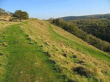
Little Solsbury Hill is a small flat-topped hill and the site of an Iron Age hill fort, above the village of Batheaston in Somerset, England. The hill rises to 625 feet (191 m) above the River Avon, which is just over 1 mile (2 km) to the south, and gives views of the city of Bath and the surrounding area. It is within the Cotswolds Area of Outstanding Natural Beauty.

<span class="mw-page-title-main">Brean Down</span> Promontory in Somerset, England

Brean Down is a promontory off the coast of Somerset, England, standing 318 feet (97 m) high and extending 1+12 miles into the Bristol Channel at the eastern end of Bridgwater Bay between Weston-super-Mare and Burnham-on-Sea.

<span class="mw-page-title-main">Small Down Knoll</span> Bronze Age hillfort in Somerset, England

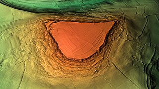
Small Down Knoll, or Small Down Camp, is a Bronze Age hill fort near Evercreech in Somerset, England. The hill is on the southern edge of the Mendip Hills, and rises to 222 m (728 ft).

<span class="mw-page-title-main">Dunkery Hill</span> Summit of Dunkery Hill

Dunkery Beacon at the summit of Dunkery Hill is the highest point on Exmoor and in Somerset, England. It is also the highest point in southern England outside of Dartmoor.

<span class="mw-page-title-main">Cadbury Camp</span> Iron Age hillfort in Somerset, England

Cadbury Camp is an Iron Age hill fort in Somerset, England, near the village of Tickenham. It is a scheduled monument. Although primarily known as a fort during the Iron Age it is likely, from artefacts, including a bronze spear or axe head, discovered at the site, that it was first used in the Bronze Age and still occupied through the Roman era into the sub-Roman period when the area became part of a Celtic kingdom. The name may mean "Fort of Cador" - Cado(r) being possibly the regional king or warlord controlling Somerset, Bristol, and South Gloucestershire, in the middle to late 5th century. Cador has been associated with Arthurian England, though the only evidence for this is the reference in the Life of St. Carantoc to Arthur and Cador ruling from Dindraithou and having the power over western Somerset to grant Carantoc's plea to build a church at Carhampton. Geoffrey of Monmouth invented the title 'Duke of Cornwall' for Cador in his misleading History of the Kings of Britain.

<span class="mw-page-title-main">Worlebury Hill</span>

Worlebury Hill is the name given to an upland area lying between the flatlands of Weston-super-Mare and the Kewstoke area of North Somerset, England. Worlebury Hill's rises from sea level to its highest point of 109 metres (358 ft), and the western end of the hill forms a peninsula, jutting out into the Bristol Channel, between Weston Bay and Sand Bay. A toll road follows the coast around the hill from Sand Bay in the north to the now derelict Birnbeck Pier in the west, although tolls are not currently collected on the road. Worlebury Golf Club is situated on the Hill and the area is known for being one of the wealthiest areas in the county of Somerset.

<span class="mw-page-title-main">Maesbury Castle</span> Iron Age hillfort in Somerset, England

Maesbury Castle is an Iron Age hill fort within the parish of Croscombe on the Mendip Hills, just north of Shepton Mallet, Somerset, England. It has been listed as a Scheduled Ancient Monument.

<span class="mw-page-title-main">Midsummer Hill</span>

Midsummer Hill is situated in the range of Malvern Hills that runs approximately 13 kilometres (8 mi) north-south along the Herefordshire-Worcestershire border. It lies to the south of Herefordshire Beacon with views to Eastnor Castle. It has an elevation of 284 metres (932 ft). To the north is Swinyard Hill. It is the site of an Iron Age hill fort which spans Midsummer Hill and Hollybush Hill. The hillfort is protected as a Scheduled Ancient Monument and is owned by Natural England. It can be accessed via a footpath which leads south from the car park at British Camp on the A449 or a footpath which heads north from the car park in Hollybush on the A438.
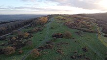
<span class="mw-page-title-main">Scratchbury Camp</span> Iron Age hillfort in Wiltshire, England

Scratchbury Camp is the site of an Iron Age univallate hillfort on Scratchbury Hill, overlooking the Wylye valley about 1 km northeast of the village of Norton Bavant in Wiltshire, England. The fort covers an area of 37 acres (15 ha) and occupies the summit of the hill on the edge of Salisbury Plain, with its four-sided shape largely following the natural contours of the hill.

<span class="mw-page-title-main">Brent Knoll Camp</span> Iron Age hillfort in Somerset, England

Brent Knoll Camp is an Iron Age hillfort at Brent Knoll, 3 kilometres (1.9 mi) from Burnham-on-Sea, Somerset, England. It has been designated as a Scheduled Monument, and is now in the care of the National Trust.

<span class="mw-page-title-main">Dinedor Camp</span>

Dinedor Camp is an Iron Age hillfort, about 1 kilometre (0.6 mi) west of the village of Dinedor and about 3 kilometres (1.9 mi) south of Hereford in England. It is a scheduled monument.

<span class="mw-page-title-main">Scheduled monuments in Bath and North East Somerset</span>

Bath and North East Somerset is a unitary authority created on 1 April 1996, following the abolition of the County of Avon, which had existed since 1974. Part of the ceremonial county of Somerset, Bath and North East Somerset occupies an area of 220 square miles (570 km2), two-thirds of which is green belt. It stretches from the outskirts of Bristol, south into the Mendip Hills and east to the southern Cotswold Hills and Wiltshire border. The city of Bath is the principal settlement in the district, but BANES also covers Keynsham, Midsomer Norton, Radstock and the Chew Valley. The area has a population of 170,000, about half of whom live in Bath, making it 12 times more densely populated than the rest of the area.

<span class="mw-page-title-main">Scheduled monuments in Mendip</span>

Mendip is a local government district of Somerset in England. The Mendip district covers a largely rural area of 285 square miles (738 km2) ranging from the Mendip Hills through on to the Somerset Levels. It has a population of approximately 110,000. The administrative centre of the district is Shepton Mallet but the largest town is Frome.

<span class="mw-page-title-main">Scheduled monuments in Somerset</span> Nationally important sites in Somerset, England

There are over 670 scheduled monuments in the ceremonial county of Somerset in South West England. The county consists of a non-metropolitan county, administered by Somerset Council. The two administratively independent unitary authorities, which were established on 1 April 1996 following the breakup of the county of Avon, are North Somerset and Bath and North East Somerset. These unitary authorities include areas that were once part of Somerset before the creation of Avon in 1974.

<span class="mw-page-title-main">Wadbury Camp</span> Promontory fort in Somerset, England

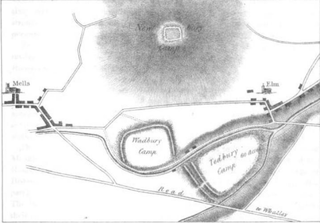
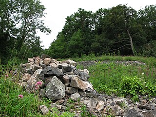
Wadbury Camp is a promontory fort in Somerset, England that protected the mining district of the Mendip Hills in pre-Roman times. It seems to have been an outwork of the larger Tedbury Camp.

Dungeon Hill is an Iron Age hillfort, about 1+14 miles north of the village of Buckland Newton in Dorset, England. It is a scheduled monument.

<span class="mw-page-title-main">Banbury Hill</span> Iron Age hillfort in Dorset, England

Banbury Hillfort, or Banbury Hill Camp, is an Iron Age hillfort, about 1.25 miles (2.0 km) south of Sturminster Newton and 1 mile (1.6 km) north-west of the village of Okeford Fitzpaine in Dorset, England.

References

  1. Historic England. "Dolebury Camp: a large univallate hillfort and associated and later earthworks on Dolebury Warren (1008184)". National Heritage List for England . Retrieved 9 September 2014.
  2. "Banwell to Churchill". British Geological Survey. Retrieved 23 August 2014.
  3. Farrant 2008, p. 47.
  4. 1 2 Atthill 1976, p. 42.
  5. Bowden 2009, pp. 1–3.
  6. "Limestone Link (Cotswolds to Mendips)". Long Distance Walkers Association. Retrieved 24 August 2014.
  7. Dyer 2001, p. 156.
  8. "Dolebury Camp Hillfort, Somerset". Digital Digging. Retrieved 23 August 2014.
  9. 1 2 3 Historic England. "Dolebury Camp: a large univallate hillfort and associated and later earthworks on Dolebury Warren (1008184)". National Heritage List for England. Retrieved 23 August 2014.
  10. "Dolebury". Roman Britain. Archived from the original on 13 June 2010. Retrieved 14 November 2010.
  11. Robinson, Stephen (1992). Somerset Place Names. Wimbourne: The Dovecote Press Ltd. p. 56. ISBN   978-1874336037.
  12. 1 2 Bowden 2009, p. 3.
  13. "Mendip Hills An Archaeological Survey of the Area of Outstanding Natural Beauty" (PDF). Somerset County Council Archeological Projects. Retrieved 16 January 2011.
  14. "Tower Head and Dolebury Warren". Isle of Avalon. Retrieved 28 October 2006.
  15. 1 2 Bowden 2009, p. 13.
  16. Leach 2001, p. 100.
  17. Historic England. "Monument No. 1494935". Research records (formerly PastScape). Retrieved 24 August 2014.
  18. Aston & Burrow 1991, p. 85.
  19. Atthill 1976, p. 73.
  20. Williamson 2006.
  21. Atthill 1976, p. 92.
  22. Historic England. "Monument No. 1494886". Research records (formerly PastScape). Retrieved 24 August 2014.
  23. Bowden 2009, p. 17.
  24. Historic England. "Monument No. 1494887". Research records (formerly PastScape). Retrieved 24 August 2014.
  25. Bowden 2009, p. 4.
  26. Bowden 2009, pp. 7–11.
  27. Historic England. "Monument No. 1494857". Research records (formerly PastScape). Retrieved 24 August 2014.
  28. "Sale of Mendip Lodge" . Western Times. 14 September 1906. Retrieved 23 August 2014 via British Newspaper Archive.
  29. Historic England. "Dolebury Camp (194279)". Research records (formerly PastScape). Retrieved 16 March 2011.
  30. "Dolbury Camp Saved" . Bath Chronicle and Weekly Gazette. 24 August 1935. Retrieved 23 August 2014 via British Newspaper Archive.
  31. 1 2 "SSSI citation sheet for Dolebury Warren" (PDF). English Nature. Archived from the original (PDF) on 3 March 2016. Retrieved 23 August 2014.
  32. "Acquisitions Up to December 2011". National Trust. Archived from the original on 14 July 2014. Retrieved 24 August 2014.
  33. "Mendip Hills. Things to see and do". National Trust. Retrieved 24 August 2014.
  34. 1 2 "Dolebury Warren". Avon Wildlife Trust. Retrieved 23 August 2014.
  35. Myles 2000, p. 81.
  36. Myles 2000, p. 191.
  37. "Sites for National Grid Square: ST". UK Butterflies. Retrieved 24 August 2014.

Bibliography