Related Research Articles
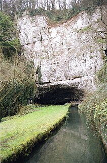
Wookey Hole Caves are a series of limestone caverns, a show cave and tourist attraction in the village of Wookey Hole on the southern edge of the Mendip Hills near Wells in Somerset, England. The River Axe flows through the cave. It is a Site of Special Scientific Interest (SSSI) for both biological and geological reasons. Wookey Hole cave is a "solutional cave", one that is formed by a process of weathering in which the natural acid in groundwater dissolves the rocks. Some water originates as rain that flows into streams on impervious rocks on the plateau before sinking at the limestone boundary into cave systems such as Swildon's Hole, Eastwater Cavern and St Cuthbert's Swallet; the rest is rain that percolates directly through the limestone. The temperature in the caves is a constant 11 °C (52 °F).

The Mendip Hills is a range of limestone hills to the south of Bristol and Bath in Somerset, England. Running from Weston-super-Mare and the Bristol Channel in the west to the Frome valley in the east, the hills overlook the Somerset Levels to the south and the Chew Valley and other tributaries of the Avon to the north. The hills give their name to the local government district of Mendip, which administers most of the area. The higher, western part of the hills, covering 198 km2 (76 sq mi) has been designated an Area of Outstanding Natural Beauty (AONB), which gives it a level of protection comparable to a national park.

Axbridge is a small town in Somerset, England, in the Sedgemoor district on the River Axe, near the southern edge of the Mendip Hills. The town's population according to the 2011 census was 2,057.
The River Axe is a river in South West England. The river is formed by water entering swallets in the limestone and rises from the ground at Wookey Hole Caves in the Mendip Hills in Somerset, and runs through a V-shaped valley. The geology of the area is limestone and the water reaches Wookey Hole in a series of underground channels that have eroded through the soluble limestone. The river mouth is in Weston Bay on the Bristol Channel.

Shipham is a village and civil parish in Somerset, England. It is on the western edge of the Mendip Hills near the A38, approximately 15 miles (24 km) south of Bristol. It is in the local government district of Sedgemoor. The parish includes the village of Rowberrow and the hamlet of Star. The parish population, according to the 2011 census, is 1,087.
Banwell Caves are a 1.7-hectare geological and biological Site of Special Scientific Interest near the village of Banwell, North Somerset, England notified in 1963.

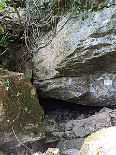
Compton Martin Ochre Mine is a 0.85 hectare geological and biological Site of Special Scientific Interest located on the north side of the Mendip Hills, immediately south west of Compton Martin village, Somerset, notified in 1988.
Lamb Leer is a 14.59 hectare geological Site of Special Scientific Interest between East Harptree and Priddy in the Mendip Hills, Somerset, notified in 1983. The cavern is a fragment of a very ancient major cave system which now contains one of the largest chambers in the Mendip Hills.

Axbridge Hill and Fry's Hill is a 64.8-hectare (160-acre) biological Site of Special Scientific Interest in the Mendip Hills, Somerset, notified in 1990. The hills are above the town of Axbridge, immediately to the east of Shute Shelve Hill.

Crook Peak to Shute Shelve Hill is a 332.2 hectare (820.9 acre) geological and biological Site of Special Scientific Interest near the western end of the Mendip Hills, Somerset. The line of hills runs for approximately 5 kilometres (3.1 mi) from west to east and includes: Crook Peak, Compton Hill, Wavering Down, Cross Plain and Shute Shelve Hill. Most of the site is owned by the National Trust, which bought 725 acres (293 ha) in 1985, and much of it has been designated as common land. It was notified as an SSSI by Natural England in 1952.

The Cheddar Complex is a 441.3 hectare biological Site of Special Scientific Interest near Cheddar around the Cheddar Gorge and north east to Charterhouse in the Mendip Hills, Somerset, England, notified in 1952.
Compton Bishop is a small village and civil parish, at the western end of the Mendip Hills in the English county of Somerset. It is located close to the historic town of Axbridge. Along with the village of Cross and the hamlets of Rackley and Webbington it forms the parish of Compton Bishop and Cross.

Gough's Cave is located in Cheddar Gorge on the Mendip Hills, in Cheddar, Somerset, England. The cave is 115 m (377 ft) deep and is 3.405 km (2.12 mi) long, and contains a variety of large chambers and rock formations. It contains the Cheddar Yeo, the largest underground river system in Britain.

The caves of the Mendip Hills are formed by the particular geology of the Mendip Hills: large areas of limestone worn away by water makes it a national centre for caving. The hills conceal the largest underground river system in Britain.

Goatchurch Cavern is a cave on the edge of Burrington Combe in the limestone of the Mendip Hills, in Somerset, England.

St Cuthbert's Swallet is the second longest, and most complex, cave on the Mendip Hills, in Somerset, England. It forms a major part of the Priddy Caves system and water entering this swallet re-emerges at Wookey Hole. St Cuthbert's Swallet is part of, and lies underneath, the Priddy Pools Site of Special Scientific Interest.
Fairy Cave Quarry is between Stoke St Michael and Oakhill in the limestone of the Mendip Hills, in Somerset, England.

W/L Cave is part of the Fairy Cave Quarry group of caves between Stoke St Michael and Oakhill in the limestone of the Mendip Hills, in Somerset, England.
Read's Cavern is a cave at Burrington Combe, Somerset, England, in which traces of Iron Age occupation have been found. It lies under Dolbury Hill. Its large main chamber has a boulder ruckle floor and is parallel to a cliff face. The cave was excavated by the University of Bristol Spelæological Society (UBSS) in the 1920s, when relics of Iron Age occupation were found.
Picken's Hole is a small cave on the southern side of Crook Peak in the Mendip Hills in the English county of Somerset. It has been designated as a scheduled monument. It has sometimes been confused with a nearby cave called Scragg's Hole, including by the Somerset Historic Environment Record.
References
- ↑ Farrant, A.R.; Gray, A. (1993). "Shute Shelve Cavern. Exploration, History and Geomorphology" (PDF). Proceedings of the University of Bristol Spelaeology Society. 3: 283–290.
- ↑ "Crook Peak and Axbridge". British Geological Survey . Retrieved 7 July 2009.