Black Down, Somerset

Last updated

Black Down
Beacon batch lowres.jpg
A view across Black Down from Beacon Batch in the Mendip Hills
Highest point
Elevation 325 m (1,066 ft)
Prominence c. 241 m
Parent peak The Wrekin [1] [2]
Listing Marilyn
Geography
Location Mendip Hills, England
OS grid ST484572
Topo map OS Landranger 141

Black Down is the highest hill in the Mendip Hills, Somerset, in south-western England. Black Down lies just a few miles eastward of the Bristol Channel at Weston-super-Mare, and provides a view over the Chew Valley. The summit is marked with an Ordnance Survey trig point, the base of which has been rebuilt by the Mendip Hills AONB authority.

Contents

The shortest route of ascent goes from the Burrington Combe car park and is approximately 1 km long.

Black Down is an open-access area mostly consisting of moors, with dense cover of associated vegetation such as heather and bracken. According to a local organization's newsletter, the name "Black Down" comes from the Saxon word 'Blac' or 'Bloec' meaning bleak, 'Dun' meaning down or fort. [3]

Geology

The rocks form an anticline with the oldest being Old Red Sandstone at the summit, which was deposited during the Devonian period between 400 and 362 million years ago, with younger Portishead Beds of limestone and Black Nore Sandstone on either side. [4] As a result of the Variscan mountain-building, the Mendip area now comprises at least four anticlinal fold structures, with an east-west trend, each with a core of older Devonian sandstone and Silurian volcanic rocks. [5] [6]

The Devonian and Silurian rocks are generally more resistant to weathering than the limestone, [7] and form some of the highest points on the hills, including the highest at Black Down, 325 metres (1068 ft) above sea level. [8] [9] Black Down is a moorland area, with its steeper slopes covered in bracken (Pteridium) and its flatter summit in heather (Calluna) and grasses rather than the pasture which covers much of the plateau. [10] [11]

Beacon Batch round barrow cemetery

The summit area of Black Down is known as Beacon Batch. It is the site of Bronze Age round barrows, one of which also anchors the concrete trig point. All of the barrows show signs of being opened in the past, but the only recorded excavation was done by Rev J. Skinner in 1820. [12]

The main group of barrows consists of nine bowl barrows, one bell barrow and one disc barrow. There is also an outlying group of three bowl barrows to the west, and a group of two bowl barrows about 600 metres (0.37 mi) to the southeast of the main group. [13]

Bombing decoy town

World War II bunker Black Down bunker.JPG
World War II bunker

During World War II a bombing decoy town was constructed on Black Down, which was intended to represent the blazing lights of a town which had omitted to follow black-out regulations. The decoy, known under the code name Starfish from the original code SF (Special Fire) used fires of creosote and water to simulate incendiary bombs exploding. In addition glow boxes were used to simulate the streets and railways of Bristol, the light bulbs were powered by electrical generators, powered by Coventry Climax petrol engines contained in two bunkers. It was laid out by Shepperton Film Studios, based on aerial photographs of the city's railway marshalling yards. [14]

The decoys were fitted with dim red lights, simulating activities like the stoking of steam locomotives. Burning bales of straw soaked in creosote were used to simulate the effects of incendiary bombs dropped by the first wave of Pathfinder night bombers; meanwhile, incendiary bombs dropped on the correct location were quickly smothered, wherever possible. Drums of oil were also ignited to simulate the effect of a blazing city or town, with the aim of fooling subsequent waves of bombers into dropping their bombs on the wrong location. [14] The site was home to a Z battery of anti aircraft rockets. [14] [15] The success of this endeavour is questionable, with no ground indications that the hills were used as targets. [16] Piles of stones (known as cairns) were also created to prevent enemy aircraft from using the hilltop as a landing site. [17]

Heritage at Risk

Both the World War II bombing decoy complex and round barrow cemetery are included on the Heritage at Risk Register maintained by English Heritage due to erosion from the visitors to the site. [18]

A three-year project from 2013 to 2016 has been funded by the Heritage Lottery Fund, and hosted by the Mendip Hills Area of Outstanding Natural Beauty Unit, has been established to "raise awareness of the importance of Black Down and the Burrington Commons". [19]

Related Research Articles

<span class="mw-page-title-main">Mendip Hills</span> Range of limestone hills to the south of Bristol and Bath in Somerset, England

The Mendip Hills is a range of limestone hills to the south of Bristol and Bath in Somerset, England. Running from Weston-super-Mare and the Bristol Channel in the west to the Frome valley in the east, the hills overlook the Somerset Levels to the south and the Chew Valley and other tributaries of the Avon to the north. The highest point, at 325 metres above sea level, is Beacon Batch which is the summit area atop Black Down. The hills gave their name to the former local government district of Mendip, which administered most of the local area until April 2023. The higher, western part of the hills, covering 198 km2 (76 sq mi) has been designated an Area of Outstanding Natural Beauty (AONB), which gives it a level of protection comparable to a national park.

<span class="mw-page-title-main">Dundry Hill</span> Hill in Somerset, England, UK

Dundry Hill is immediately south of Bristol, England: it includes farmland, a small number of houses and a church. It stretches east–west for some two miles. Most of the hill is within the district of North Somerset. At the hill's eastern end the southern slopes are within Bath and North East Somerset, and the northern slopes are within the city and county of Bristol, including the highest point in that county.

<span class="mw-page-title-main">Pen Hill</span>

Pen Hill forms part of the Mendip Hills plateau in Somerset, England. The hill is located in St Cuthbert Out civil parish in Mendip district.

<span class="mw-page-title-main">Brean Down</span> Promontory in Somerset, England

Brean Down is a promontory off the coast of Somerset, England, standing 318 feet (97 m) high and extending 1+12 miles into the Bristol Channel at the eastern end of Bridgwater Bay between Weston-super-Mare and Burnham-on-Sea.

<span class="mw-page-title-main">Dunkery Hill</span> Summit of Dunkery Hill

Dunkery Beacon at the summit of Dunkery Hill is the highest point on Exmoor and in Somerset, England. It is also the highest point in southern England outside of Dartmoor.

<span class="mw-page-title-main">Burrington Combe</span> Limestone gorge in north Somerset, England

Burrington Combe is a Carboniferous Limestone gorge near the village of Burrington, on the north side of the Mendip Hills Area of Outstanding Natural Beauty, in North Somerset, England.

<span class="mw-page-title-main">Geology of Somerset</span>

Somerset is a rural county in the southwest of England, covering 4,171 square kilometres (1,610 sq mi). It is bounded on the north-west by the Bristol Channel, on the north by Bristol and Gloucestershire, on the north-east by Wiltshire, on the south-east by Dorset, and on the south west and west by Devon. It has broad central plains with several ranges of low hills. The landscape divides into four main geological sections from the Silurian through the Devonian and Carboniferous to the Permian which influence the landscape, together with water-related features.

<span class="mw-page-title-main">Shiplate Slait</span>

Shiplate Slait is a 33.9 hectare biological Site of Special Scientific Interest near the village of Loxton, within the Mendip Hills Area of Outstanding Natural Beauty, North Somerset, notified in 1987.

<span class="mw-page-title-main">Priddy</span> Human settlement in England

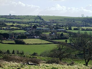
Priddy is a village in Somerset, England in the Mendip Hills, close to East Harptree and 4 miles (6 km) north-west of Wells. It is in the local government district of Mendip.

<span class="mw-page-title-main">Crook Peak to Shute Shelve Hill</span> Geological and biological Site of Special Scientific Interest in Somerset, England

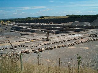
Crook Peak to Shute Shelve Hill is a 332.2 hectare (820.9 acre) geological and biological Site of Special Scientific Interest near the western end of the Mendip Hills, Somerset. The line of hills runs for approximately 5 kilometres (3.1 mi) from west to east and includes: Crook Peak, Compton Hill, Wavering Down, Cross Plain and Shute Shelve Hill. Most of the site is owned by the National Trust, which bought 725 acres (293 ha) in 1985, and much of it has been designated as common land. It was notified as an SSSI by Natural England in 1952.

<span class="mw-page-title-main">Maesbury Castle</span> Iron Age hillfort in Somerset, England

Maesbury Castle is an Iron Age hill fort within the parish of Croscombe on the Mendip Hills, just north of Shepton Mallet, Somerset, England. It has been listed as a Scheduled Ancient Monument.

<span class="mw-page-title-main">Rowberrow</span> Human settlement in England

Rowberrow is a small village and former civil parish, now in the parish of Shipham in the Somerset district, in the ceremonial county of Somerset, England. In 1931 the parish had a population of 56. On 1 April 1933 the parish was abolished and merged with Shipham.

<span class="mw-page-title-main">Quarries of the Mendip Hills</span> Quarries in the Mendip Hills, Somerset, UK

The Mendip Hills, (Mendips) in northern Somerset, are the most southerly Carboniferous Limestone uplands in Britain.

The Mendip Way is an 80-kilometre (50 mi) long-distance footpath across the Mendip Hills from Weston-super-Mare to Frome. It is divided into two sections.

<span class="mw-page-title-main">Starfish site</span> Night-time bombing decoy sites

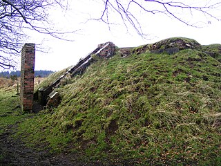
Starfish sites were large-scale night-time decoys created during the Blitz to simulate burning British cities. The aim was to divert German night bombers from their intended targets so they would drop their ordnance over the countryside. The sites were an extension of Colonel John Turner's decoy programme for airfields and factories. Following the bombing, and near destruction, of Coventry in November 1940, Turner was tasked with creating decoys for seven major cities.

<span class="mw-page-title-main">Pen Cerrig-calch</span> Mountain (701m) in Powys, Wales

Pen Cerrig-calch is a subsidiary summit of Waun Fach in the Black Mountains in the Brecon Beacons National Park in southern Powys, Wales. Its summit, at a height of 701 m (2,300 ft), is marked by a trig point. The peak sits high above the River Usk valley as it narrows above the small town of Crickhowell. The views from here are wide-ranging and extend as far as the Beacons themselves to the west. A ridge runs off to the northwest and the shoulder of Pen Gloch-y-pibwr then turns north to the secondary top of Pen Allt-mawr whose peak at 719m is also crowned by a trig point.

<span class="mw-page-title-main">Fan Gyhirych</span> Mountain (725m) in Powys, Wales

Fan Gyhirych is a mountain in the Fforest Fawr section of Brecon Beacons National Park in south Wales. It lies within the county of Breconshire, and administered as part of the unitary authority of Powys.

<span class="mw-page-title-main">Buckland Hill</span> Hill in Powys, Wales

Buckland Hill is a low hill in the Brecon Beacons National Park in the county of Powys in Wales. Sitting transversely across the Usk valley between the river and the village of Bwlch, it provides excellent panoramic views down the valley and across to the Black Mountains. The summit at 316m above sea level is marked by an OS trig point though this is now within a dense conifer plantation and so no longer affords any outward views. Buckland Hall sits at the foot of the hill's afforested northwestern side.

<span class="mw-page-title-main">Scheduled monuments in Mendip</span>

Mendip is a local government district of Somerset in England. The Mendip district covers a largely rural area of 285 square miles (738 km2) ranging from the Mendip Hills through on to the Somerset Levels. It has a population of approximately 110,000. The administrative centre of the district is Shepton Mallet but the largest town is Frome.

References

  1. "More Relative Hills of Britain" (PDF). Retrieved 27 May 2020.
  2. "Key Col for Beacon Batch" . Retrieved 27 May 2020.
  3. "Autumn newsletter 2007" (PDF). Mendip Hills AONB. Archived from the original (PDF) on 28 November 2007. Retrieved 25 September 2007.
  4. Haslett, Simon K. (2010). Somerset Landscapes: Geology and landforms. Usk: Blackbarn Books. pp. 26–27. ISBN   9781456416317.
  5. Kellaway, G. A.; Welch, F. B. A. (1948). Bristol and Gloucester District. British Regional Geology (Second ed.). London: HMSO for Natural Environment Research Council, Institute of Geological Sciences, Geographical Survey and Museum. pp. 7, 10–11, 16 & 34–38. ISBN   0-11-880064-7.
  6. Haslett, Simon K. (2010). Somerset Landscapes: Geology and landforms. Usk: Blackbarn Books. pp. 25–28. ISBN   9781456416317.
  7. "Black Down Geology Fact Sheet" (PDF). Discovering Black Down. Retrieved 14 December 2014.
  8. "Blackdown". British Geological Survey. Retrieved 14 December 2014.
  9. Atthill, Robin (1976). Mendip: A new study. Newton Abbot: David & Charles. p. 11. ISBN   0-7153-7297-1.
  10. Atthill, Robin (1976). Mendip: A new study. Newton Abbot: David & Charles. p. 42. ISBN   0-7153-7297-1.
  11. "Mendip Hills" (PDF). Character Area Appraisal. Natural England. pp. 122–128. Retrieved 9 April 2010.
  12. Adkins, Lesley and Roy (1992). A field Guide to Somerset Archeology. Stanbridge: Dovecote press. p. 24. ISBN   0-946159-94-7.
  13. Extract from record of Scheduled Monument
  14. 1 2 3 Brown, Donald (1999). Somerset v Hitler: Secret Operations in the Mendips 1939 - 1945. Newbury: Countryside Books. ISBN   1-85306-590-0. pages 165-177
  15. Davies, Les (March 2009). "Starfish and subterfuge". Mendip Times . Retrieved 24 February 2009.
  16. "Mendip Hills An Archaeological Survey of the Area of Outstanding Natural Beauty" (PDF). Somerset County Council Archeological Projects. Retrieved 16 January 2011.
  17. Historic England. "World War II bombing decoy complex, anti-aircraft obstructions and Beacon Batch round barrow cemetery on Black Down (1020995)". National Heritage List for England . Retrieved 5 April 2015.
  18. "World War II bombing decoy complex, anti-aircraft obstructions and Beacon Batch round barrow cemetery on Black Down, Priddy / Cheddar — Mendip". Heritage at Risk. English Heritage. Archived from the original on 27 July 2014. Retrieved 14 October 2013.
  19. "About". Discovering Black Down. Archived from the original on 14 December 2014. Retrieved 14 December 2014.

Commons-logo.svg Media related to Black Down, Somerset at Wikimedia Commons

51°18′42″N2°44′30″W / 51.31156°N 2.74170°W / 51.31156; -2.74170