
The Mendip Hills is a range of limestone hills to the south of Bristol and Bath in Somerset, England. Running from Weston-super-Mare and the Bristol Channel in the west to the Frome valley in the east, the hills overlook the Somerset Levels to the south and the Chew Valley and other tributaries of the Avon to the north. The hills give their name to the local government district of Mendip, which administers most of the area. The higher, western part of the hills, covering 198 km2 (76 sq mi) has been designated an Area of Outstanding Natural Beauty (AONB), which gives it a level of protection comparable to a national park.

The River Axe is a river in South West England. The river is formed by water entering swallets in the limestone and rises from the ground at Wookey Hole Caves in the Mendip Hills in Somerset, and runs through a V-shaped valley. The geology of the area is limestone and the water reaches Wookey Hole in a series of underground channels that have eroded through the soluble limestone. The river mouth is in Weston Bay on the Bristol Channel.

Chewton Mendip is a village and civil parish in the Mendip district of Somerset, England. It is situated 4 miles (6 km) north of Wells, 16 miles (26 km) south of Bath and Bristol on the A39 very close to the A37. The village is in a valley on the Mendip Hills and is the source of the River Chew. The parish includes the hamlets of Bathway and Green Ore.

Burrington Combe is a Carboniferous Limestone gorge near the village of Burrington, on the north side of the Mendip Hills Area of Outstanding Natural Beauty, in North Somerset, England.

Stock Hill is a Forestry Commission plantation on the Mendip Hills, Somerset, England.

Wurt Pit and Devil's Punchbowl is a 0.2 hectare geological Site of Special Scientific Interest between East Harptree and the Priddy Circles in the Mendip Hills, Somerset, notified in 1987.

Priddy is a village in Somerset, England in the Mendip Hills, close to East Harptree and 4 miles (6 km) north-west of Wells. It is in the local government district of Mendip.
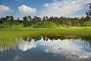
Brimble Pit and Cross Swallet Basins is a 154.3 hectare geological Site of Special Scientific Interest between Wookey Hole and Priddy in the Mendip Hills, Somerset, notified in 1987.

Chancellor's Farm is a 34.2-hectare biological Site of Special Scientific Interest just north of Priddy in the Mendip Hills, Somerset, notified in 1984.

Draycott Sleights is a 61.95 hectares biological Site of Special Scientific Interest at Draycott in the Mendip Hills, Somerset, England, notified in 1987. The name is pronounced locally as "Slates", presumably a variation on the Saxon word Slade meaning amongst other things hillside, rather than in the same manner as the Yorkshire place of the same spelling.
Priddy Caves is an Area: 67.6 hectare geological Site of Special Scientific Interest at Priddy in the Mendip Hills, Somerset, notified in 1965.
Priddy Pools is a 52.7-hectare (130-acre) geological Site of Special Scientific Interest at Priddy in the Mendip Hills, Somerset, notified in 1972.

The Cheddar Complex is a 441.3-hectare (1,090-acre) biological Site of Special Scientific Interest near Cheddar around the Cheddar Gorge and north east to Charterhouse in the Mendip Hills, Somerset, England, notified in 1952.

Charterhouse, also known as Charterhouse-on-Mendip, is a hamlet in the Mendip Hills Area of Outstanding Natural Beauty (AONB) in the English county of Somerset. The area between Charterhouse and Cheddar Gorge including Velvet Bottom and Ubley Warren is covered by the Cheddar Complex Site of Special Scientific Interest.

St Cuthbert's Swallet is the second longest, and most complex, cave on the Mendip Hills, in Somerset, England. It forms a major part of the Priddy Caves system and water entering this swallet re-emerges at Wookey Hole. St Cuthbert's Swallet is part of, and lies underneath, the Priddy Pools Site of Special Scientific Interest.

Stoke Lane Slocker is a cave near Stoke St Michael, in the Carboniferous Limestone of the Mendip Hills, in the English county of Somerset.
The Mendip Way is an 80-kilometre (50 mi) long-distance footpath across the Mendip Hills from Weston-super-Mare to Frome. It is divided into two sections.
Attborough Swallet is a cave in Chewton Mendip in Somerset, England.
Hunter's Hole is a cave in the Mendip Hills in Somerset, England. It is behind a pub, known as the Hunters Lodge Inn just outside Priddy where visitors can park. It is accessed via a permanent ladder, about 100m behind the pub in a small dip between some trees.

Priddy Nine Barrows Cemetery and Ashen Hill Barrow Cemetery are a collection of round barrows, dating from the Bronze Age, near Priddy in the English county of Somerset. They are designated as ancient monuments.
