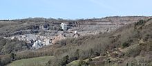
Cheddar is a large village and civil parish in the English county of Somerset. It is situated on the southern edge of the Mendip Hills, 9 miles (14 km) north-west of Wells, 11 miles (18 km) south-east of Weston-super-Mare and 18 miles (29 km) south-west of Bristol. The civil parish includes the hamlets of Nyland and Bradley Cross. The parish had a population of 5,755 in 2011 and an acreage of 8,592 acres (3,477 ha) as of 1961.
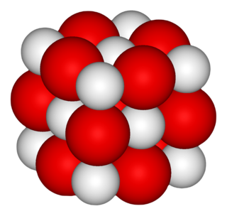
Calcium oxide, commonly known as quicklime or burnt lime, is a widely used chemical compound. It is a white, caustic, alkaline, crystalline solid at room temperature. The broadly used term lime connotes calcium-containing inorganic compounds, in which carbonates, oxides, and hydroxides of calcium, silicon, magnesium, aluminium, and iron predominate. By contrast, quicklime specifically applies to the single compound calcium oxide. Calcium oxide that survives processing without reacting in building products, such as cement, is called free lime.

The Mendip Hills is a range of limestone hills to the south of Bristol and Bath in Somerset, England. Running from Weston-super-Mare and the Bristol Channel in the west to the Frome valley in the east, the hills overlook the Somerset Levels to the south and the Chew Valley and other tributaries of the Avon to the north. The highest point, at 325 metres above sea level, is Beacon Batch which is the summit area atop Black Down. The hills gave their name to the former local government district of Mendip, which administered most of the local area until April 2023. The higher, western part of the hills, covering 198 km2 (76 sq mi) has been designated an Area of Outstanding Natural Beauty (AONB), which gives it a level of protection comparable to a national park.

Burrington Combe is a Carboniferous Limestone gorge near the village of Burrington, on the north side of the Mendip Hills Area of Outstanding Natural Beauty, in North Somerset, England.

Shipham is a village and civil parish in Somerset, England. It is on the western edge of the Mendip Hills near the A38, approximately 15 miles (24 km) south of Bristol. The parish includes the village of Rowberrow and the hamlet of Star. The parish population, according to the 2011 census, is 1,087.

Somerset is a rural county in the southwest of England, covering 4,171 square kilometres (1,610 sq mi). It is bounded on the north-west by the Bristol Channel, on the north by Bristol and Gloucestershire, on the north-east by Wiltshire, on the south-east by Dorset, and on the south west and west by Devon. It has broad central plains with several ranges of low hills. The landscape divides into four main geological sections from the Silurian through the Devonian and Carboniferous to the Permian which influence the landscape, together with water-related features.

Asham Wood is a 140.6-hectare (347-acre) biological Site of Special Scientific Interest east of Downhead and south of Leigh-on-Mendip in the Mendip Hills, Somerset, notified in 1963.
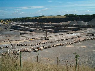
Whatley Quarry, grid reference ST731479 is a limestone quarry owned by Hanson plc, near the village of Whatley on the Mendip Hills, Somerset, England.

Gurney Slade quarry, grid reference ST626497 is a limestone quarry near Gurney Slade between Binegar and Holcombe, on the Mendip Hills, Somerset, England.
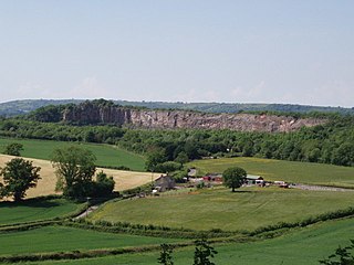
Callow Rock quarry is a limestone quarry located in Shipham Gorge between Cheddar and Shipham on the Mendip Hills, Somerset, England.
Dulcote Quarry is a disused limestone quarry at Dulcote, near Wells on the Mendip Hills, Somerset, England. The quarry measures around 600 metres (2,000 ft) from West to East and around 350 metres (1,150 ft) from North to South, with an area of 18 acres (7.3 ha), which is surrounded by 80 acres (32 ha) of woodland.
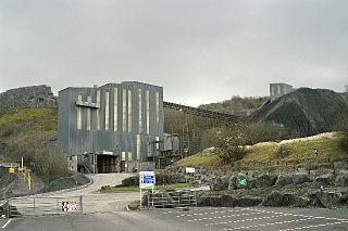
The Mendip Hills, (Mendips) in northern Somerset, are the most southerly Carboniferous Limestone uplands in Britain.

Torr Works quarry, grid reference ST695446 is a limestone quarry at East Cranmore, near Shepton Mallet on the Mendip Hills, Somerset, England. The quarry was formerly known as Merehead, a name which has been retained for its rail depot on the opposite side of the A361 road.

Penwyllt is a hamlet located in the upper Swansea Valley in Powys, Wales, lying within the Brecon Beacons National Park.
The Mendip Way is an 80-kilometre (50 mi) long-distance footpath across the Mendip Hills from Weston-super-Mare to Frome. It is divided into two sections.
Somerset is a county in the south west of England. It is a rural county and transport infrastructure has been significant in industrial development. There is some heavy industry particularly related to the defence technologies and the county has several centres for stone quarrying, although the coalfield is now closed.

Harpur Hill Quarry is a disused limestone quarry on Harpur Hill, Derbyshire, England. Limestone was extracted there from 1835 to 1952 for lime burning at lime kilns to produce quicklime. The quarry was used by the Royal Air Force as a chemical weapons storage depot during the Second World War, the largest such depot in the United Kingdom. Afterwards a number of captured German chemical munitions were disposed of at the site by burning, which was only partially successful. The RAF depot closed in 1960 and the site is now vacant.
Bishopswood Meadows is a nature reserve situated within the Blackdown Hills Area of Outstanding Natural Beauty in the county of Somerset, England. The reserve comprises five fields totalling 9.3 hectares ; all of the fields are on a gentle north-facing slope with the River Yarty at the base. The reserve, formerly part of Woodend Farm, was purchased by Somerset Wildlife Trust in 1991–92.

The Buxton lime industry has been important for the development of the town of Buxton in Derbyshire, England, and it has shaped the landscape around the town.

Underwood Quarry is a former quarry near Wells, Somerset on the southern edge of the Mendip Hills that produced Carboniferous Limestone. The rock was described as having very little faulting and a consistent nature, and as being ideal for road making and maintenance.