
The Mendip Hills is a range of limestone hills to the south of Bristol and Bath in Somerset, England. Running from Weston-super-Mare and the Bristol Channel in the west to the Frome valley in the east, the hills overlook the Somerset Levels to the south and the Chew Valley and other tributaries of the Avon to the north. The highest point, at 325 metres above sea level, is Beacon Batch which is the summit area atop Black Down. The hills gave their name to the former local government district of Mendip, which administered most of the local area until April 2023. The higher, western part of the hills, covering 198 km2 (76 sq mi) has been designated an Area of Outstanding Natural Beauty (AONB), which gives it a level of protection comparable to a national park.

The British Rail Class 59 is a fleet of Co-Co diesel-electric locomotives built between 1985 and 1995 by the Electro-Motive Division of General Motors for use in Great Britain. A total of 15 locomotives were built for three different operators.
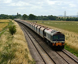
Mendip Rail Ltd is an independent freight operating railway company in Great Britain. It is a joint venture composed of the rail-operation divisions of Aggregate Industries and Hanson Aggregates.

St Cuthbert Out, sometimes Wells St Cuthbert Out, is a civil parish in the Mendip district of Somerset, England. It entirely surrounds the city and parish of Wells. According to the 2011 census it had a population of 3,749.

Somerset is a rural county in the southwest of England, covering 4,171 square kilometres (1,610 sq mi). It is bounded on the north-west by the Bristol Channel, on the north by Bristol and Gloucestershire, on the north-east by Wiltshire, on the south-east by Dorset, and on the south west and west by Devon. It has broad central plains with several ranges of low hills. The landscape divides into four main geological sections from the Silurian through the Devonian and Carboniferous to the Permian which influence the landscape, together with water-related features.
Foster Yeoman Limited, based near Frome, Somerset, England, was one of Europe's largest independent quarrying and asphalt companies. It was sold to Aggregate Industries in 2006.
Cloford Quarry is a 39.92-hectare (98.6-acre) geological Site of Special Scientific Interest to the south of the A361 approximately 350 metres (1,150 ft) north of the hamlet of Cloford and 1 kilometre (0.6 mi) west of Nunney on the Mendip Hills in Somerset. It was notified in 1994.
Moon's Hill Quarry is a 3.42 hectare geological Site of Special Scientific Interest at Stoke St Michael in Somerset, notified in 1996 and is a Geological Conservation Review site.

Cranmore is a village and civil parish east of Shepton Mallet, in the Mendip district of Somerset, England. The parish includes the hamlets of Waterlip, East Cranmore and Dean.
Downhead is a village and civil parish close to Leigh-on-Mendip and 5 miles (8 km) north east of Shepton Mallet, in the Mendip district of Somerset, England. The parish includes the medieval settlement of Tadhill.
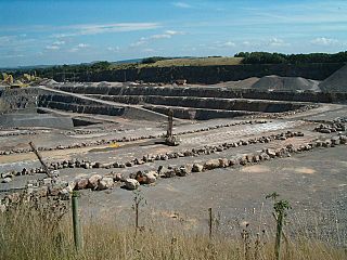
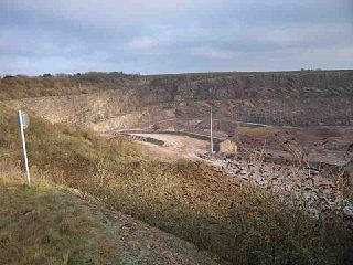
Whatley Quarry, grid reference ST731479 is a limestone quarry owned by Hanson plc, near the village of Whatley on the Mendip Hills, Somerset, England.
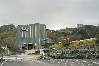
Halecombe is a limestone quarry near Leigh-on-Mendip on the Mendip Hills, Somerset, England.
Colemans Quarry, grid reference ST726452 is a limestone quarry at Holwell, near Nunney on the Mendip Hills, Somerset, England.

Gurney Slade quarry, grid reference ST626497 is a limestone quarry near Gurney Slade between Binegar and Holcombe, on the Mendip Hills, Somerset, England.
Callow Rock quarry is a limestone quarry located in Shipham Gorge between Cheddar and Shipham on the Mendip Hills, Somerset, England.
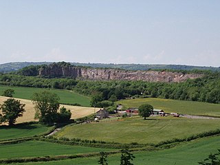
Dulcote Quarry is a disused limestone quarry at Dulcote, near Wells on the Mendip Hills, Somerset, England. The quarry measures around 600 metres (2,000 ft) from West to East and around 350 metres (1,150 ft) from North to South, with an area of 18 acres (7.3 ha), which is surrounded by 80 acres (32 ha) of woodland.
The Mendip Hills, (Mendips) in northern Somerset, are the most southerly Carboniferous Limestone uplands in Britain.
Somerset is a county in the south west of England. It is a rural county and transport infrastructure has been significant in industrial development. There is some heavy industry particularly related to the defence technologies and the county has several centres for stone quarrying, although the coalfield is now closed.

The county of Somerset is in South West England, bordered by the Bristol Channel and the counties of Bristol and Gloucestershire to the north, and Wiltshire to the east, Dorset to the south, and Devon to the west. The climate, influenced by its proximity to the Atlantic Ocean and the prevailing westerly winds, tends to be mild, damp and windy.
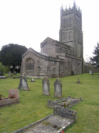
Leigh-on-Mendip or Leigh upon Mendip is a small village on the Mendip Hills in Somerset, England. It lies roughly equidistant from Frome, Radstock and Shepton Mallet at about 5 miles (8 km) from each town.


