Caves of the Mendip Hills

Last updated

Entrance to Swildon's Hole at Priddy, Somerset Swildon's Hole entrance 2.jpg
Entrance to Swildon's Hole at Priddy, Somerset

The caves of the Mendip Hills are formed by the particular geology of the Mendip Hills: large areas of limestone worn away by water makes it a national centre for caving. The hills conceal the largest underground river system in Britain. [1]

Contents

Geology

The hills consist of anticlines of Carboniferous Limestone lying over Devonian Old Red Sandstone, with the sandstone exposed on the summits. When a surface stream running off the sandstone reaches the limestone it sinks below ground through a "swallet", (also known locally as a "slocker"), continuing on its way down towards sea level by enlarging existing cracks in the rock to form caves, and reappearing at the base of the limestone outcrop. As the water changes route within the hill some caves (or parts of caves) are left dry. [2]

Stalagmites and stalactites in Gough's Cave Goughscave.jpg
Stalagmites and stalactites in Gough's Cave

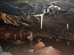
There is a characteristic type of Mendip cave, in which there is an initially steep descent, and then a more level stretch ending in a "sump" as the cave reaches and descends below the prevailing water table. The passages below the water table (which may be accessible by cave diving) often have a loop formation caused by the water flowing down a bedding plane and then rising up a fracture in the rock. [2] Few caves on the Mendip Hills are more than 150 metres (492 ft) deep or a few kilometres in length, [3] (with some notable exceptions, such as Swildon's Hole which is over 9 kilometres (6 mi) long [4] ), but a number are complex with several levels of passages which have been abandoned by the water, for example those around Cheddar. [5]

The catchment area of the Cheddar Yeo, which rises in Gough's Cave, measures 54 km2 (20.8 sq mi). Dye marking shows that some of the water travels underground for up to 10 miles (16 km), taking up to 14 days to reach Cheddar.

History

When Banwell Bone Cave was discovered in 1824, it was found to contain a great many animal bones which have been dated as about 80,000 years old. [6]

The earliest scientifically dated human cemetery in Britain was found at Aveline's Hole, in Burrington Combe. The human bone fragments it contained, from about 21 different individuals, are thought to be between roughly 10,200 and 10,400 years old. [7] [8]

Archaeological evidence including pottery, flints, hearths, coins, burials and metalwork from the Mesolithic, Neolithic, Bronze Age, Iron Age and Roman eras have been found in many of the caves. [9] [10] A number of Mendip caves were found by miners, for example the Banwell Caves which were opened by ochre miners in 1757. [6]

Many caves in the Mendip area were photographed by caver Harry Savory early in the 20th century using huge cameras, glass plates and flash powder. His work has been described as "...of a quality to shame virtually all modern cave photographers". The 1990 book A Man Deep in Mendip: The Caving Diaries of Harry Savory, 1910-1921 provides a diary made by Harry Savory, explained and extended by his son John. [11]

A number of important cave excavations and explorations were undertaken, from the 1920s onwards, by pioneer caver Herbert E. Balch. The caves are recorded in the Mendip Cave Registry and Archive. [12]

Access

The caves which are easily accessible to the public are at Cheddar Gorge and Wookey Hole, but the vast majority of the caves require specialist equipment and knowledge. Many of the caves are gated and operate leader systems in an attempt to reduce the damage caused when the caves are visited. [13] Local caving groups organise trips and continue to discover new caverns. Some estimates put the number of cavers active on the Mendip Hills over a busy weekend at more than 500. [14]

Cave diving

Attempts made in the Mendip Hills to traverse from one cave to another through the underground rivers led to the development of cave diving; the first cave dive attempt in Britain took place at Swildon's Hole in 1934. The first successful cave dive in Britain was achieved the following year at Wookey Hole Caves, where the last sump is currently the deepest in Britain at 90 m (300 ft). [15]

Sites of special scientific interest

The cave complexes at St. Dunstan's Well Catchment, Thrupe Lane Swallet, Lamb Leer and Priddy Caves have been identified as geological Site of Special Scientific Interest. There are also caves within the Cheddar Complex SSSI.

List of caves

A selection of the better known caves are listed below

NameLocationMapLength (km)Depth (m)Notes
Attborough Swallet Chewton Mendip ST56105181 0.22 [14] 44 [14]
Aveline's Hole Burrington Combe ST47615867 0.06716Site of early cemetery & cave markings
Axbridge Ochre Mine Axbridge ST429552 0.13233
Banwell Caves Banwell ST38225881 0.09721 geological Site of Special Scientific Interest
Banwell Ochre Caves Banwell ST40605904 geological Site of Special Scientific Interest
Bos Swallet Burrington Combe ST47095837 0.07637
Bath Swallet Burrington Combe ST47255845 0.078 [16] 42 [16]
Charterhouse Cave Charterhouse ST47755620 4.868 [17] 205 [17] Close, but not connected, to GB Cave. Deepest cave on the Mendip Hills.
Compton Martin Ochre Mine Compton Martin ST543566 0.421 geological Site of Special Scientific Interest
Cox's Cave Cheddar ST46465390 0.1 [14] 18 [14] Open to the general public as a show cave
Drunkard's Hole Burrington Combe ST47145839 0.127 [18] 48 [18]
Eastwater Cavern Priddy ST53885062 2.8 [14] 160 [14] One of the Priddy Caves
East Twin Swallet Burrington Combe ST47955814 0.274 [19] 38 [19]
Fairy Cave Quarry
*Balch Cave
*Conning Tower Cave
*Fairy Cave
*Fernhill Cave
*Hillier's Cave
*Hillwithy Cave
*Shatter Cave
*W/L Cave
*Withyhill Cave
Stoke St Michael ST65654775 1.17 [20] <60 [20] Many highly decorated.
GB Cave Charterhouse ST47595623 1.95 [20] 134 [20] Part of the Cheddar Complex SSSI.
Goatchurch Cavern Burrington Combe ST47585823 0.75 [14] 55 [14] Very popular with novice cavers
Gough's Cave Cheddar ST46705391 2.135 [20] 90 [20] Open to the general public as a show cave
Hunter's Hole Priddy ST54925005 0.275 [14] 58 [14] One of the Priddy Caves
Lamb Leer East Harptree ST54325505 0.6467 geological Site of Special Scientific Interest
Longwood Swallet Charterhouse ST48615571 1.65175Part of the Cheddar Complex SSSI.
Manor Farm Swallet Charterhouse ST49825566 1.06 [20] 156 [20]
Picken's Hole Compton Bishop ST3968055004
Pierre's Pot Burrington Combe ST47635837 0.465 [14] 33 [14]
Read's Cavern Burrington Combe ST46825844 1.224 [14] 62 [14]
Reservoir Hole Cheddar ST47465447 Length/depth to be confirmed following the recent discovery of what is believed to be the largest chamber under the Mendip Hills.
Rhino Rift Charterhouse ST48475557 0.25147Part of the Cheddar Complex SSSI.
Rod's Pot Burrington ST47215844 0.18845In September 2007, digging established a link through to nearby Bath Swallet
Sidcot Swallet Burrington ST47545828 0.228
St Cuthbert's Swallet Priddy ST54305050 6.7 [14] 145 [14] One of the Priddy Caves. Most complex cave on Mendip.
Stoke Lane Slocker Stoke St Michael ST66874745 2.18 [20] <60 [20]
Swildon's Hole Priddy ST53125131 9.15 [14] 167 [14] One of the Priddy Caves. Longest cave on Mendip.
Thrupe Lane Swallet Shepton Mallet ST60384580 1.147 [20] 120 [20] geological Site of Special Scientific Interest
Tyning's Barrow Swallet Cheddar ST47135638 1.29 [20] 132 [20]
Upper Flood Swallet Charterhouse ST50575576 4.720 [20] 136 [20]
Wigmore Swallet Priddy ST55715256 1.0 [14] 110 [14] One of the Priddy Caves.
Withybrook Slocker Stoke St Michael ST65534715 0.2326Upstream part of caves in Fairy Cave Quarry
Wookey Hole Caves Wookey Hole ST53184802 3.66 [20] 182 [20] Open to the general public as a show cave

Related Research Articles

Wookey Hole Caves Series of limestone caverns in Somerset county, England

Wookey Hole Caves are a series of limestone caverns, a show cave and tourist attraction in the village of Wookey Hole on the southern edge of the Mendip Hills near Wells in Somerset, England. The River Axe flows through the cave. It is a Site of Special Scientific Interest (SSSI) for both biological and geological reasons. Wookey Hole cave is a "solutional cave", one that is formed by a process of weathering in which the natural acid in groundwater dissolves the rocks. Some water originates as rain that flows into streams on impervious rocks on the plateau before sinking at the limestone boundary into cave systems such as Swildon's Hole, Eastwater Cavern and St Cuthbert's Swallet; the rest is rain that percolates directly through the limestone. The temperature in the caves is a constant 11 °C (52 °F).

Mendip Hills Range of limestone hills to the south of Bristol and Bath in Somerset, England

The Mendip Hills is a range of limestone hills to the south of Bristol and Bath in Somerset, England. Running east to west between Weston-super-Mare and Frome, the hills overlook the Somerset Levels to the south and the Chew Valley and other tributaries of the Avon to the north. The hills give their name to the local government district of Mendip, which administers most of the area. The higher, western part of the hills, covering 198 km2 (76 sq mi) has been designated an Area of Outstanding Natural Beauty (AONB), which gives it a level of protection comparable to a national park.

Swildons Hole

Swildon's Hole is an extensive cave in Priddy, Somerset. At 9,144 metres (30,000 ft) in length, it is the longest cave on the Mendip Hills. It has been found to be connected to Priddy Green Sink and forms part of the Priddy Caves Site of Special Scientific Interest (SSSI).

River Axe (Bristol Channel)

The River Axe is a river in South West England. The river is formed by water entering swallets in the limestone and rises from the ground at Wookey Hole Caves in the Mendip Hills in Somerset, and runs through a V-shaped valley. The geology of the area is limestone and the water reaches Wookey Hole in a series of underground channels that have eroded through the soluble limestone. The river mouth is in Weston Bay on the Bristol Channel.

Burrington Combe

Burrington Combe is a Carboniferous Limestone gorge near the village of Burrington, on the north side of the Mendip Hills Area of Outstanding Natural Beauty, in North Somerset, England.

Cheddar Complex

The Cheddar Complex is a 441.3 hectare biological Site of Special Scientific Interest near Cheddar around the Cheddar Gorge and north east to Charterhouse in the Mendip Hills, Somerset, England, notified in 1952.

Thrupe Lane Swallet is a 0.5 hectares geological Site of Special Scientific Interest in Somerset, notified in 1992. It is also a Geological Conservation Review site.

Avelines Hole Cave and archaeological site in the United Kingdom

Aveline's Hole is a cave at Burrington Combe in the limestone of the Mendip Hills, in Somerset, England.

Eastwater Cavern

Eastwater Cavern is a cave near Priddy in the limestone of the Mendip Hills, in Somerset, England. It is also known as Eastwater Swallet. It was first excavated in April 1902 by a team led by Herbert E. Balch composed of paid labourers and volunteers from the Wells Natural History Society. Progress was initially slow, but by February 1903 Balch and Willcox had discovered substantial passage, following the streamway down to the bottom of the cave. Dolphin Pot was dug in 1940 by the Wessex Cave Club, with Primrose Pot following in 1950. West End series was the most recent significant discovery, in 1983.

GB Cave

GB Cave is a cave between Charterhouse and Shipham in the limestone of the Mendip Hills, in Somerset, England.

Goatchurch Cavern

Goatchurch Cavern is a cave on the edge of Burrington Combe in the limestone of the Mendip Hills, in Somerset, England.

St Cuthberts Swallet Cave in the Mendip Hills, Somerset, England

St Cuthbert's Swallet is the second longest, and most complex, cave on the Mendip Hills, in Somerset, England. It forms a major part of the Priddy Caves system and water entering this swallet re-emerges at Wookey Hole. St Cuthbert's Swallet is part of, and lies underneath, the Priddy Pools Site of Special Scientific Interest.

Stoke Lane Slocker

Stoke Lane Slocker is a cave near Stoke St Michael, in the Carboniferous Limestone of the Mendip Hills, in the English county of Somerset.

Upper Flood Swallet

Upper Flood Swallet which was originally known as Blackmoor Flood Swallet, is an exceptionally well-decorated cave near Charterhouse, in the carboniferous limestone of the Mendip Hills, in Somerset, England. The cave is part of the Cheddar Complex SSSI.

Sidcot Swallet

Sidcot Swallet is a cave near Burrington Combe, in the Carboniferous Limestone of the Mendip Hills, in Somerset, England.

Rods Pot

Rod's Pot is a limestone cave above Burrington Combe in the Mendip Hills, in Somerset, England.

Attborough Swallet is a cave in Chewton Mendip in Somerset, England.

Pierres Pot


Pierre's Pot is a karst cave in Burrington Combe on the Mendip Hills in Somerset, England.

Hunter's Hole is a cave in the Mendip Hills in Somerset, England. It is behind a pub, known as the Hunters Lodge Inn just outside Priddy where visitors can park. It is accessed via a permanent ladder, about 100m behind the pub in a small dip between some trees.

William Talbot Aveline (1822–1903) was a British geologist and archaeologist.

References

  1. "Fact Sheet 8: Rivers" (PDF). Cheddar caves. Archived from the original (PDF) on 22 June 2006. Retrieved 27 January 2007.
  2. 1 2 "Mendip Caves: How caves form". British Geological Survey. 2008. Retrieved 6 February 2009.
  3. "Mendip Caves: Introduction". British Geological Survey. 2008. Retrieved 6 February 2009.
  4. "Mendip Caves: Wookey Hole Catchment". British Geological Survey. 2008. Retrieved 6 February 2009.
  5. "Mendip Caves: Cheddar Catchment". British Geological Survey. 2008. Retrieved 6 February 2009.
  6. 1 2 "Mendip Caves: Western Mendip". British Geological Survey. 2008. Retrieved 6 February 2009.
  7. "Earliest British cemetery dated". BBC News. 23 September 2003. Retrieved 27 January 2007.
  8. "Aveline's Hole - An Early Mesolithic Cemetery Site in the Mendips". Rick Schulting. Archived from the original on 12 July 2006. Retrieved 27 January 2007.
  9. "Mendip Hills: An Archaeological Survey of the Area of Outstanding Natural Beauty" (PDF). Mendip Hills AONB. Retrieved 27 January 2007.
  10. "Mendip Caves: The Burrington area". British Geological Survey. 2008. Retrieved 6 February 2009.
  11. Savory, H. and Savory, J. (1990) A Man Deep in Mendip: The Caving Diaries of Harry Savory, 1910-1921, Southern Illinois University Press, ISBN   978-0-8093-1623-6
  12. "History". Mendip Cave Registry and Archives. Retrieved 29 December 2015.
  13. "Mendip". Protect Our Caves. Retrieved 8 October 2010.
  14. 1 2 3 4 5 6 7 8 9 10 11 12 13 14 15 16 17 18 19 20 21 Irwin & Knibbs, Mendip Underground: A Cavers Guide
  15. Hanwell, Jim; Price, Duncan; Witcombe, Richard (2010). Wookey Hole - 75 years of cave diving and exploration. Wells: Cave Diving Group. pp. 338–340. ISBN   978-0-901031-07-5.
  16. 1 2 "Bath Swallet". Mendip Cave Registry & Archive. Retrieved 11 May 2019.
  17. 1 2 "Charterhouse Cave". UK Caves database. Retrieved 5 September 2009.
  18. 1 2 D.J. Irwin & A.R. Jarret. Mendip underground : a caver's guide. Rev. ed. ISBN   9780905903125.
  19. 1 2 "East Twin Swallet". Mendip Cave Registry & Archive. Retrieved 11 May 2009.
  20. 1 2 3 4 5 6 7 8 9 10 11 12 13 14 15 16 17 18 "Mendip". UK and Ireland Cave Lengths and Depths. Retrieved 15 January 2007.

Bibliography