
Wookey Hole Caves are a series of limestone caverns, a show cave and tourist attraction in the village of Wookey Hole on the southern edge of the Mendip Hills near Wells in Somerset, England. The River Axe flows through the cave. It is a Site of Special Scientific Interest (SSSI) for both biological and geological reasons. Wookey Hole cave is a "solutional cave", one that is formed by a process of weathering in which the natural acid in groundwater dissolves the rocks. Some water originates as rain that flows into streams on impervious rocks on the plateau before sinking at the limestone boundary into cave systems such as Swildon's Hole, Eastwater Cavern and St Cuthbert's Swallet; the rest is rain that percolates directly through the limestone. The temperature in the caves is a constant 11 °C (52 °F).

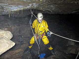
Cave-diving is underwater diving in water-filled caves. It may be done as an extreme sport, a way of exploring flooded caves for scientific investigation, or for the search for and recovery of divers or, as in the 2018 Thai cave rescue, other cave users. The equipment used varies depending on the circumstances, and ranges from breath hold to surface supplied, but almost all cave-diving is done using scuba equipment, often in specialised configurations with redundancies such as sidemount or backmounted twinset. Recreational cave-diving is generally considered to be a type of technical diving due to the lack of a free surface during large parts of the dive, and often involves planned decompression stops. A distinction is made by recreational diver training agencies between cave-diving and cavern-diving, where cavern diving is deemed to be diving in those parts of a cave where the exit to open water can be seen by natural light. An arbitrary distance limit to the open water surface may also be specified.
Krubera Cave is the second-deepest-known cave on Earth, after the Veryovkina Cave. It is located in the Arabika Massif of the Gagra Range of the Western Caucasus, in the Gagra District of Abkhazia, a partly recognised state, previously part of Soviet Georgia.

Swildon's Hole is an extensive cave in Priddy, Somerset. At 9,144 metres (30,000 ft) in length, it is the longest cave on the Mendip Hills. It has been found to be connected to Priddy Green Sink and forms part of the Priddy Caves Site of Special Scientific Interest (SSSI).

The Cave Diving Group (CDG) is a United Kingdom-based diver training organisation specialising in cave diving.

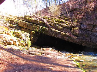
A sump is a low space that collects often undesirable liquids such as water or chemicals. A sump can also be an infiltration basin used to manage surface runoff water and recharge underground aquifers. Sump can also refer to an area in a cave where an underground flow of water exits the cave into the earth.

The Marble Arch Caves are a series of natural limestone caves located near the village of Florencecourt in County Fermanagh, Northern Ireland. The caves are named after the nearby Marble Arch, a natural limestone arch at the upstream end of Cladagh Glen under which the Cladagh River flows. The caves are formed from three rivers draining off the northern slopes of Cuilcagh mountain, which combine underground to form the Cladagh. On the surface, the river emerges from the largest karst resurgence in Ireland, and one of the largest in the United Kingdom. At 11.5 kilometres (7.1 mi) the Marble Arch Caves form the longest known cave system in Northern Ireland, and the karst is considered to be among the finest in the British Isles.

The Dersios sinkhole is a sinkhole in Arcadia, Greece.
Tytoona Cave is located approximately 1-mile (1.6 km) from Arch Springs, Pennsylvania in Sinking Valley, near Tyrone and Altoona, in the United States.
Shannon Cave is an active stream passage cave which straddles the border of County Fermanagh, Northern Ireland and County Cavan in the Republic of Ireland.
The Caves of the Tullybrack and Belmore hills are a collection of caves in southwest County Fermanagh, Northern Ireland. The region is also described as the West Fermanagh Scarplands by environmental agencies and shares many similar karst features with the nearby Marble Arch Caves Global Geopark.

The Cheddar Yeo is a small river in Somerset, England. Beneath the limestone of the Mendip Hills it forms the largest underground river system in Britain. After emerging into Cheddar Gorge it flows through the village of Cheddar, where it has been used in the past to power mills. From the Middle Ages until the 19th century the river had ports for seagoing vessels but is no longer navigable. Some of the water, which is of good quality, is diverted into Cheddar Reservoir to provide drinking water for Bristol.
Aquamole Pot is a limestone cave in West Kingsdale, North Yorkshire, England. It was originally discovered by cave divers who negotiated 168 metres (551 ft) of sump passage from Rowten Pot in 1974, to enter a high aven above the river passage. All subsequent major explorations were undertaken from below before an entrance was opened up from the surface. It is part of a 27-kilometre (17 mi) long cave system that drains both flanks of Kingsdale.
The Nidderdale Caves are a series of caves in Upper Nidderdale in North Yorkshire, England. There are two cave systems and most of the caves are in some way linked with one or the other. The smaller system is the Eglin cave system in the valley of How Stean Beck, a tributary of the River Nidd, associated with How Stean Gorge. The larger system is the Goyden cave system under the valley of the River Nidd, which flows east from Scar House Reservoir, then south, and shortly after disappears underground down several sinkholes to reappear at the rising just beyond the village of Lofthouse. Cavers can access several sections of this system via the different entrances.

Short Drop Cave and Gavel Pot are different entrances into the same cave system on Leck Fell, in Lancashire, England. The main top entrance, Short Drop Cave, is a small hole in a fenced-off shakehole near the main stream sink. Gavel Pot, a window into the system, is a large fenced shakehole some 40-metre (130 ft) deep requiring tackle to descend. There are two other smaller entrances into Short Drop Cave. At its base the system links via a sump with Lost Johns' Cave, and is part of the Three Counties System, an 87 kilometres (54 mi) cave system which spans the borders of Cumbria, Lancashire, and North Yorkshire.
There are a number of terms that are used in connection with caves, caving and speleology. The following is an incomplete list.

The Bournillon cave is located in the commune of Châtelus in the Isère Department of France, in the Vercors Massif. Its entrance is 105 metres (344 ft) high, and 60 metres (200 ft) wide, and is the largest in Europe. It is one of the main karst springs of Vercors, with a maximum flow rate of 80 cubic metres (2,800 cu ft) per second, which feeds a hydroelectric plant.
Cave diving is underwater diving in water-filled caves. The equipment used varies depending on the circumstances, and ranges from breath hold to surface supplied, but almost all cave diving is done using scuba equipment, often in specialised configurations with redundancies such as sidemount or backmounted twinset. Recreational cave diving is generally considered to be a type of technical diving due to the lack of a free surface during large parts of the dive, and often involves planned decompression stops. A distinction is made by recreational diver training agencies between cave diving and cavern diving, where cavern diving is deemed to be diving in those parts of a cave where the exit to open water can be seen by natural light. An arbitrary distance limit to the open water surface may also be specified. Despite the risks, water-filled caves attract scuba divers, cavers, and speleologists due to their often unexplored nature, and present divers with a technical diving challenge.

The Gournier Cave is located near Choranche in the Vercors Massif in south-eastern France. The entrance is at an altitude of 572 m (1,877 ft) at the base of a cliff on the Presles plateau. It is one of the exsurgences of the Coulmes massif, and the cave is considered by many speleologists to be the most beautiful underground river in the Alps.
