Phreatic zone

Last updated
Cross-section of a hillslope depicting the vadose zone, capillary fringe, water table, and the phreatic or saturated zone. (Source: United States Geological Survey.) Vadose zone.gif
Cross-section of a hillslope depicting the vadose zone, capillary fringe, water table, and the phreatic or saturated zone. (Source: United States Geological Survey.)
Cross section showing the water table varying with surface topography as well as a perched water table Water table.svg
Cross section showing the water table varying with surface topography as well as a perched water table

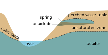
The phreatic zone, saturated zone, or zone of saturation, is the part of an aquifer, below the water table, in which relatively all pores and fractures are saturated with water. The part above the water table is the vadose zone (also called unsaturated zone).

The phreatic zone size, color, and depth may fluctuate with changes of season, and during wet and dry periods. [1] [2] Depending on the characteristics of soil particles, their packing and porosity, the boundary of a saturated zone can be stable or instable, exhibiting fingering patterns known as Saffman–Taylor instability. Predicting the onset of stable vs. unstable drainage fronts is of some importance in modelling phreatic zone boundaries. [3]

See also

Related Research Articles

<span class="mw-page-title-main">Aquifer</span> Underground layer of water-bearing permeable rock

An aquifer is an underground layer of water-bearing material, consisting of permeable or fractured rock, or of unconsolidated materials. Aquifers vary greatly in their characteristics. The study of water flow in aquifers and the characterization of aquifers is called hydrogeology. Related terms include aquitard, which is a bed of low permeability along an aquifer, and aquiclude, which is a solid, impermeable area underlying or overlying an aquifer, the pressure of which could lead to the formation of a confined aquifer. The classification of aquifers is as follows: Saturated versus unsaturated; aquifers versus aquitards; confined versus unconfined; isotropic versus anisotropic; porous, karst, or fractured; transboundary aquifer.

<span class="mw-page-title-main">Water table</span> Top of a saturated aquifer, or where the water pressure head is equal to the atmospheric pressure

The water table is the upper surface of the zone of saturation. The zone of saturation is where the pores and fractures of the ground are saturated with groundwater, which may be fresh, saline, or brackish, depending on the locality. It can also be simply explained as the depth below which the ground is saturated.

Phreatic is a term used in hydrology to refer to aquifers, in speleology to refer to cave passages, and in volcanology to refer to a type of volcanic eruption.

Soil moisture is the water content of the soil. It can be expressed in terms of volume or weight. Soil moisture measurement can be based on in situ probes or remote sensing methods.

<span class="mw-page-title-main">Vadose zone</span> Unsaturated aquifer above the water table

The vadose zone, also termed the unsaturated zone, is the part of Earth between the land surface and the top of the phreatic zone, the position at which the groundwater is at atmospheric pressure. Hence, the vadose zone extends from the top of the ground surface to the water table.

<span class="mw-page-title-main">Water content</span> Quantity of water contained in a material

Water content or moisture content is the quantity of water contained in a material, such as soil, rock, ceramics, crops, or wood. Water content is used in a wide range of scientific and technical areas, and is expressed as a ratio, which can range from 0 to the value of the materials' porosity at saturation. It can be given on a volumetric or mass (gravimetric) basis.

<span class="mw-page-title-main">Capillary fringe</span> Subsurface layer in which groundwater seeps up from a water table by capillary action

The capillary fringe is the subsurface layer in which groundwater seeps up from a water table by capillary action to fill pores. Pores at the base of the capillary fringe are filled with water due to tension saturation. This saturated portion of the capillary fringe is less than the total capillary rise because of the presence of a mix in pore size. If the pore size is small and relatively uniform, it is possible that soils can be completely saturated with water for several feet above the water table. Alternately, when the pore size is large, the saturated portion will extend only a few inches above the water table. Capillary action supports a vadose zone above the saturated base, within which water content decreases with distance above the water table. In soils with a wide range in pore size, the unsaturated zone can be several times thicker than the saturated zone.

<span class="mw-page-title-main">Infiltration (hydrology)</span> Process by which water on the ground surface enters the soil

Infiltration is the process by which water on the ground surface enters the soil. It is commonly used in both hydrology and soil sciences. The infiltration capacity is defined as the maximum rate of infiltration. It is most often measured in meters per day but can also be measured in other units of distance over time if necessary. The infiltration capacity decreases as the soil moisture content of soils surface layers increases. If the precipitation rate exceeds the infiltration rate, runoff will usually occur unless there is some physical barrier.

Pore water pressure refers to the pressure of groundwater held within a soil or rock, in gaps between particles (pores). Pore water pressures below the phreatic level of the groundwater are measured with piezometers. The vertical pore water pressure distribution in aquifers can generally be assumed to be close to hydrostatic.

The Richards equation represents the movement of water in unsaturated soils, and is attributed to Lorenzo A. Richards who published the equation in 1931. It is a quasilinear partial differential equation; its analytical solution is often limited to specific initial and boundary conditions. Proof of the existence and uniqueness of solution was given only in 1983 by Alt and Luckhaus. The equation is based on Darcy-Buckingham law representing flow in porous media under variably saturated conditions, which is stated as

Subsurface flow, in hydrology, is the flow of water beneath earth's surface as part of the water cycle.

Groundwater models are computer models of groundwater flow systems, and are used by hydrologists and hydrogeologists. Groundwater models are used to simulate and predict aquifer conditions.

<span class="mw-page-title-main">Soil salinity control</span> Controlling the problem of soil salinity

Soil salinity control refers to controlling the process and progress of soil salinity to prevent soil degradation by salination and reclamation of already salty (saline) soils. Soil reclamation is also called soil improvement, rehabilitation, remediation, recuperation, or amelioration.

<span class="mw-page-title-main">SahysMod</span>

SahysMod is a computer program for the prediction of the salinity of soil moisture, groundwater and drainage water, the depth of the watertable, and the drain discharge in irrigated agricultural lands, using different hydrogeologic and aquifer conditions, varying water management options, including the use of ground water for irrigation, and several crop rotation schedules, whereby the spatial variations are accounted for through a network of polygons.

<span class="mw-page-title-main">SaltMod</span> Salinity modelling software

SaltMod is computer program for the prediction of the salinity of soil moisture, groundwater and drainage water, the depth of the watertable, and the drain discharge (hydrology) in irrigated agricultural lands, using different (geo)hydrologic conditions, varying water management options, including the use of ground water for irrigation, and several cropping rotation schedules. The water management options include irrigation, drainage, and the use of subsurface drainage water from pipe drains, ditches or wells for irrigation.

<span class="mw-page-title-main">Agricultural hydrology</span>

Agricultural hydrology is the study of water balance components intervening in agricultural water management, especially in irrigation and drainage.

DPHM-RS is a semi-distributed hydrologic model developed at University of Alberta, Canada.

<span class="mw-page-title-main">Epiphreatic zone</span> Zone between the saturated and unsaturated zones

In a cave system, the epiphreatic zone or floodwater zone is the zone between the vadose (unsaturated) zone above and phreatic (saturated) zone below. It is regularly flooded and has a significant porosity. It has a great potential for cave formation.

<span class="mw-page-title-main">Non-aqueous phase liquid</span> Liquid solution contaminants that do not dissolve in or easily mix with water

Non-aqueous phase liquids, or NAPLs, are organic liquid contaminants characterized by their relative immiscibility with water. Common examples of NAPLs are petroleum products, coal tars, chlorinated solvents, and pesticides. Strategies employed for their removal from the subsurface environment have expanded since the late-20th century.

<span class="mw-page-title-main">Finite water-content vadose zone flow method</span>

The finite water-content vadose zone flux method represents a one-dimensional alternative to the numerical solution of Richards' equation for simulating the movement of water in unsaturated soils. The finite water-content method solves the advection-like term of the Soil Moisture Velocity Equation, which is an ordinary differential equation alternative to the Richards partial differential equation. The Richards equation is difficult to approximate in general because it does not have a closed-form analytical solution except in a few cases. The finite water-content method, is perhaps the first generic replacement for the numerical solution of the Richards' equation. The finite water-content solution has several advantages over the Richards equation solution. First, as an ordinary differential equation it is explicit, guaranteed to converge and computationally inexpensive to solve. Second, using a finite volume solution methodology it is guaranteed to conserve mass. The finite water content method readily simulates sharp wetting fronts, something that the Richards solution struggles with. The main limiting assumption required to use the finite water-content method is that the soil be homogeneous in layers.

References

  1. "Phreatic Zone". TheFreeDictionary.com. Retrieved 7 June 2012.
  2. "Phreatic Zone". Encyclopædia Britannica. Retrieved 7 June 2012.
  3. Dynamics of Drainage and Viscous Fingering in Transport in Porous Media
    Note that zones "behind" the drainage front are areas on the 'dry' (low-viscosity) (typically above / beyond the 'wet' zone).