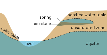
Vadose zone

Last updated
Cross-section of a hillslope depicting the vadose zone, capillary fringe, water table, and phreatic or saturated zone. (Source: United States Geological Survey.) Vadose zone.gif
Cross-section of a hillslope depicting the vadose zone, capillary fringe, water table, and phreatic or saturated zone. (Source: United States Geological Survey.)
Cross section showing the water table varying with surface topography as well as a perched water table Water table.svg
Cross section showing the water table varying with surface topography as well as a perched water table

The vadose zone, also termed the unsaturated zone, is the part of Earth between the land surface and the top of the phreatic zone, the position at which the groundwater (the water in the soil's pores) is at atmospheric pressure ("vadose" is from the Latin word for "shallow"). Hence, the vadose zone extends from the top of the ground surface to the water table.

Contents

Water in the vadose zone has a pressure head less than atmospheric pressure, and is retained by a combination of adhesion (funiculary groundwater), and capillary action (capillary groundwater). If the vadose zone envelops soil, the water contained therein is termed soil moisture. In fine grained soils, capillary action can cause the pores of the soil to be fully saturated above the water table at a pressure less than atmospheric. The vadose zone does not include the area that is still saturated above the water table, often referred to as the capillary fringe. [1]

Movement of water within the vadose zone is studied within soil physics and hydrology, particularly hydrogeology, and is of importance to agriculture, contaminant transport, and flood control. The Richards equation is often used to mathematically describe the flow of water, which is based partially on Darcy's law. Groundwater recharge, which is an important process that refills aquifers, generally occurs through the vadose zone from precipitation.

In hydrology

The sharp contact between the vadose zone (brown oxidized mudstone) and the underlying phreatic zone (grey unoxidized mudstone) exposed at a construction site. Vadose Zone.jpg
The sharp contact between the vadose zone (brown oxidized mudstone) and the underlying phreatic zone (grey unoxidized mudstone) exposed at a construction site.

The vadose zone is the undersaturated portion of the subsurface that lies above the groundwater table. The soil and rock in the vadose zone are not fully saturated with water; that is, the pores within them contain air as well as water. The portion of the vadose zone that is inhabited by soil microorganism, fungi and plant roots may sometimes be called the soil carbon sponge.

In some places, the vadose zone is absent, as is common where there are lakes and marshes, and in some places, it is hundreds of meters thick, as is common in arid regions. [2]

Unlike the aquifers of the underlying water-saturated phreatic zone, the vadose zone is not a source of readily available water for human consumption. It is of great importance in providing water and nutrients that are vital to the soil carbon sponge and the biosphere. It is intensively used for the cultivation of plants, construction of buildings, and disposal of waste. [2]

The vadose zone is often the main factor controlling water movement from the land surface to the aquifer. Thus, it strongly affects the rate of aquifer recharge and is critical for the use and management of groundwater. Flow rates and chemical reactions in the vadose zone also control whether, where, and how fast contaminants enter groundwater supplies. Understanding of vadose-zone processes is therefore crucial in determining the amount and quality of groundwater that is available for human use. [2]

In speleology

An example of a vadose cave passage in Mammoth Cave, Kentucky Mammoth cave canyon.jpg
An example of a vadose cave passage in Mammoth Cave, Kentucky

In speleology, cave passages formed in the vadose zone tend to be canyon-like in shape, as the water dissolves bedrock on the floor of the passage. [3] Passages created in completely water-filled conditions are called phreatic passages and tend to be circular in cross-section. [4]

See also

Related Research Articles

<span class="mw-page-title-main">Aquifer</span> Underground layer of water-bearing permeable rock

An aquifer is an underground layer of water-bearing, permeable rock, rock fractures, or unconsolidated materials. Groundwater from aquifers can be extracted using a water well. Water from aquifers can be sustainably harvested through the use of qanats. Aquifers vary greatly in their characteristics. The study of water flow in aquifers and the characterization of aquifers is called hydrogeology. Related terms include aquitard, which is a bed of low permeability along an aquifer, and aquiclude, which is a solid, impermeable area underlying or overlying an aquifer, the pressure of which could create a confined aquifer. The classification of aquifers is as follows: Saturated versus unsaturated; aquifers versus aquitards; confined versus unconfined; isotropic versus anisotropic; porous, karst, or fractured; transboundary aquifer.

<span class="mw-page-title-main">Water table</span> Top of a saturated aquifer, or where the water pressure head is equal to the atmospheric pressure

The water table is the upper surface of the zone of saturation. The zone of saturation is where the pores and fractures of the ground are saturated with water. It can also be simply explained as the depth below which the ground is saturated.

<span class="mw-page-title-main">Groundwater</span> Water located beneath the ground surface

Groundwater is the water present beneath Earth's surface in rock and soil pore spaces and in the fractures of rock formations. About 30 percent of all readily available freshwater in the world is groundwater. A unit of rock or an unconsolidated deposit is called an aquifer when it can yield a usable quantity of water. The depth at which soil pore spaces or fractures and voids in rock become completely saturated with water is called the water table. Groundwater is recharged from the surface; it may discharge from the surface naturally at springs and seeps, and can form oases or wetlands. Groundwater is also often withdrawn for agricultural, municipal, and industrial use by constructing and operating extraction wells. The study of the distribution and movement of groundwater is hydrogeology, also called groundwater hydrology.

<span class="mw-page-title-main">Hydrogeology</span> Study of the distribution and movement of groundwater

Hydrogeology is the area of geology that deals with the distribution and movement of groundwater in the soil and rocks of the Earth's crust. The terms groundwater hydrology, geohydrology, and hydrogeology are often used interchangeably.

Phreatic is a term used in hydrology to refer to aquifers, in speleology to refer to cave passages, and in volcanology to refer to a type of volcanic eruption.

In hydrology, there are two similar but distinct definitions in use for the word drawdown:

<span class="mw-page-title-main">Water content</span> Quantity of water contained in a material

Water content or moisture content is the quantity of water contained in a material, such as soil, rock, ceramics, crops, or wood. Water content is used in a wide range of scientific and technical areas, and is expressed as a ratio, which can range from 0 to the value of the materials' porosity at saturation. It can be given on a volumetric or mass (gravimetric) basis.

<span class="mw-page-title-main">Capillary fringe</span> Subsurface layer in which groundwater seeps up from a water table by capillary action

The capillary fringe is the subsurface layer in which groundwater seeps up from a water table by capillary action to fill pores. Pores at the base of the capillary fringe are filled with water due to tension saturation. This saturated portion of the capillary fringe is less than the total capillary rise because of the presence of a mix in pore size. If the pore size is small and relatively uniform, it is possible that soils can be completely saturated with water for several feet above the water table. Alternately, when the pore size is large, the saturated portion will extend only a few inches above the water table. Capillary action supports a vadose zone above the saturated base, within which water content decreases with distance above the water table. In soils with a wide range in pore size, the unsaturated zone can be several times thicker than the saturated zone.

Pore water pressure refers to the pressure of groundwater held within a soil or rock, in gaps between particles (pores). Pore water pressures below the phreatic level of the groundwater are measured with piezometers. The vertical pore water pressure distribution in aquifers can generally be assumed to be close to hydrostatic.

<span class="mw-page-title-main">Groundwater recharge</span> Groundwater that recharges an aquifer

Groundwater recharge or deep drainage or deep percolation is a hydrologic process, where water moves downward from surface water to groundwater. Recharge is the primary method through which water enters an aquifer. This process usually occurs in the vadose zone below plant roots and is often expressed as a flux to the water table surface. Groundwater recharge also encompasses water moving away from the water table farther into the saturated zone. Recharge occurs both naturally and through anthropogenic processes, where rainwater and or reclaimed water is routed to the subsurface.

Subsurface flow, in hydrology, is the flow of water beneath earth's surface as part of the water cycle.

Groundwater models are computer models of groundwater flow systems, and are used by hydrologists and hydrogeologists. Groundwater models are used to simulate and predict aquifer conditions.

In hydrogeology, groundwater flow is defined as the "part of streamflow that has infiltrated the ground, entered the phreatic zone, and has been discharged into a stream channel or springs; and seepage water." It is governed by the groundwater flow equation. Groundwater is water that is found underground in cracks and spaces in the soil, sand and rocks. Where water has filled these spaces is the phreatic saturated zone. Groundwater is stored in and moves slowly through layers or zones of soil, sand and rocks: aquifers. The rate of groundwater flow depends on the permeability and the hydraulic head.

<span class="mw-page-title-main">SahysMod</span>

SahysMod is a computer program for the prediction of the salinity of soil moisture, groundwater and drainage water, the depth of the watertable, and the drain discharge in irrigated agricultural lands, using different hydrogeologic and aquifer conditions, varying water management options, including the use of ground water for irrigation, and several crop rotation schedules, whereby the spatial variations are accounted for through a network of polygons.

<span class="mw-page-title-main">Phreatic zone</span> Zone in an aquifer below the water table

The phreatic zone, saturated zone, or zone of saturation, is the part of an aquifer, below the water table, in which relatively all pores and fractures are saturated with water. Above the water table is the unsaturated or vadose zone.

Groundwater remediation is the process that is used to treat polluted groundwater by removing the pollutants or converting them into harmless products. Groundwater is water present below the ground surface that saturates the pore space in the subsurface. Globally, between 25 per cent and 40 per cent of the world's drinking water is drawn from boreholes and dug wells. Groundwater is also used by farmers to irrigate crops and by industries to produce everyday goods. Most groundwater is clean, but groundwater can become polluted, or contaminated as a result of human activities or as a result of natural conditions.

<span class="mw-page-title-main">Agricultural hydrology</span>

Agricultural hydrology is the study of water balance components intervening in agricultural water management, especially in irrigation and drainage.

DPHM-RS is a semi-distributed hydrologic model developed at University of Alberta, Canada.

<span class="mw-page-title-main">Water storage</span> Storage of water by various means

Water storage is a broad term referring to storage of both potable water for consumption, and non potable water for use in agriculture. In both developing countries and some developed countries found in tropical climates, there is a need to store potable drinking water during the dry season. In agriculture water storage, water is stored for later use in natural water sources, such as groundwater aquifers, soil water, natural wetlands, and small artificial ponds, tanks and reservoirs behind major dams. Storing water invites a host of potential issues regardless of that water's intended purpose, including contamination through organic and inorganic means.

<span class="mw-page-title-main">Epiphreatic zone</span> Zone between the saturated and unsaturated zones

In a cave system, the epiphreatic zone or floodwater zone is the zone between the vadose (unsaturated) zone above and phreatic (saturated) zone below. It is regularly flooded and has a significant porosity. It has a great potential for cave formation.

References

Further reading