
Arid soils are a soil order in USDA soil taxonomy. Aridisols form in an arid or semi-arid climate. Aridisols dominate the deserts and xeric shrublands, which occupy about one third of the Earth's land surface. Aridisols have a very low concentration of organic matter, reflecting the paucity of vegetative production on these dry soils. Water deficiency is the major defining characteristic of Aridisols. Also required is sufficient age to exhibit subsoil weathering and development. Limited leaching in aridisols often results in one or more subsurface soil horizons in which suspended or dissolved minerals have been deposited: silicate clays, sodium, calcium carbonate, gypsum or soluble salts. These subsoil horizons can also be cemented by carbonates, gypsum or silica. Accumulation of salts on the surface can result in salinization.

Oxisols are a soil order in USDA soil taxonomy, best known for their occurrence in tropical rain forest within 25 degrees north and south of the Equator. In the World Reference Base for Soil Resources (WRB), they belong mainly to the ferralsols, but some are plinthosols or nitisols. Some oxisols have been previously classified as laterite soils.

Mollisol is a soil type which has deep, high organic matter, nutrient-enriched surface soil, typically between 60 and 80 cm in depth. This fertile surface horizon, called a mollic epipedon, is the defining diagnostic feature of Mollisols. Mollic epipedons are created by long-term addition of organic materials derived from plant roots and typically have soft, granular soil structure.

In soil science, podzols are the typical soils of coniferous or boreal forests and also the typical soils of eucalypt forests and heathlands in southern Australia. In Western Europe, podzols develop on heathland, which is often a construct of human interference through grazing and burning. In some British moorlands with podzolic soils, cambisols are preserved under Bronze Age barrows.

A vertisol, or vertosol, is a soil type in which there is a high content of expansive clay minerals, many of them known as montmorillonite, that form deep cracks in drier seasons or years. In a phenomenon known as argillipedoturbation, alternate shrinking and swelling causes self-ploughing, where the soil material consistently mixes itself, causing some vertisols to have an extremely deep A horizon and no B horizon.. This heaving of the underlying material to the surface often creates a microrelief known as gilgai.
A soil horizon is a layer parallel to the soil surface whose physical, chemical and biological characteristics differ from the layers above and beneath. Horizons are defined in many cases by obvious physical features, mainly colour and texture. These may be described both in absolute terms and in terms relative to the surrounding material, i.e. 'coarser' or 'sandier' than the horizons above and below.

In USDA soil taxonomy, Andisols are soils formed in volcanic ash and defined as soils containing high proportions of glass and amorphous colloidal materials, including allophane, imogolite and ferrihydrite. In the World Reference Base for Soil Resources (WRB), Andisols are known as Andosols.
In USDA soil taxonomy, a Psamment is defined as an Entisol which consists basically of unconsolidated sand deposits, often found in shifting sand dunes but also in areas of very coarse-textured parent material subject to millions of years of weathering. This latter case is characteristic of the Guiana Highlands of northern South America. A Psamment has no distinct soil horizons, and must consist entirely of material of loamy sand or coarser in texture. In the World Reference Base for Soil Resources (WRB), Psamments are known as Arenosols.
The World Reference Base for Soil Resources (WRB) is an international soil classification system for naming soils and creating legends for soil maps. The currently valid version is the fourth edition 2022. It is edited by a working group of the International Union of Soil Sciences (IUSS).

An Acrisol is a Reference Soil Group of the World Reference Base for Soil Resources (WRB). It has a clay-rich subsoil and is associated with humid, tropical climates, such as those found in Brazil, and often supports forested areas. In the USDA soil taxonomy, Acrisols correspond to the Humult, Udult and Ustult suborders of the Ultisols and also to Oxisols with a kandic horizon and to some Alfisols. The Acrisols low fertility and toxic amounts of aluminium pose limitations to its agricultural use, favouring in many places its use for silviculture, low intensity pasture and protected areas. Crops that can be successfully cultivated, if climate allows, include tea, rubber tree, oil palm, coffee and sugar cane.
Solonetz is a Reference Soil Group of the World Reference Base for Soil Resources (WRB). They have, within the upper 100 cm of the soil profile, a so-called "natric horizon". There is a subsurface horizon (subsoil), higher in clay content than the upper horizon, that has more than 15% exchangeable sodium. The name is based on the Russian соль. Ukrainian folk word "solontsi" means salty soil. In Ukraine there are many villages that are called Solontsі.

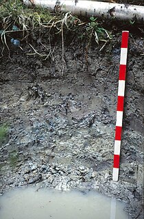
A gley is a wetland soil that, unless drained, is saturated with groundwater for long enough to develop a characteristic gleyic colour pattern. The pattern is essentially made up of reddish, brownish, or yellowish colours at surfaces of soil particles and/or in the upper soil horizons mixed with greyish/blueish colours inside the peds and/or deeper in the soil. Gleysols are also known as Gleyzems, meadow soils, Aqu-suborders of Entisols, Inceptisols and Mollisols, or as groundwater soils and hydro-morphic soils.
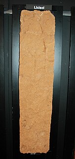
Lixisols are a Reference Soil Group of the World Reference Base for Soil Resources (WRB). They are soils with subsurface accumulation of low activity clays and high base saturation. They develop under intensive tropical weathering conditions and subhumid to semi-arid climate.

A Cambisol in the World Reference Base for Soil Resources (WRB) is a soil in the beginning of soil formation. The horizon differentiation is weak. This is evident from weak, mostly brownish discolouration and/or structure formation in the soil profile.
A Stagnosol in the World Reference Base for Soil Resources (WRB) is soil with strong mottling of the soil profile due to redox processes caused by stagnating surface water.
Andosols are soils found in volcanic areas formed in volcanic tephra. In some cases Andosols can also be found outside active volcanic areas. Andosols cover an estimated 1–2% of earth's ice-free land surface. Andosols are a Reference Soil Group of the World Reference Base for Soil Resources (WRB). They are closely related to other types of soils such as Vitrosols, Vitrandosols, Vitrons and Pumice Soils that are used in different soil classification systems. Poorly developed Andosols are often rich in vitreous materials and are therefore also called Vitric Andosols. The name comes from Japanese an and do, synonymous with kuroboku. In the USDA soil taxonomy, Andosols are known as Andisols.
An Alisol is a Reference Soil Group of the World Reference Base for Soil Resources (WRB).
Luvisols are a group of soils, comprising one of the 32 Reference Soil Groups in the international system of soil classification, the World Reference Base for Soil Resources (WRB). They are widespread, especially in temperate climates, and are generally fertile. Luvisols are widely used for agriculture.

A nitisol in the World Reference Base for Soil Resources (WRB) is a deep, red, well-drained soil with a clay content of more than 30% and a blocky structure. Nitisols correlate with the kandic alfisols, ultisols and inceptisols of the USDA soil taxonomy.
A Retisol is a Reference Soil Group of the World Reference Base for Soil Resources (WRB). Retisols are characterized by clay migration and an additional specific feature: The clay-poorer and lighter coloured eluvial horizon intercalates netlike into the clay-richer more intensely coloured illuvial horizon. The illuvial horizon is the diagnostic argic horizon, and the intercalation is called retic properties.


