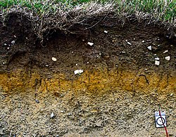
Stagnogley

Last updated
Stagnogley soil Stagnogley.JPG
Stagnogley soil
English oak near Wilsede, Germany Stieleiche bei Wilsede.jpg
English oak near Wilsede, Germany

A stagnogley soil is a typically non-alluvial, non-calcareous, loamy or clayey soil with a relatively impervious, subsurface horizon. [1] Stagnogley soils are related to the pseudogleys and are a type of gleyic soil. The name of this hygroscopic soil derives from its gley dynamics. The nutrient-poor, often heavily acidified soil is poorly aerated and is not suited to arable use on account of the poor growth performance of cultivated crops. [2] As a shallow topsoil with a moderately stony subsoil, [3] it is mainly used for woodland. [4] Because of its shallow nature it is only suitable for species of trees that thrive well in these conditions, such as the English Oak.

Contents

Formation

This type of soil, the topsoil of which becomes bleached as a result of continual waterlogging, is often formed on sand-rich material over dense, sandy-loamy to silty-clayey subsoil—also called Sandkerf in German—in cool, moist climatic zones. As a result of frequent waterlogging throughout the seasons at low temperatures, minerals like iron and magnesium are released and deposited in sandy topsoils to the sides. Where the soil is saturated all-year round it turns into bog stagnogley and, eventually, into bog. [2] Examples, known as missen occur in the Black Forest in Germany.

Extent

Stagnogley soils occur in perhumid climates and also on steep slopes. They are found, for example, in the central European Central Upland ranges of the Black Forest, Ore Mountains and Eifel in waterlogged places, as well as on the Midvale Ridge in the UK. Due to the discharge of heavy metals, they occur with oxigleys. [2]

Related Research Articles

<span class="mw-page-title-main">Bog</span> Type of wetland with peat-rich soil

A bog or bogland is a wetland that accumulates peat as a deposit of dead plant materials – often mosses, typically sphagnum moss. It is one of the four main types of wetlands. Other names for bogs include mire, mosses, quagmire, and muskeg; alkaline mires are called fens. A bayhead is another type of bog found in the forest of the Gulf Coast states in the United States. They are often covered in heath or heather shrubs rooted in the sphagnum moss and peat. The gradual accumulation of decayed plant material in a bog functions as a carbon sink.

<span class="mw-page-title-main">Podzol</span> Typical soils of coniferous or boreal forests

In soil science, podzols are the typical soils of coniferous or boreal forests and also the typical soils of eucalypt forests and heathlands in southern Australia. In Western Europe, podzols develop on heathland, which is often a construct of human interference through grazing and burning. In some British moorlands with podzolic soils, cambisols are preserved under Bronze Age barrows.

<span class="mw-page-title-main">Brown earth</span> Soil type

Brown earth is a type of soil. Brown earths are mostly located between 35° and 55° north of the Equator. The largest expanses cover western and central Europe, large areas of western and trans-Uralian Russia, the east coast of America and eastern Asia. Here, areas of brown earth soil types are found particularly in Japan, Korea, China, eastern Australia and New Zealand. Brown earths cover 45% of the land in England and Wales. They are common in lowland areas on permeable parent material. The most common vegetation types are deciduous woodland and grassland. Due to the reasonable natural fertility of brown earths, large tracts of deciduous woodland have been cut down and the land is now used for farming. They are normally located in regions with a humid temperate climate. Rainfall totals are moderate, usually below 76 cm per year, and temperatures range from 4 °C in the winter to 18 °C in the summer. They are well-drained fertile soils with a pH of between 5.0 and 6.5.

The Canadian System of Soil Classification is more closely related to the American system than any other, but they differ in several ways. The Canadian system is designed to cover only Canadian soils. The Canadian system dispenses with the sub-order hierarchical level. Solonetzic and Gleysolic soils are differentiated at the order level.

Tifton soil is the official state soil of the state of Georgia.

An agricultural drainage system is a system by which water is drained on or in the soil to enhance agricultural production of crops. It may involve any combination of stormwater control, erosion control, and watertable control.

<span class="mw-page-title-main">Raised bog</span> Type of wetland

Raised bogs, also called ombrotrophic bogs, are acidic, wet habitats that are poor in mineral salts and are home to flora and fauna that can cope with such extreme conditions. Raised bogs, unlike fens, are exclusively fed by precipitation (ombrotrophy) and from mineral salts introduced from the air. They thus represent a special type of bog, hydrologically, ecologically and in terms of their development history, in which the growth of peat mosses over centuries or millennia plays a decisive role. They also differ in character from blanket bogs which are much thinner and occur in wetter, cloudier climatic zones.

<span class="mw-page-title-main">Planosol</span> Soil type

A Planosol in the World Reference Base for Soil Resources is a soil with a light-coloured, coarse-textured, surface horizon that shows signs of periodic water stagnation and abruptly overlies a dense, slowly permeable subsoil with significantly more clay than the surface horizon. In the US Soil Classification of 1938 used the name Planosols, whereas its successor, the USDA soil taxonomy, includes most Planosols in the Great Groups Albaqualfs, Albaquults and Argialbolls.

<span class="mw-page-title-main">Stagnosol</span> Saturated soil type

A Stagnosol in the World Reference Base for Soil Resources (WRB) is soil with strong mottling of the soil profile due to redox processes caused by stagnating surface water.

<span class="mw-page-title-main">Woolmer Forest</span> Forest in Hampshire and West Sussex, England

Woolmer Forest is a 1,298.5-hectare (3,209-acre) biological Site of Special Scientific Interest south of Bordon in Hampshire and West Sussex. It is also a Special Area of Conservation and part of the Wealden Heaths Phase II Special Protection Area. Two areas are Nature Conservation Review sites, Grade I.

Missen are small, shallow, forest bogs in pine -dominated woods that form on crests, saddles, hollows or plateaus in the hills or mountains. They only have a thin layer of peat of between 30 and 100 centimetres thick. The term misse is local to the Northern Black Forest and also surfaces as Miß, Müsse or Müß. These names probably derive from the German Moos ("moss") because peat mosses (Sphagnum) play a key role in their development. Due to the poor tree growth associated with them, however, it could also stand for mies ("bad").

<i>Shorea robusta</i> seed oil

Shorea robusta seed oil is an edible oil extracted from the seeds of Shorea robusta. Shorea robusta is known as the Sal tree in India. Sal is indigenous to India and occurs in two main regions separated by the Gangetic Plain, namely the northern and central Indian regions. The plant belongs to the Dipterocarpaceae botanical family.

<span class="mw-page-title-main">Geology of Surrey</span>

The geology of Surrey is dominated by sedimentary strata from the Cretaceous, overlaid by clay and superficial deposits from the Cenozoic.

A Retisol is a Reference Soil Group of the World Reference Base for Soil Resources (WRB). Retisols are characterized by clay migration and an additional specific feature: The clay-poorer and lighter coloured eluvial horizon intercalates netlike into the clay-richer more intensely coloured illuvial horizon. The illuvial horizon is the diagnostic argic horizon, and the intercalation is called retic properties.

<span class="mw-page-title-main">Soil in Kilte Awula'ilo</span>

The soils of the Kilte Awula’ilo woreda (district) in Tigray, Ethiopia reflect its longstanding agricultural history, highly seasonal rainfall regime, relatively low temperatures, the presence of a wide depression at the foot of the Atsbi horst and steep slopes. Outstanding features in the soilscape are the wide ancient fluvial deposits, the soils of the granite batholith, cuestas and fertile lands behind tufa dams.

<span class="mw-page-title-main">Soil in Atsbi Wenberta</span>

The soils of the Atsbi Wenberta woreda (district) in Tigray (Ethiopia) reflect its longstanding agricultural history, highly seasonal rainfall regime and relatively low temperatures. The northern part of the district is on the high uplifted Atsbi Horst, whereas the southern part is dominated by the Des’a forest on Antalo Limestone. In between there is the fluvial landscape of Hayqi Meshal. Particularities in the southern part of the district are soil catenas on intervening plains behind tufa dams and in a polje.

The soils of the Inderta woreda (district) in Tigray (Ethiopia) reflect its longstanding agricultural history, highly seasonal rainfall regime, relatively low temperatures, overall dominance of limestone and dolerite lithologies and steep slopes. Outstanding features in the soilscape are wide plains with Vertisols.

<span class="mw-page-title-main">Soil in Tanqwa Abergele</span>

The soils of the Tanqwa Abergele woreda (district) in Tigray (Ethiopia) reflect its longstanding agricultural history, highly seasonal rainfall regime, relatively high temperatures, overall dominance of Precambrian metamorphic rocks and steep slopes.

<span class="mw-page-title-main">Soil in Dogu'a Tembien</span>

The soils of the Dogu’a Tembien woreda (district) in Tigray (Ethiopia) reflect its longstanding agricultural history, highly seasonal rainfall regime, relatively low temperatures, an extremely great variety in lithology and steep slopes. Outstanding features in the soilscape are the fertile highland Vertisols and Phaeozems in forests.

The Sassafras soil series is one of the oldest in the United States and has great historical significance to modern-day soil science. It was recognized as Maryland's state soil in 1901 and is now identified as a Benchmark and Hall of Fame soil series, which is a recognition given to a soil series for having a critical role in the evolution of soil science. It has been mapped in over 500,000 acres around Maryland and is also found in Pennsylvania, New Jersey, Delaware, Virginia, and Washington DC.

References

  1. Whittow, John (1984). Dictionary of Physical Geography. London: Penguin, 1984, p. 507. ISBN   0-14-051094-X.
  2. 1 2 3 Fritz Scheffer, Paul Schachtschabel: Lehrbuch der Bodenkunde. 15th edn., newly revised and expanded by Hans-Peter Blume. Spektrum, Heidelberg, etc., 2002, ISBN   3-8274-1324-9.
  3. BofaWeb [ permanent dead link ], Landesanstalt für Umwelt, Messungen und Naturschutz Baden-Württemberg, accessed on 1 August 2008
  4. Stagnogley in: Microsoft Encarta