Midvale Ridge

Last updated
The Old Golf Course on Boar's Hill with Oxford's spires in the distance Old Golf Course, Boar's Hill - geograph.org.uk - 129476.jpg
The Old Golf Course on Boar's Hill with Oxford's spires in the distance

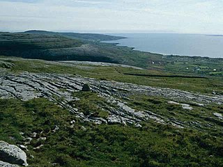
The Midvale Ridge is a natural region in South Central England formed by a band of low-lying limestone hills that run from southeast to northwest from the Vale of Aylesbury to Swindon. It has been designated as National Character Area 109 by Natural England, the UK Government's advisors on the natural environment.

Natural region region distinguished by its common natural features of geography, geology, and climate

A natural region is a basic geographic unit. Usually it is a region which is distinguished by its common natural features of geography, geology, and climate.

Limestone Sedimentary rocks made of calcium carbonate

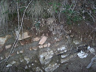
Limestone is a carbonate sedimentary rock that is often composed of the skeletal fragments of marine organisms such as coral, foraminifera, and molluscs. Its major materials are the minerals calcite and aragonite, which are different crystal forms of calcium carbonate (CaCO3). A closely related rock is dolostone, which contains a high percentage of the mineral dolomite, CaMg(CO3)2. In fact, in old USGS publications, dolostone was referred to as magnesian limestone, a term now reserved for magnesium-deficient dolostones or magnesium-rich limestones.

Swindon town in Wiltshire, England

Swindon is a large town in Wiltshire, South West England, between Bristol, 35 miles to the west, and Reading, the same distance to the east; the town is 71 miles (114 km) west of London. At the 2011 census, it had a population of 182,441. The Town Development Act 1952 led to a major increase in its population.

The Midvale Ridge crosses the counties of Wiltshire, Oxfordshire and Buckinghamshire. It is surrounded by the lowlands of the Oxfordshire clay vales and offers good views over the local countryside. The area is dominated by agriculture with a mixed arable/ pastoral farming landscape. Cereals are the most important arable crop. [1]

Wiltshire County of England

Wiltshire is a county in South West England with an area of 3,485 km2. It is landlocked and borders the counties of Dorset, Somerset, Hampshire, Gloucestershire, Oxfordshire and Berkshire. The county town was originally Wilton, after which the county is named, but Wiltshire Council is now based in the county town of Trowbridge.

Oxfordshire County of England

Oxfordshire is a county in South East England. The ceremonial county borders Warwickshire to the north-west, Northamptonshire to the north-east, Buckinghamshire to the east, Berkshire to the south, Wiltshire to the south-west and Gloucestershire to the west.

Buckinghamshire County of England

Buckinghamshire, abbreviated Bucks, is a ceremonial county in South East England which borders Greater London to the south east, Berkshire to the south, Oxfordshire to the west, Northamptonshire to the north, Bedfordshire to the north east and Hertfordshire to the east.

The main settlements are the town of Swindon in the west, and the city of Oxford, in the centre. Otherwise the area is relatively sparsely populated with small nucleated villages along the crest of the ridge and along the springline. Soils comprise a mix of heavy rendzinas, stagnogleys and lighter sandy brown earths with small patches of sandy soils. [1]

Rendzina soil type

Rendzina is a soil type recognized in various soil classification systems, including those of Britain and Germany as well as some obsolete systems. They are humus-rich shallow soils that are usually formed from carbonate- or occasionally sulfate-rich parent material. Rendzina soils are often found in karst and mountainous regions.

Stagnogley soil type

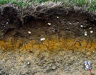
A stagnogley soil is a typically non-alluvial, non-calcareous, loamy or clayey soil with a relatively impervious, subsurface horizon. Stagnogley soils are related to the pseudogleys and are a type of gleyic soil. The name of this hygroscopic soil derives from its gley dynamics. The nutrient-poor, often heavily acidified soil is poorly aerated and is not suited to arable use on account of the poor growth performance of cultivated crops. As a shallow topsoil with a moderately stony subsoil, it is mainly used for woodland. Because of its shallow nature it is only suitable for species of trees that thrive well in these conditions, such as the English Oak.

The area has a number of important geological sites and has yielded fossils of international importance, including the holotypes for several ammonite species and several species of prehistoric sponges known only from the Faringdon area. [1]

Fossil Preserved remains or traces of organisms from a past geological age

A fossil is any preserved remains, impression, or trace of any once-living thing from a past geological age. Examples include bones, shells, exoskeletons, stone imprints of animals or microbes, objects preserved in amber, hair, petrified wood, oil, coal, and DNA remnants. The totality of fossils is known as the fossil record.

Holotype single physical example (or illustration) of an organism, known to have been used when the species (or lower-ranked taxon) was formally described

A holotype is a single physical example of an organism, known to have been used when the species was formally described. It is either the single such physical example or one of several such, but explicitly designated as the holotype. Under the International Code of Zoological Nomenclature (ICZN), a holotype is one of several kinds of name-bearing types. In the International Code of Nomenclature for algae, fungi, and plants (ICN) and ICZN the definitions of types are similar in intent but not identical in terminology or underlying concept.

Faringdon town in Oxfordshire

Faringdon is a historic market town in the Vale of White Horse, Oxfordshire, England. Within the historic boundaries of Berkshire, it is 18 miles (29 km) southwest of Oxford, 10 miles (16 km) northwest of Wantage and 12 miles (19 km) east-northeast of Swindon. It is a large parish, its lowest parts extending to the River Thames in the north and its highest ground reaching the Ridgeway in the south.

Related Research Articles

Geography of Hungary

With a land area of 93,030 square km, Hungary is a landlocked country in Central Europe. It measures about 250 km from north to south and 524 km from east to west. It has 2,106 km of boundaries, shared with Austria to the west, Serbia, Croatia and Slovenia to the south and southwest, Romania to the southeast, Ukraine to the northeast, and Slovakia to the north.

Vale of York

The Vale of York is an area of flat land in the northeast of England. The vale is a major agricultural area and serves as the main north-south transport corridor for Northern England.

North Downs ridge of chalk hills in south east England

The North Downs are a ridge of chalk hills in south east England that stretch from Farnham in Surrey to the White Cliffs of Dover in Kent. Westerham Heights, at the northern edge of the North Downs, near Bromley, South London, is the highest point in London at an elevation of 245 m (804 ft). The North Downs lie within two Areas of Outstanding Natural Beauty (AONBs), the Surrey Hills and the Kent Downs. The North Downs Way National Trail runs along the North Downs from Farnham to Dover.

Vale of White Horse Non-metropolitan district in England

The Vale of White Horse is a local government district of Oxfordshire in England. Located south of the River Thames, it is within the historic county boundaries of Berkshire.

Berkshire Downs

The Berkshire Downs are a range of chalk downland hills in southern England, part of the North Wessex Downs Area of Outstanding Natural Beauty. The Berkshire Downs are wholly within the traditional county of Berkshire, although split between the current ceremonial counties of Berkshire and Oxfordshire. The western parts of the downs are also known as the Lambourn Downs.

North Wessex Downs AONB located in the English counties of West Berkshire, Hampshire, Oxfordshire and Wiltshire

The North Wessex Downs Area of Outstanding Natural Beauty (AONB) is located in the English counties of Berkshire, Hampshire, Oxfordshire and Wiltshire. The name North Wessex Downs is not a traditional one, the area covered being better known by various overlapping local names, including the Berkshire Downs, the North Hampshire Downs, the White Horse Hills, the Lambourn Downs, the Marlborough Downs, the Vale of Pewsey and Savernake Forest.

Howardian Hills mountain range

The Howardian Hills are an Area of Outstanding Natural Beauty located between the Yorkshire Wolds, the North York Moors National Park and the Vale of York, they take their name from the Howard family who still own local lands.

A420 road road in England

The A420 is a road between Bristol and Oxford in England. Between Swindon and Oxford it is a primary route.

River Ock river in Oxfordshire, United Kingdom

The River Ock is a small English river which is a tributary of the River Thames. It has as its catchment area the Vale of White Horse, a low-lying and wide valley in south Oxfordshire, and flows into the River Thames, at Abingdon on the reach above Culham Lock.

Greensand Ridge sandstone escarpment and range of hills in south-east England

The Greensand Ridge is an extensive, prominent, often wooded, mixed greensand/sandstone escarpment in south-east England. It runs to and from the East Sussex coast, around the Weald, a former dense forest in Sussex, Surrey and Kent. It reaches its highest elevation, 294 metres (965 ft), at Leith Hill in Surrey—the second highest point in south-east England, while another hill in its range, Blackdown, is the highest point in Sussex at 280 metres (919 ft). The eastern end of the ridge forms the northern boundary of Romney Marsh.

Aston Rowant National Nature Reserve area in the Chiltern Hills, England

Aston Rowant National Nature Reserve is located on the north-west escarpment of the Chiltern Hills, in the Chilterns Area of Outstanding Natural Beauty. It has an area of 159.1 hectares, and most of it is a 128.5 hectare biological Site of Special Scientific Interest. It is listed as a Grade 1 site in A Nature Conservation Review. The reserve is in several sections, mostly in the parish of Lewknor in Oxfordshire, with smaller sections in the parish of Stokenchurch in Buckinghamshire.

Highgate Common

Highgate Common is a Staffordshire Wildlife Trust reserve containing a mix of heathland and woodland. It is about 129 hectares or 320 acres in size. The common is a popular leisure destination and a Site of Special Scientific Interest, located in Southern Staffordshire, England.

Ardington and Lockinge

Ardington and Lockinge are two civil parishes within the Vale of White Horse district, centred about 2 miles (3 km) east of Wantage, Oxfordshire, that share a parish council.

The Natural Areas of England are regions, officially designated by Natural England, each with a characteristic association of wildlife and natural features. More formally, they are defined as "biogeographic zones which reflect the geological foundation, the natural systems and processes and the wildlife in different parts of England...".

A National Character Area (NCA) is a natural subdivision of England based on a combination of landscape, biodiversity, geodiversity and economic activity. There are 159 National Character Areas and they follow natural, rather than administrative, boundaries. They are defined by Natural England, the UK government's advisors on the natural environment.

Shabbington Woods Complex

Shabbington Woods Complex is a 305.6 hectare biological Site of Special Scientific Interest ( between Horton-cum-Studley and Worminghall in Buckinghamshire. It comprises Shabbington Wood, Bernwood Forest, Hell Coppice, Oakley Wood and York's Wood. Shabbington Wood is owned by the Forestry Commission, and a small area of 7.5 hectares called Bernwood Meadows is managed by the Berkshire, Buckinghamshire and Oxfordshire Wildlife Trust.

Long Herdon Meadow

Long Herdon Meadow is a 4.5 hectare biological Site of Special Scientific Interest south of Marsh Gibbon in Buckinghamshire. It is part of Upper Ray Meadows nature reserve, which is managed by the Berkshire, Buckinghamshire and Oxfordshire Wildlife Trust.

Upper Ray Meadows

Upper Ray Meadows is a 181 hectare nature reserve, managed by the Berkshire, Buckinghamshire and Oxfordshire Wildlife Trust, south of Marsh Gibbon in Buckinghamshire. It is composed of a number of areas, one of which, Long Herdon Meadow, is a biological Site of Special Scientific Interest.

References

  1. 1 2 3 109 Midvale Ridge at www.naturalengland.org.uk. Accessed on 7 Oct 2013

Coordinates: 51°43′N1°17′W / 51.71°N 1.28°W / 51.71; -1.28

Geographic coordinate system Coordinate system

A geographic coordinate system is a coordinate system that enables every location on Earth to be specified by a set of numbers, letters or symbols. The coordinates are often chosen such that one of the numbers represents a vertical position and two or three of the numbers represent a horizontal position; alternatively, a geographic position may be expressed in a combined three-dimensional Cartesian vector. A common choice of coordinates is latitude, longitude and elevation. To specify a location on a plane requires a map projection.