List of U.S. state soils

Last updated

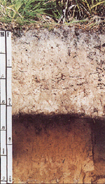
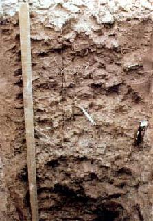
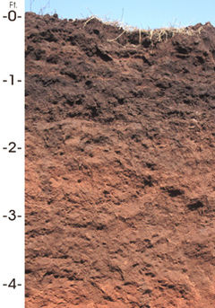
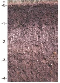
This is a list of U.S. state soils. A state soil is a soil that has special significance to a particular state. Each state in the United States has selected a state soil, twenty of which have been legislatively established. These official state soils share the same level of distinction as official state flowers and birds. Also, representative soils have been selected for Puerto Rico and the U.S. Virgin Islands. [1]

Contents

Table

State
federal district
or territory
State soilImageYear adopted as official
state symbol (if any)
Alabama Bama Bama soil.png 1997 [2]
Alaska Tanana
Arizona Casa Grande
Arkansas Stuttgart 1997
California San Joaquin SanJoaquinProfileSmall.png 1997
Colorado Seitz [3] Sloan Lake View from American Basin Trail.jpg
Connecticut Windsor proposed [4]
Delaware Greenwich 2000
Florida Myakka Myakka soil.jpg 1989
Georgia Tifton
Hawaii Hilo Hilo soil profile.jpg
Idaho Threebear
Illinois Drummer Drummer Soil Series - From USDA NRCS.jpg 2001
Indiana Miami Miami soil profile.jpg
Iowa Tama
Kansas Harney
Harney soil profile (Kansas State Soil).png
1990
Kentucky Crider Crider soil USDA NRCS profile.jpg 1990
Louisiana Ruston
Maine Chesuncook (soil) 1999
Maryland Sassafras
Massachusetts Paxton 1990
Michigan Kalkaska 1990
Minnesota Lester Lester soil USDA.png 2012
Mississippi Natchez 2003
Missouri Menfro Menfro soil USDA 1.jpg
Montana Scobey
Scobey Soil profile Scobey soil.jpg
Scobey Soil profile
2015 [5]
Nebraska Holdrege (soil) 1979
Nevada Orovada 2001
New Hampshire Marlow [6]
New Jersey Downer
New Mexico Penistaja
New York Honeoye
North Carolina Cecil Cecil-soil.jpg
North Dakota Williams
Ohio Miamian
Oklahoma Port Silt Loam Oklahoma state soil.JPG 1987
Oregon Jory JorySoilProfile.jpg 2011 [7] [8]
Pennsylvania Hazleton (soil)
Puerto Rico Bayamon
Rhode Island Narragansett
South Carolina Bohicket
South Dakota Houdek Houdek soil.jpg 1990
Tennessee Dickson
Texas Houston Black
Utah Mivida [9]
Vermont Tunbridge 1985
Virgin Islands Victory
Virginia Pamunkey
Washington Tokul Tokul Soil.png proposed [10]
West Virginia Monongahela 1997
Wisconsin Antigo Antigo (soil).jpg 1983
Wyoming Forkwood

See also

Related Research Articles

<span class="mw-page-title-main">United States Department of Agriculture</span> Department of the US government

The United States Department of Agriculture (USDA) is the federal executive department responsible for developing and executing federal laws related to farming, forestry, rural economic development, and food. It aims to meet the needs of commercial farming and livestock food production, promotes agricultural trade and production, works to assure food safety, protects natural resources, fosters rural communities and works to end hunger in the United States and internationally. It is headed by the Secretary of Agriculture, who reports directly to the President of the United States and is a member of the president's Cabinet. The current secretary is Tom Vilsack, who has served since February 24, 2021.

Natural Resources Conservation Service (NRCS), formerly known as the Soil Conservation Service (SCS), is an agency of the United States Department of Agriculture (USDA) that provides technical assistance to farmers and other private landowners and managers.

<span class="mw-page-title-main">Agricultural wastewater treatment</span> Farm management for controlling pollution from confined animal operations and surface runoff

Agricultural wastewater treatment is a farm management agenda for controlling pollution from confined animal operations and from surface runoff that may be contaminated by chemicals in fertilizer, pesticides, animal slurry, crop residues or irrigation water. Agricultural wastewater treatment is required for continuous confined animal operations like milk and egg production. It may be performed in plants using mechanized treatment units similar to those used for industrial wastewater. Where land is available for ponds, settling basins and facultative lagoons may have lower operational costs for seasonal use conditions from breeding or harvest cycles. Animal slurries are usually treated by containment in anaerobic lagoons before disposal by spray or trickle application to grassland. Constructed wetlands are sometimes used to facilitate treatment of animal wastes.

<span class="mw-page-title-main">Hugh Hammond Bennett</span> American soil scientist

Hugh Hammond Bennett was a pioneer in the field of soil conservation in the United States of America. He was the head of the Soil Conservation Service, a federal agency now referred to as the Natural Resources Conservation Service.

<span class="mw-page-title-main">Soil color</span> Morphological property of soil

Soil color is often the most visually apparent property of soil. While color itself does not influence the behavior or practical use of soils, it does indicate important information about the soil organic matter content, mineralogy, moisture, and drainage.

<span class="mw-page-title-main">National Cooperative Soil Survey</span> Program to understand and manage US soils

The National Cooperative Soil Survey Program (NCSS) in the United States is a nationwide partnership of federal, regional, state, and local agencies and institutions. This partnership works together to cooperatively investigate, inventory, document, classify, and interpret soils and to disseminate, publish, and promote the use of information about the soils of the United States and its trust territories. The activities of the NCSS are carried out on national, regional, and state levels.

Orovada series soil is the official state soil of Nevada. The soil series has an extent of 367,853 acres (148,865 ha), primarily in northern and central Nevada, and extending into southern Idaho and Oregon. They are common soils on semiarid rangeland with sagebrush-grassland plant communities. Orovada soils are arable, able to be cultivated, when irrigated and are considered prime farmland. Alfalfa for hay and seed, winter wheat, barley, and grasses for hay and pasture are the principal crops grown on these soils.

<span class="mw-page-title-main">Klamath Basin</span> Region in the U.S. states of Oregon and California drained by the Klamath River

The Klamath Basin is the region in the U.S. states of Oregon and California drained by the Klamath River. It contains most of Klamath County and parts of Lake and Jackson counties in Oregon, and parts of Del Norte, Humboldt, Modoc, Siskiyou, and Trinity counties in California. The 15,751-square-mile (40,790 km2) drainage basin is 35% in Oregon and 65% in California. In Oregon, the watershed typically lies east of the Cascade Range, while California contains most of the river's segment that passes through the mountains. In the Oregon-far northern California segment of the river, the watershed is semi-desert at lower elevations and dry alpine in the upper elevations. In the western part of the basin, in California, however, the climate is more of temperate rainforest, and the Trinity River watershed consists of a more typical alpine climate.

<span class="mw-page-title-main">Bama (soil)</span>

Bama is the official state soil of Alabama.

<span class="mw-page-title-main">Christmas tree cultivation</span> Cultivation of trees used as Christmas trees

Christmas tree cultivation is an agricultural, forestry, and horticultural occupation which involves growing pine, spruce, and fir trees specifically for use as Christmas trees.

The Alabama Department of Conservation and Natural Resources (ADCNR) is the state agency responsible for the conservation and management of Alabama's natural resources including state parks, state lands, wildlife and aquatic resources. ADCNR also issues hunting and fishing licenses for the state. The department promotes wise stewardship and enjoyment of the state's natural resources through five divisions: Marine Resources, State Lands, State Parks and Wildlife and Freshwater Fisheries. Supporting those divisions are seven support sections: Accounting, Diversity and Recruiting, Engineering, Information and Education, Information Technology, Legal, and Personnel and Payroll.

<span class="mw-page-title-main">Conservation Effects Assessment Project</span> United States government project

The Conservation Effects Assessment Project (CEAP) was established in 2002 to quantify the environmental impact of the United States Department of Agriculture's (USDA) conservation program. The project focuses on how watersheds are affected. CEAP monitored 14 benchmark watershed sites. The CEAP's vision is to enhance "natural resources and healthier ecosystems through improved conservation effectiveness and better management of agricultural landscapes. The goal is "to improve efficacy of conservations practices and programs by quantifying conservation effects and providing the science and education base needed to enrich conservation planning, implementation, management decisions, and policy."

The Conservation Security Program (CSP) was a voluntary conservation program in the United States that supported stewardship of private agricultural lands by providing payments and technical assistance for maintaining and enhancing natural resources. The program promoted the conservation and improvement of soil, water, air, energy, plant and animal life, and other conservation purposes. Congress established the CSP under the Farm Security and Rural Investment Act of 2002 (FSRIA), which amended the Food Security Act of 1985. The program was administered by the Natural Resources Conservation Service (NRCS), an agency of the United States Department of Agriculture (USDA).

<span class="mw-page-title-main">Jory (soil)</span>

The Jory series consists of very deep, well-drained soils that formed in colluvium derived from basic igneous rock. These soils are in the foothills surrounding the Willamette Valley of the United States. They have been mapped on more than 300,000 acres (1,200 km2) in western Oregon. They are named after Jory Hill, Marion County, Oregon, which itself is named for the Jory family, who settled in the area in 1852, after traveling along the Oregon Trail.

<span class="mw-page-title-main">Environmental Quality Incentives Program</span> United States government program

The Environmental Quality Incentives Program (EQIP) is a United States government program designed to assist farmers in improving environmental quality, particularly water quality and soil conservation. Congress established the program in the 1996 farm bill to provide primarily cost-sharing assistance, but also technical and educational assistance, aimed at promoting production and environmental quality, and optimizing environmental benefits.

Sloanea berteroana is a tree of the Caribbean region. The name is often misspelled as Sloanea berteriana. Its vernacular names include montillo and bullwood. It is native to Puerto Rico. This tree is common in the Toro Negro State Forest.

Ardilla is an unincorporated community in Houston County, Alabama, United States. Ardilla is located along Alabama State Route 53, 1 mile southeast of Ross Clark Circle in Dothan.

Lucy is an unincorporated community in Houston County, Alabama, United States.

Wicksburg, also spelled Wicksburgh, is an unincorporated community in Houston County, Alabama, United States. Wicksburg is located along Alabama State Route 103, 13.5 miles (21.7 km) west of Dothan.

References

  1. "State Soils". U.S. Department of Agriculture. Archived from the original on 2007-03-13. Retrieved 2007-03-11.
  2. "Official Alabama Soil". Alabama Emblems, Symbols and Honors. Alabama Department of Archives & History. 2004-06-15. Retrieved 2007-03-21.
  3. "Seitz -- Colorado State Soil". Natural Resources Conservation Service, United States Department of Agriculture. August 23, 2022. Retrieved May 12, 2023.
  4. "Windsor – Proposed State Soil". Connecticut Soils. Natural Resources Conservation Service. Archived from the original on 2007-07-31. Retrieved 2007-03-21.
  5. "LAWS Detailed Bill Information Page". laws.leg.mt.gov. Retrieved 2017-06-14.
  6. "Marlow" . Retrieved 2019-03-27.
  7. "House Concurrent Resolution 3, 2011". Oregon State Legislature. 2011. Archived from the original on August 5, 2012. Retrieved May 24, 2011.
  8. Mapes, Jeff (May 24, 2011). "Jory soil, not just any dirt, is named Oregon's state soil". The Oregonian . Retrieved May 24, 2011.
  9. "Soils | NRCS Utah". www.ut.nrcs.usda.gov. Retrieved 2016-12-16.
  10. "Tokul – Washington State Soil" (PDF). State Soils. Natural Resources Conservation Service . Retrieved 2007-03-21.[ permanent dead link ]