Houdek (soil)

Last updated
A 4-foot (1.2 m) cross section of Houdek loam Houdek soil.jpg
A 4-foot (1.2 m) cross section of Houdek loam

Houdek is a type of soil composed of glacial till and decomposed organic matter. The soil series was established in 1955 in Spink County, South Dakota. [1] It is unique to the United States, but in particular to South Dakota where it is the state soil.

Contents

Surface layer
Dark grayish brown loam
Subsoil - upper
Dark grayish brown clay loam
Subsoil - middle
Grayish brown clay loam
Subsoil - lower
Light olive brown clay loam
Substratum
Light yellowish brown clay loam

South Dakota State Soil

The soil forming factors provide a unique landscape in South Dakota which gives rise to more than 550 different soils. [2] The Houdek soil was designated as the South Dakota State Soil in 1990, by Governor George Mickelson of the State Legislature. The House Bill was signed into law, making the Houdek loam South Dakota's Official State Soil. [1]

This soil and others in the same location have been mapped on about 600,000 acres. The Professional Soil Scientists Association of SD and the SD Chapter of the Soil and Water Conservation Society worked together to commemorate the importance of soil to South Dakota. It is appropriate that Houdek loam was adopted as the state soil to bring acknowledgement to the important role it has played in South Dakota's most important industry, agriculture. [1]

Classification and Genesis

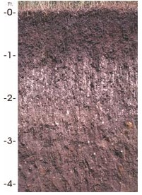
Houdek topsoil is composed of weathered glacial till and 2% to 4% organic matter which gives it a deep, dark color. The slopes ranges from 0 to 25 percent depending on location. [3] The subsoil consists of layers of clay and lime accumulations that were carried downward from the surface by water. Below these layers is the parent material called glacial till. The family name is fine-loamy, mixed, superactive, mesic Typic Argiustoll. [3]

The Houdek soil series is deep, well drained, loamy soil that represents many soils formed in South Dakota under grass vegetation. The dark color of the surface layer is a result of decomposition of biomass from vegetation and other materials that have been deposited over thousands of years. [1] Prairie conditions form a thick, dark colored, humified surface horizon or layer that is humus rich (1 to 4% organic C). This is a key characteristic that makes these soils fertile. [4]

Characteristics: The depth to carbonates ranges from 14 to 24 inches. Thickness of the mollic epipedon ranges from 8 to 20 inches and includes all or part of the Bt horizon. The soil contains 0 to 10 percent by volume of coarse fragments as pebbles. Some pedons contain up to 20 percent by volume of stones throughout. [3]

The A horizon has hue of 10YR, value of 3 to 5 and 2 or 3 moist, and chroma of 1 or 2. It typically is loam or silt loam but is clay loam in some pedons. It is slightly acid or neutral. [3]

1) Clay accumulation layer

The Bt horizon has hue of 10YR or 2.5Y, value of 4 to 6 and 3 to 5 moist, and chroma of 2 or 3. It is clay loam averaging between 27 and 35 percent clay. Some pedons have thin horizons that exceed 35 percent clay. It is neutral or slightly alkaline. [3]

2) Lime accumulation layer. As the Houdek soils weathered and formed, water from the soil surface carried lime and clay downward. These materials were deposited deeper, forming the two subsoil layers. [1]

The Bk horizon has hue of 10YR or 2.5Y, value of 4 to 6 and 4 or 5 moist, and chroma of 2 to 4. It is clay loam or loam and is slightly or moderately alkaline. It contains few to many, fine or medium accumulations of carbonate. [3]

The last layer in the Houdek soil is the parent material. This layer represents the materials from which the Houdek soil has developed with time. It represents what the glacier originally left at the soil surface. Climate factors and vegetation/soil organisms have weathered the glacial parent materials to form the present day Houdek soil. [1]

The C horizon has hue of 10YR, 2.5Y, or 5Y, value of 5 to 7 and 4 to 6, and chroma of 2 to 4. It is loam or clay loam and is slightly or moderately alkaline. It has few to many mottles inherent to the parent till. It has few or common accumulations of gypsum between depths of 40 and 60 inches in most pedons. [3]

The classic Houdek soil profile includes: a 6-8 inch friable, neutral, black loam topsoil; a 10 to 15 inch friable, neutral, dark brown clay loam subsoil; a 15 to 30 inch friable, calcareous, moderately alkaline, olive brown clay loam subsoil; and 20+ inches of friable, light olive brown, calcareous, moderately alkaline clay loam parent material. [1]

Geomorphology

The Pleistocene (1.5 - 10,000 B.C.) in Northern America was tilled by a succession of great ice sheets. [5] The area covered by glaciers in North America is estimated at 10.4 million km2 and about 20% of the U.S. is influenced by the deposits. [5] The retreating glaciers created the unconsolidated rock surface east of the Missouri River. It took the sediment numerous glacial advances and retreats beginning some 1.5 million years ago, and ending 10 thousand years ago to create glacial tilled soils. [6] Eastern South Dakota has a thick layer of glacial sediment that is about 100 feet (30 meters). [6] The glacial till is a result of the material deposited directly by the ice. The mixture of rock has a diverse range of particle size.

Climate and Vegetation

The average annual air temperature is about 48 degrees F and the average annual precipitation is 22 inches. [1] Due to its high storage of water that is plant available no irrigation is needed during the growing season to sustain at least three months of perennial grasses ranging from tall, mid, or short species. The amount of precipitation is sufficient to provide good production of organic residues but not enough to cause severe weathering and leaching. [4] The climate and vegetation have interacted in South Dakota to produce seven major soil regions. These regions are named: Cool Moist Forest; Cool, Very Dry Plain; Warm, Very Dry Plain; Cool Dry Plain; Warm Dry Plain; Cool Moist Prairie; and Warm Moist Prairie. [2]

Houdek soils are recognized for their uses for cropland and rangeland. Common crops grown are small grains, sunflowers, corn and soybeans are commonly grown crops. Livestock graze pastures of Alfalfa and other native grasses. Large areas of Houdek soils are also composed of native range. Crops and grasses grown on the Houdek soil also provide habitat for wildlife. Some native vegetation consist of big bluestem, little bluestem, western wheatgrass, green needlegrass, needle and thread, sideoats grama, blue grama, sedges, and forbs. [3]

Economic Importance

The Houdek soil is of major economic importance to South Dakota because it is often used as to grow small grain, corn, sunflowers, and soybeans. [3] South Dakota is well known as an agricultural state with an area of 77, 047 square miles and it has a population density of nine persons per square mile. Cash receipts from farming and ranching normally exceeds $3 billion each year. [1] On the average, South Dakota is recognized nationally in the top ten for corn, soybeans, spring wheat, oat, alfalfa hay, all hay, grain sorghum, sunflower seed, barley, rye, and flaxseed production. [1] With such soil fertile soil comes premium forage for livestock which is why South Dakota also comes in top ten for beef, sheep, hog, and honey production. [1] Houdek loam soil is the foundation of life and the economic base for South Dakota. Houdek loam is a symbol that can help increase public awareness and importance of South Dakota's soil resources. [1]

See also

Related Research Articles

<span class="mw-page-title-main">Tunbridge, Vermont</span> Town in Vermont, United States

Tunbridge is a town in Orange County, Vermont, United States. As of the 2020 United States Census the town population was 1,337. The town consists of three village centers, all situated on Vermont Route 110 in the valley of the first branch of the White River. The three settlements are named North Tunbridge, Tunbridge Village ("Market") and South Tunbridge ("Jigger").

Tilth is a physical condition of soil, especially in relation to its suitability for planting or growing a crop. Factors that determine tilth include the formation and stability of aggregated soil particles, moisture content, degree of aeration, soil biota, rate of water infiltration and drainage. Tilth can change rapidly, depending on environmental factors such as changes in moisture, tillage and soil amendments. The objective of tillage is to improve tilth, thereby increasing crop production; in the long term, however, conventional tillage, especially plowing, often has the opposite effect, causing the soil carbon sponge to oxidize, break down and become compacted.

<span class="mw-page-title-main">Till plain</span> Plain of glacial till

Till plains are an extensive flat plain of glacial till that forms when a sheet of ice becomes detached from the main body of a glacier and melts in place, depositing the sediments it carried. Ground moraines are formed with melts out of the glacier in irregular heaps, forming rolling hills. Till plains are common in areas such as the Midwestern United States, due to multiple glaciation events that occurred in the Holocene epoch. During this period, the Laurentide Ice Sheet advanced and retreated during the Pleistocene epoch. Till plains formed by the Wisconsin glaciation cover much of the Midwest, including North Dakota, South Dakota, Indiana, Minnesota, Wisconsin, Iowa, Illinois, and northern Ohio.

A soil horizon is a layer parallel to the soil surface whose physical, chemical and biological characteristics differ from the layers above and beneath. Horizons are defined in many cases by obvious physical features, mainly colour and texture. These may be described both in absolute terms and in terms relative to the surrounding material, i.e. 'coarser' or 'sandier' than the horizons above and below.

<span class="mw-page-title-main">World Reference Base for Soil Resources</span> International soil classification system

The World Reference Base for Soil Resources (WRB) is an international soil classification system for naming soils and creating legends for soil maps. The currently valid version is the fourth edition 2022. It is edited by a working group of the International Union of Soil Sciences (IUSS).

This is an index of articles relating to soil.

<span class="mw-page-title-main">Subsoil</span> Layer of soil under the topsoil on the surface of the ground

Subsoil is the layer of soil under the topsoil on the surface of the ground. Like topsoil, it is composed of a variable mixture of small particles such as sand, silt and clay, but with a much lower percentage of organic matter and humus, and it has a small amount of rocks which are smaller mixed with it. The subsoil is also called B Horizon.

<span class="mw-page-title-main">Cecil (soil)</span>

Originally mapped in Cecil County, Maryland in 1899, more than 10 million acres (40,000 km2) of the Cecil soil series are now mapped in the Piedmont region of the southeastern United States. It extends from Virginia through North Carolina, South Carolina, Georgia and Alabama, with the typic Cecil pedon actually located in Franklin County, NC.

<span class="mw-page-title-main">Soil morphology</span> Study of physical properties of soils

Soil morphology is the branch of soil science dedicated to the technical description of soil, particularly physical properties including texture, color, structure, and consistence. Morphological evaluations of soil are typically performed in the field on a soil profile containing multiple horizons.

<span class="mw-page-title-main">Soil color</span> Morphological property of soil

Soil color is often the most visually apparent property of soil. While color itself does not influence the behavior or practical use of soils, it does indicate important information about the soil organic matter content, mineralogy, moisture, and drainage.

Orovada series soil is the official state soil of Nevada. The soil series has an extent of 367,853 acres (148,865 ha), primarily in northern and central Nevada, and extending into southern Idaho and Oregon. They are common soils on semiarid rangeland with sagebrush-grassland plant communities. Orovada soils are arable, able to be cultivated, when irrigated and are considered prime farmland. Alfalfa for hay and seed, winter wheat, barley, and grasses for hay and pasture are the principal crops grown on these soils.

<span class="mw-page-title-main">San Joaquin (soil)</span>

San Joaquin is an officially designated state insignia, the state soil of the U.S. state of California.

The Canadian System of Soil Classification is more closely related to the American system than any other, but they differ in several ways. The Canadian system is designed to cover only Canadian soils. The Canadian system dispenses with the sub-order hierarchical level. Solonetzic and Gleysolic soils are differentiated at the order level.

In 1988, the Professional Soil Classifiers Association of Mississippi selected Natchez silt loam soil to represent the soil resources of the State. These soils exist on 171,559 acres (69,427 ha) of landscape in Mississippi.

<span class="mw-page-title-main">Albeluvisols</span> Soil type

Albeluvisol was a Reference Soil Group of the first edition (1998) and the second edition (2006) of the World Reference Base for Soil Resources (WRB). In the third edition of the WRB (2014), Albeluvisols were replaced by the broader defined Retisols. An Albeluvisol is a soil with a thin, dark surface horizon on a bleached subsurface horizon that tongues into a clay illuviation (Bt) horizon. The Bt horizon has an irregular or broken upper boundary resulting from the tonguing of bleached soil material into the illuviation horizon. Albeluvisols correlate with Glossaqualfs, Glossocryalfs and Glossudalfs in the USDA soil taxonomy.

<span class="mw-page-title-main">Stagnosol</span> Saturated soil type

A Stagnosol in the World Reference Base for Soil Resources (WRB) is soil with strong mottling of the soil profile due to redox processes caused by stagnating surface water.

The Olympic soil series is a type of deep, dark reddish brown moderately fine-textured soil which has developed on mafic rock such as basalt. The series covers large areas in southwestern Washington and western Oregon, and usually supports forests of Douglas-fir, red alder, western redcedar, western hemlock, and bigleaf maple.

<span class="mw-page-title-main">Geology of Rhode Island</span>

The geology of Rhode Island is based on nearly one billion year old igneous crystalline basement rocks formed as part of the microcontinent Avalonia that collided with the supercontinent Gondwana. The region experienced substantial folding associated with its landlocked position during the Alleghanian orogeny mountain building event. The region accumulated sedimentary rocks, including small deposits of coal. The region was covered with thick Atlantic Coastal Plain sediments, with the erosion of the Appalachians and the creation of the Atlantic Ocean throughout the past 200 million years. These surficial sediments and soils were substantially reworked by the Pleistocene glaciations. The state's geology is part of the broader geology of New England.

<span class="mw-page-title-main">Western Corn Belt Plains</span>

The Western Corn Belt Plains is a Level III ecoregion designated by the Environmental Protection Agency (EPA) in seven U.S. states, though predominantly in Iowa.

References

  1. 1 2 3 4 5 6 7 8 9 10 11 12 "Houdek Loam: THE STATE SOIL of SOUTH DAKOTA".
  2. 1 2 "Soils of South Dakota". The Northern State University CUEST Center for Environmental Education.[ permanent dead link ]
  3. 1 2 3 4 5 6 7 8 9 "Houdek Series". National Cooperative Soil Survey.
  4. 1 2 Malo, Douglas (2010). "South Dakota Soils: Their Genesis, Classification, and Management". CNU Journal of Agricultural Science.
  5. 1 2 "Sabine Grunwald". soils.ifas.ufl.edu. Retrieved 2015-12-17.
  6. 1 2 "The geology of South Dakota". Archived from the original on 2006-06-18. Retrieved 2015-12-17.

Bibliography