Description
The Natchez soils formed in very deep loess material under a woodland environment and a climate that was warm and humid. These soils have natural fertility and desirable tilth but usually occur on slopes that limit their use to trees. In areas where slopes are less, pasture and row crops are grown and the soil is very productive when good management is applied.

Loess is a clastic, predominantly silt-sized sediment that is formed by the accumulation of wind-blown dust. Ten percent of the Earth's land area is covered by loess or similar deposits.
Soil tilth is its physical condition of soil, especially in relation to its suitability for planting or growing a crop. Factors that determine tilth include the formation and stability of aggregated soil particles, moisture content, degree of aeration, rate of water infiltration and drainage. Tilth can change rapidly, depending on environmental factors such as changes in moisture, tillage and soil amendments. The objective of tillage is to improve tilth, thereby increasing crop production; in the long term, however, conventional tillage, especially plowing, often has the opposite effect, causing the soil to break down and become compacted.

Pasture is a concrete spatial area where farmers keep livestock for grazing.
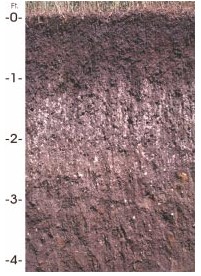
A typical Natchez soil profile consists of a 3 inch top soil of dark grayish brown silt loam and to 8 inches, a subsurface of brown silt loam, a yellowish brown and dark yellowish brown silt loam subsoil to 36 inches and a substratum that is yellowish brown, and dark yellowish brown silt loam down to 80 inches.
Soil family classification
Classified as coarse-silty, mixed, superactive, thermic typic eutrudepts:
Natchez soils are in the Inceptisols soil order. Inceptisols soils have developed in relatively young material that have an Ochric epipedon is rich in weatherable minerals. The term coarse-silty indicates that the subsoil has less than 18 percent clay with less than 15 percent sand coarser than very fine. The term mixed suggests that no one mineral is over 60 percent. Thermic refers to an average annual soil temperature between 15 and 22 degrees Celsius (59 to 72 degrees Fahrenheit) and differs more than 5 degrees Celsius (9 °F) between winter and summer at 50 cm (20 inches) below the surface.
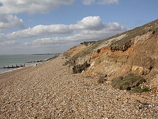
Natchez soils are on strongly sloping to very steep hillsides in the highly dissected parts of the bluff hills that border the Mississippi Delta floodplains. They formed in silty loess material that ranges from strongly acid to neutral in the upper part and neutral to slightly alkaline in lower parts. Average annual precipitation is 52 inches. Average annual air temperature is 63 °F (17 °C). The soil has developed in the upper Pleistocene age material.
This page is based on this
Wikipedia article Text is available under the
CC BY-SA 4.0 license; additional terms may apply.
Images, videos and audio are available under their respective licenses.

Loam is soil composed mostly of sand, silt, and a smaller amount of clay. By weight, its mineral composition is about 40–40–20% concentration of sand-silt-clay, respectively. These proportions can vary to a degree, however, and result in different types of loam soils: sandy loam, silty loam, clay loam, sandy clay loam, silty clay loam, and loam. In the USDA textural classification triangle, the only soil that is not predominantly sand, silt, or clay is called "loam". Loam soils generally contain more nutrients, moisture, and humus than sandy soils, have better drainage and infiltration of water and air than silt and clay-rich soils, and are easier to till than clay soils. The different types of loam soils each have slightly different characteristics, with some draining liquids more efficiently than others. The soil's texture, especially its ability to retain nutrients and water are crucial. Loam soil is suitable for growing most plant varieties.
This is an index of articles relating to soil.
Stuttgart soil series is an officially designated state symbol, the State Soil of Arkansas.

Originally mapped in Cecil County, Maryland in 1899, more than 10 million acres (40,000 km²) of the Cecil soil series are now mapped in the Piedmont region of the southeastern United States. It extends from Virginia through North Carolina, South Carolina, Georgia and Alabama, with the typic Cecil pedon actually located in Franklin County, NC. A map showing the actual extent of the Cecil series is available at the Center for Environmental Informatics
Soil texture is a classification instrument used both in the field and laboratory to determine soil classes based on their physical texture. Soil texture can be determined using qualitative methods such as texture by feel, and quantitative methods such as the hydrometer method. Soil texture has agricultural applications such as determining crop suitability and to predict the response of the soil to environmental and management conditions such as drought or calcium (lime) requirements. Soil texture focuses on the particles that are less than two millimeters in diameter which include sand, silt, and clay. The USDA soil taxonomy and WRB soil classification systems use 12 textural classes whereas the UK-ADAS system uses 11. These classifications are based on the percentages of sand, silt, and clay in the soil..
Downer is the New Jersey state soil. The Downer has four soil horizons:

San Joaquin is an officially designated state insignia, the state soil of the U.S. state of California.
Narragansett soils are loamy soils occurring in the northeastern United States. It is the state soil of Rhode Island.
The Paxton soil series was established in Worcester County, Massachusetts in 1922, and is named for the town of Paxton where it was first described and mapped.
Tifton soil is the official state soil of the state of Georgia.

Aster alpinus is an ornamental plant native to the mountains of Europe, with a subspecies native to Canada and the United States. It is a perennial forb having purple, pink or blue flowers belonging to the genus Aster.
A fragipan is a diagnostic horizon in USDA soil taxonomy. They are altered subsurface soil layers that restrict water flow and root penetration. Fragipans are similar to a duripan in how they affect land-use limitations. In soil descriptions, they are commonly denoted by a Bx or Btx symbol. They often form in loess ground. The first record of fragipans is probably that by John Hardcastle in New Zealand in the 1880s.
Brickearth is a term originally used to describe superficial windblown deposits found in southern England. The term has been employed in English-speaking regions to describe similar deposits.
Houdek is a type of soil composed of glacial till and decomposed organic matter. It is found only in the U.S. state of South Dakota where it is the state soil. The soil series was established in 1955 in Spink County, South Dakota. It is unique to the United States, but in particular to South Dakota where it is the state soil.

The Jory series consists of very deep, well-drained soils that formed in colluvium derived from basic igneous rock. These soils are in the foothills surrounding the Willamette Valley of the United States. They have been mapped on more than 300,000 acres (1,200 km2) in western Oregon. They are named after Jory Hill, Marion County, Oregon, which itself is named for the Jory family, who settled in the area in 1852, after traveling along the Oregon Trail.
The Drummer soil series is the state soil of Illinois.
The Holdrege silt loam is the state soil of Nebraska since 1979.

