Miami (soil)

Last updated
Miami soil profile Miami soil profile.jpg
Miami soil profile

The Miami soil series is the state soil of Indiana.

Soil series succession of soil horizons

Soil series as established by the National Cooperative Soil Survey of the United States Department of Agriculture (USDA) Natural Resources Conservation Service are a level of classification in the USDA Soil Taxonomy classification system hierarchy. The actual object of classification is the so-called soil individual, or pedon. Soil series consist of pedons that are grouped together because of their similar pedogenesis, soil chemistry, and physical properties. More specifically, each series consists of pedons having soil horizons that are similar in soil color, soil texture, soil structure, soil pH, consistence, mineral and chemical composition, and arrangement in the soil profile. These result in soils which perform similarly for land use purposes.

Indiana state of the United States of America

Indiana is a U.S. state in the Midwestern and Great Lakes regions of North America. Indiana is the 38th-largest by area and the 17th-most populous of the 50 United States. Its capital and largest city is Indianapolis. Indiana was admitted to the United States as the 19th U.S. state on December 11, 1816. Indiana borders Lake Michigan to the northwest, Michigan to the north, Ohio to the east, Kentucky to the south and southeast, and Illinois to the west.

Contents

The less sloping Miami soils are used mainly for corn, soybeans, or winter wheat. The steeper areas are used as pasture, hayland, or woodland. Significant area has been converted to residential and commercial uses. There are 794,994 acres (3,217 km2) of Miami soils mapped in Indiana.

Maize Cereal grain

Maize, also known as corn, is a cereal grain first domesticated by indigenous peoples in southern Mexico about 10,000 years ago. The leafy stalk of the plant produces pollen inflorescences and separate ovuliferous inflorescences called ears that yield kernels or seeds, which are fruits.

Winter wheat A general term for wheat sown in the fall, persisting through the winter as seedlings, and harvested the following spring or summer after it reaches full maturity.

Winter wheat are strains of wheat that are planted in the autumn to germinate and develop into young plants that remain in the vegetative phase during the winter and resume growth in early spring. Classification into spring or winter wheat is common and traditionally refers to the season during which the crop is grown. For winter wheat, the physiological stage of heading is delayed until the plant experiences vernalization, a period of 30 to 60 days of cold winter temperatures.

Pasture land used for grazing

Pasture is land used for grazing. Pasture lands in the narrow sense are enclosed tracts of farmland, grazed by domesticated livestock, such as horses, cattle, sheep, or swine. The vegetation of tended pasture, forage, consists mainly of grasses, with an interspersion of legumes and other forbs. Pasture is typically grazed throughout the summer, in contrast to meadow which is ungrazed or used for grazing only after being mown to make hay for animal fodder. Pasture in a wider sense additionally includes rangelands, other unenclosed pastoral systems, and land types used by wild animals for grazing or browsing.

Miami soils formed in calcareous, loamy till on the Wisconsin Till Plains. The native vegetation is hardwood forest. Miami soils are fertile and have a moderate available water capacity. Indiana is nationally ranked for agricultural production because of the highly productive Miami soils along with other prime farmland soils in the State. [1]

Pedogenesis is the process of soil formation as regulated by the effects of place, environment, and history. Biogeochemical processes act to both create and destroy order (anisotropy) within soils. These alterations lead to the development of layers, termed soil horizons, distinguished by differences in color, structure, texture, and chemistry. These features occur in patterns of soil type distribution, forming in response to differences in soil forming factors.

Calcareous An adjective meaning mostly or partly composed of calcium carbonate

Calcareous is an adjective meaning "mostly or partly composed of calcium carbonate", in other words, containing lime or being chalky. The term is used in a wide variety of scientific disciplines.

Loam Soil composed of similar proportions of sand and silt, and somewhat less clay

Loam is soil composed mostly of sand, silt, and a smaller amount of clay. By weight, its mineral composition is about 40–40–20% concentration of sand–silt–clay, respectively. These proportions can vary to a degree, however, and result in different types of loam soils: sandy loam, silty loam, clay loam, sandy clay loam, silty clay loam, and loam. In the USDA textural classification triangle, the only soil that is not predominantly sand, silt, or clay is called "loam". Loam soils generally contain more nutrients, moisture, and humus than sandy soils, have better drainage and infiltration of water and air than silt and clay-rich soils, and are easier to till than clay soils. The different types of loam soils each have slightly different characteristics, with some draining liquids more efficiently than others. The soil's texture, especially its ability to retain nutrients and water are crucial. Loam soil is suitable for growing most plant varieties.

The Miami series consists of moderately well drained soils formed in as much as 18 inches (46 cm) of loess or silty material and in the underlying loamy till on till plains. They are very deep soils that are moderately deep to dense till. Permeability is moderate or moderately slow in the solum, and slow or very slow in the underlying dense till. Slope ranges from 0 to 60%. Mean annual precipitation is 40 inches (1000 mm), and mean annual temperature is 52 °F (11 °C).

Loess A predominantly silt-sized clastic sediment of accumulated wind-blown dust

Loess is a clastic, predominantly silt-sized sediment that is formed by the accumulation of wind-blown dust. Ten percent of the Earth's land area is covered by loess or similar deposits.

Silt is granular material of a size between sand and clay, whose mineral origin is quartz and feldspar. Silt may occur as a soil or as sediment mixed in suspension with water and soil in a body of water such as a river. It may also exist as soil deposited at the bottom of a water body, like mudflows from landslides. Silt has a moderate specific area with a typically non-sticky, plastic feel. Silt usually has a floury feel when dry, and a slippery feel when wet. Silt can be visually observed with a hand lens, exhibiting a sparkly appearance. It also can be felt by the tongue as granular when placed on the front teeth.

Granular material conglomeration of discrete solid, macroscopic particles

A granular material is a conglomeration of discrete solid, macroscopic particles characterized by a loss of energy whenever the particles interact. The constituents that compose granular material are large enough such that they are not subject to thermal motion fluctuations. Thus, the lower size limit for grains in granular material is about 1 μm. On the upper size limit, the physics of granular materials may be applied to ice floes where the individual grains are icebergs and to asteroid belts of the Solar System with individual grains being asteroids.

Miami soils are classified in USDA soil taxonomy as fine-loamy, mixed, active, mesic Oxyaquic Hapludalfs. [2]

Soil classification

Soil classification deals with the systematic categorization of soils based on distinguishing characteristics as well as criteria that dictate choices in use.

USDA soil taxonomy (ST) developed by United States Department of Agriculture and the National Cooperative Soil Survey provides an elaborate classification of soil types according to several parameters and in several levels: Order, Suborder, Great Group, Subgroup, Family, and Series. The classification was originally developed by Guy Donald Smith, former director of the U.S. Department of Agriculture's soil survey investigations.

See also

The udic moisture regime is common to soils of humid climates which have well-distributed rainfall, or which have enough rain in summer so that the amount of stored moisture plus rainfall is approximately equal to, or exceeds, the amount of evapotranspiration. Water moves down through the soil at some time in most years.

Further reading

Related Research Articles

Topsoil soil type

Topsoil is the upper, outermost layer of soil, usually the top 5 inches (13 cm) to 10 inches (25 cm). It has the highest concentration of organic matter and microorganisms and is where most of the Earth's biological soil activity occurs. Topsoil is composed of mineral particles, organic matter, water, and air. Organic matter varies in quantity on different soils. The strength of soil structure decreases with the presence of organic matter, creating weak bearing capacities. Organic matter condenses and settles in different ways under certain conditions, such as roadbeds and foundations. The structure becomes affected once the soil is dewatered. The soil's volume substantially decreases. It decomposes and suffers wind erosion.

National Cooperative Soil Survey nationwide partnership of agencies and institutions working to cooperatively investigate, document, classify, and interpret soils to disseminate and promote the use of information about the soils of the United States and its trust territories

The National Cooperative Soil Survey Program (NCSS) in the United States is a nationwide partnership of federal, regional, state, and local agencies and institutions. This partnership works together to cooperatively investigate, inventory, document, classify, and interpret soils and to disseminate, publish, and promote the use of information about the soils of the United States and its trust territories. The activities of the NCSS are carried out on national, regional, and state levels.
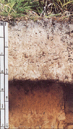
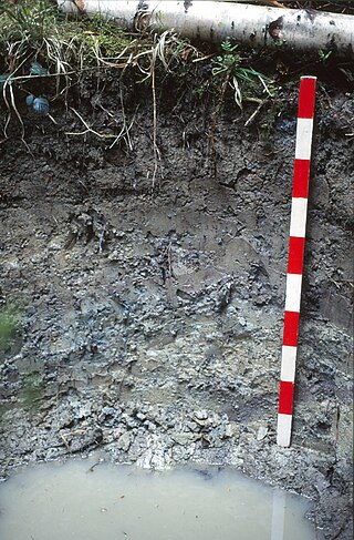
Bama (soil) soil type

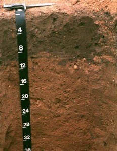
Bama is the official state soil of Alabama.

Antigo (soil) type of soil

Antigo soils are among the most extensive soils in Wisconsin. They occur on about 300,000 acres (1,200 km²) in the northern part of the State. Antigo soils are well-drained and formed under northern hardwood forests in loess and loamy sediments over stratified sandy outwash. The average annual precipitation ranges from 28 to 33 inches, and the average annual air temperature ranges from 39 to 45 °F. The soil series was named after the city of Antigo, Wisconsin.

Myakka (soil) Soil type

Myakka soil is the official state soil of Florida, which has more than 1,500,000 acres (6,100 km2) of land composed partly or entirely of Myakka soils. Its name derives from a Native American word that means "Big Waters". This soil is primarily located in broad flatwoods in irregularly shaped areas ranging from 5 to 500 acres in size. The organic matter content and fertility of the soil is low. Most areas where this soil occurs are native range or improved pasture, although some is used for citrus or vegetable farming. Some counties in Florida where this soil occurs are Hendry, Collier, Glades, and Lee.

Houdek (soil) type of soil, unique to South Dakota, USA

Houdek is a type of soil composed of glacial till and decomposed organic matter. The soil series was established in 1955 in Spink County, South Dakota. It is unique to the United States, but in particular to South Dakota where it is the state soil.

Atsbi Town in Tigray, Ethiopia

Atsbi is a town in Tigray, Ethiopia. Located in the Misraqawi (Eastern) Zone of the Tigray Region, about 50 kilometers northeast of Qwiha, this town has a latitude and longitude of 13°52′N39°44′E with an elevation of 2630 meters above sea level. It is the administrative center of Atsbi Wenberta woreda.

Kankakee Outwash Plain

The Kankakee Outwash Plain is a flat plain interspersed with sand dunes in the Kankakee River valley in northwestern Indiana and northeastern Illinois of the United States. It is just south of the Valparaiso Moraine and was formed during the Wisconsin Glaciation. As the glacier, stopped at the Valparaiso Moraine, melted, the meltwater was carried away to the outwash plain. On the south side of the moraine, where the elevation drops, the meltwaters eroded away valleys, carrying sand and mud with them. As the muddy meltwater reached the valley where the slope lessened, the water slowed down, depositing the sand on the outwash plain. This created a smooth, flat, and sandy plain. Before its draining, the Kankakee Marsh, located on the outwash plain, was one of the largest freshwater marshes in the United States.

Menfro soil type

Menfro soil is a series of deep, well drained, moderately permeable soils formed in 6-to-20-foot thick loess deposits. It is found in central and eastern Missouri and west-central and southwestern Illinois on upland ridgetops, backslopes, and benches adjacent to the Missouri and Mississippi rivers and their major tributaries. Menfro soils are prime farmland where the slope is less than 6 percent.

Stagnosol

A Stagnosol in the World Reference Base for Soil Resources (WRB) is soil with strong mottling of the soil profile due to redox processes caused by stagnating surface water.

Freweyni Place in Tigray, Ethiopia

Freweyni is a town in northern Ethiopia. Located 80 kilometers north of Mekele in the Misraqawi Zone of the Tigray Region of Ethiopia, this town has a latitude and longitude of 14°3′N39°34′E with an elevation of 2480 meters above sea level and is located along Ethiopian Highway 2.

Lake Kankakee

Lake Kankakee formed 14,000 years before present (YBP) in the valley of the Kankakee River. It developed from the outwash of the Michigan Lobe, Saginaw Lobe, and the Huron-Erie Lobe of the Wisconsin glaciation. These three ice sheets formed a basin across Northwestern Indiana. It was a time when the glaciers were receding, but had stopped for a thousand years in these locations. The lake drained about 13,000 YBP, until reaching the level of the Momence Ledge. The outcropping of limestone created an artificial base level, holding water throughout the upper basin, creating the Grand Kankakee Marsh.

Soil in Kilte Awulailo

The soils of the Kilte Awula’ilo woreda (district) in Tigray reflect its longstanding agricultural history, highly seasonal rainfall regime, relatively low temperatures, the presence of a wide depression at the foot of the Atsbi horst and steep slopes. Outstanding features in the soilscape are the wide ancient fluvial deposits, the soils of the granite batholith, cuestas and fertile lands behind tufa dams.

Soil in Atsbi Wenberta

The soils of the Atsbi Wenberta woreda (district) in Tigray (Ethiopia) reflect its longstanding agricultural history, highly seasonal rainfall regime and relatively low temperatures. The northern part of the district is on the high uplifted Atsbi Horst, whereas the southern part is dominated by the Des’a forest on Antalo Limestone. In between there is the fluvial landscape of Hayqi Meshal. Particularities in the southern part of the district are soil catenas on intervening plains behind tufa dams and in a polje.

Soil in Saisi Tsaida Imba

The soils of the Sa'isi Tsa'ida Imba woreda (district) in Tigray (Ethiopia) reflect its longstanding agricultural history, highly seasonal rainfall regime, relatively low temperatures, overall dominance of metamorphic and sandstone lithology and steep slopes.

The soils of the Inderta woreda (district) in Tigray (Ethiopia) reflect its longstanding agricultural history, highly seasonal rainfall regime, relatively low temperatures, overall dominance of limestone and dolerite lithologies and steep slopes. Outstanding features in the soilscape are wide plains with Vertisols.

Soil in Tanqwa Abergele

The soils of the Tanqwa Abergele woreda (district) in Tigray (Ethiopia) reflect its longstanding agricultural history, highly seasonal rainfall regime, relatively high temperatures, overall dominance of Precambrian metamorphic rocks and steep slopes.

Soil in Dogua Tembien

The soils of the Dogu’a Tembien woreda (district) in Tigray (Ethiopia) reflect its longstanding agricultural history, highly seasonal rainfall regime, relatively low temperatures, an extremely great variety in lithology and steep slopes. Outstanding features in the soilscape are the fertile highland Vertisols and Phaeozems in forests.

Crider (soil)

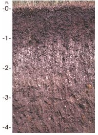
Crider is a soil series and the state soil of Kentucky.

References

  1. "Miami Indiana State Soil" (PDF). USDA - Natural Resources Conservation Service . Retrieved 2006-07-02.[ permanent dead link ]
  2. "Official series description - Miami". USDA - Natural Resources Conservation Service. Archived from the original on 2007-12-07. Retrieved 2006-07-02.