Soil science is the study of soil as a natural resource on the surface of the Earth including soil formation, classification and mapping; physical, chemical, biological, and fertility properties of soils; and these properties in relation to the use and management of soils.
Ecological classification or ecological typology is the classification of land or water into geographical units that represent variation in one or more ecological features. Traditional approaches focus on geology, topography, biogeography, soils, vegetation, climate conditions, living species, habitats, water resources, and sometimes also anthropic factors. Most approaches pursue the cartographical delineation or regionalisation of distinct areas for mapping and planning.
The Food and Agriculture Organization of the United Nations (FAO) developed a supra-national classification, which offers useful generalizations about pedogenesis in relation to the interactions between the main soil-forming factors. It was first published in form of the UNESCO Soil Map of the World (1974). Many of the names offered in that classification are known in many countries and do have similar meanings.
A soil type is a taxonomic unit in soil science. All soils that share a certain set of well-defined properties form a distinctive soil type. Soil type is a technical term of soil classification, the science that deals with the systematic categorization of soils. Every soil of the world belongs to a certain soil type. Soil type is an abstract term. In nature, you will not find soil types. You will find soils that belong to a certain soil type.
USDA soil taxonomy (ST) developed by the United States Department of Agriculture and the National Cooperative Soil Survey provides an elaborate classification of soil types according to several parameters and in several levels: Order, Suborder, Great Group, Subgroup, Family, and Series. The classification was originally developed by Guy Donald Smith, former director of the U.S. Department of Agriculture's soil survey investigations.

Soil classification deals with the systematic categorization of soils based on distinguishing characteristics as well as criteria that dictate choices in use.
Soil survey, soil mapping, is the process of classifying soil types and other soil properties in a given area and geo-encoding such information. It applies the principles of soil science, and draws heavily from geomorphology, theories of soil formation, physical geography, and analysis of vegetation and land use patterns. Primary data for the soil survey are acquired by field sampling and by remote sensing. Remote sensing principally uses aerial photography, but LiDAR and other digital techniques are steadily gaining in popularity. In the past, a soil scientist would take hard-copies of aerial photography, topo-sheets, and mapping keys into the field with them. Today, a growing number of soil scientists bring a ruggedized tablet computer and GPS into the field with them. The tablet may be loaded with digital aerial photos, LiDAR, topography, soil geodatabases, mapping keys, and more.
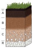
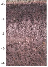
A soil horizon is a layer parallel to the soil surface whose physical, chemical and biological characteristics differ from the layers above and beneath. Horizons are defined in many cases by obvious physical features, mainly colour and texture. These may be described both in absolute terms and in terms relative to the surrounding material, i.e. 'coarser' or 'sandier' than the horizons above and below.
In USDA soil taxonomy, a Psamment is defined as an Entisol which consists basically of unconsolidated sand deposits, often found in shifting sand dunes but also in areas of very coarse-textured parent material subject to millions of years of weathering. This latter case is characteristic of the Guiana Highlands of northern South America. A Psamment has no distinct soil horizons, and must consist entirely of material of loamy sand or coarser in texture. In the World Reference Base for Soil Resources (WRB), Psamments are known as Arenosols.

Paleopedology is the discipline that studies soils of past geological eras, from quite recent (Quaternary) to the earliest periods of the Earth's history. Paleopedology can be seen either as a branch of soil science (pedology) or of paleontology, since the methods it uses are in many ways a well-defined combination of the two disciplines.
Soil texture is a classification instrument used both in the field and laboratory to determine soil classes based on their physical texture. Soil texture can be determined using qualitative methods such as texture by feel, and quantitative methods such as the hydrometer method based on Stokes' law. Soil texture has agricultural applications such as determining crop suitability and to predict the response of the soil to environmental and management conditions such as drought or calcium (lime) requirements. Soil texture focuses on the particles that are less than two millimeters in diameter which include sand, silt, and clay. The USDA soil taxonomy and WRB soil classification systems use 12 textural classes whereas the UK-ADAS system uses 11. These classifications are based on the percentages of sand, silt, and clay in the soil.
Soil morphology is the study of the formation and description of soil types within various soil horizons. C.F. Marbut championed reliance on soil morphology instead of on theories of pedogenesis for soil classification because theories of soil genesis are both ephemeral and dynamic.

The National Cooperative Soil Survey Program (NCSS) in the United States is a nationwide partnership of federal, regional, state, and local agencies and institutions. This partnership works together to cooperatively investigate, inventory, document, classify, and interpret soils and to disseminate, publish, and promote the use of information about the soils of the United States and its trust territories. The activities of the NCSS are carried out on national, regional, and state levels.

San Joaquin is an officially designated state insignia, the state soil of the U.S. state of California.
The Canadian System of Soil Classification is more closely related to the American system than any other, but they differ in several ways. The Canadian system is designed to cover only Canadian soils. The Canadian system dispenses with the sub-order hierarchical level. Solonetzic and Gleysolic soils are differentiated at the order level.
The early concepts of soil were based on ideas developed by a German chemist, Justus von Liebig (1803–1873), and modified and refined by agricultural scientists who worked on samples of soil in laboratories, greenhouses, and on small field plots. The soils were rarely examined below the depth of normal tillage. These chemists held the "balance-sheet" theory of plant nutrition. Soil was considered a more or less static storage bin for plant nutrients—the soils could be used and replaced. This concept still has value when applied within the framework of modern soil science, although a useful understanding of soils goes beyond the removal of nutrients from soil by harvested crops and their return in manure, lime, and fertilizer.

Subaqueous soils are soils formed in sediment found in shallow, permanently flooded environments or soils in any areas permanently covered by water too deep for the growth of rooted plants.
Houdek is a type of soil composed of glacial till and decomposed organic matter. The soil series was established in 1955 in Spink County, South Dakota. It is unique to the United States, but in particular to South Dakota where it is the state soil.
Roy W. Simonson was a scientist, professor, and writer who studied soil across the United States and on islands in the Western Pacific. He taught at Iowa State College from 1938 to 1943 and then became a Soil Correlator for the United States Department of Agriculture Division of Soil Survey. After World War II, Simonson worked for the Military Geology Unit to map soils on islands in the Western Pacific. Simonson spent the rest of his career at the Division of Soil Survey until his retirement in 1973. In his retirement, he occasionally taught courses on soil genesis as a visiting professor at the University of Maryland until relocating to Oberlin, Ohio, in 1993.