Related Research Articles
Soil retrogression and degradation are two regressive evolution processes associated with the loss of equilibrium of a stable soil. Retrogression is primarily due to soil erosion and corresponds to a phenomenon where succession reverts the land to its natural physical state. Degradation is an evolution, different from natural evolution, related to the local climate and vegetation. It is due to the replacement of primary plant communities by the secondary communities. This replacement modifies the humus composition and amount, and affects the formation of the soil. It is directly related to human activity. Soil degradation may also be viewed as any change or ecological disturbance to the soil perceived to be deleterious or undesirable.

Prairies are ecosystems considered part of the temperate grasslands, savannas, and shrublands biome by ecologists, based on similar temperate climates, moderate rainfall, and a composition of grasses, herbs, and shrubs, rather than trees, as the dominant vegetation type. Temperate grassland regions include the Pampas of Argentina, Brazil and Uruguay, and the steppe of Ukraine, Russia and Kazakhstan. Lands typically referred to as "prairie" tend to be in North America. The term encompasses the area referred to as the Interior Lowlands of Canada, the United States, and Mexico, which includes all of the Great Plains as well as the wetter, hillier land to the east.

A wetland is a distinct ecosystem that is flooded by water, either permanently or seasonally. Flooding results in oxygen-free (anoxic) processes prevailing, especially in the soils. The primary factor that distinguishes wetlands from terrestrial land forms or water bodies is the characteristic vegetation of aquatic plants, adapted to the unique anoxic hydric soils. Wetlands are considered among the most biologically diverse of all ecosystems, serving as home to a wide range of plant and animal species. Methods for assessing wetland functions, wetland ecological health, and general wetland condition have been developed for many regions of the world. These methods have contributed to wetland conservation partly by raising public awareness of the functions some wetlands provide.
Pedogenesis is the process of soil formation as regulated by the effects of place, environment, and history. Biogeochemical processes act to both create and destroy order (anisotropy) within soils. These alterations lead to the development of layers, termed soil horizons, distinguished by differences in color, structure, texture, and chemistry. These features occur in patterns of soil type distribution, forming in response to differences in soil forming factors.

For the ship anchorage, see The Downs.
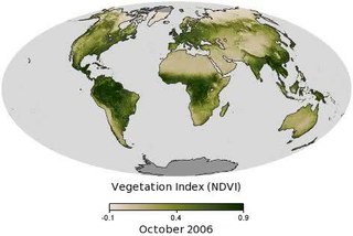
Vegetation is an assemblage of plant species and the ground cover they provide. It is a general term, without specific reference to particular taxa, life forms, structure, spatial extent, or any other specific botanical or geographic characteristics. It is broader than the term flora which refers to species composition. Perhaps the closest synonym is plant community, but vegetation can, and often does, refer to a wider range of spatial scales than that term does, including scales as large as the global. Primeval redwood forests, coastal mangrove stands, sphagnum bogs, desert soil crusts, roadside weed patches, wheat fields, cultivated gardens and lawns; all are encompassed by the term vegetation.

In geography and geology, fluvial processes are associated with rivers and streams and the deposits and landforms created by them. When the stream or rivers are associated with glaciers, ice sheets, or ice caps, the term glaciofluvial or fluvioglacial is used.

In the geosciences, paleosol can have two meanings, the first from geology and paleontology, and the second from soil science. In soil-science the term refers to any ancient, buried soil that is anomalous in its context; in geology and paleontology it specifically refers to soils buried under volcanic rock.
Rendzina is a soil type recognized in various soil classification systems, including those of Britain and Germany as well as some obsolete systems. They are humus-rich shallow soils that are usually formed from carbonate- or occasionally sulfate-rich parent material. Rendzina soils are often found in karst and mountainous regions.

Pawnee National Grassland is a United States National Grassland located in northeastern Colorado on the Colorado Eastern Plains. The grassland is located in the South Platte River basin in remote northern and extreme northeastern Weld County between Greeley and Sterling. It comprises two parcels totaling 193,060 acres (78,130 ha) largely between State Highway 14 and the Wyoming border. The larger eastern parcel lies adjacent to the borders of both Nebraska and Wyoming. It is administered in conjunction with the Arapaho-Roosevelt National Forest from the U.S. Forest Service office in Fort Collins, with a local ranger district office in Greeley.

Paleopedology is the discipline that studies soils of past geological eras, from quite recent (Quaternary) to the earliest periods of the Earth's history. Paleopedology can be seen either as a branch of soil science (pedology) or of paleontology, since the methods it uses are in many ways a well-defined combination of the two disciplines.
Soil morphology is the study of the formation and description of soil types within various soil horizons. C.F. Marbut championed reliance on soil morphology instead of on theories of pedogenesis for soil classification because theories of soil genesis are both ephemeral and dynamic.
The Canadian System of Soil Classification is more closely related to the American system than any other, but they differ in several ways. The Canadian system is designed to cover only Canadian soils. The Canadian system dispenses with the sub-order hierarchical level. Solonetzic and Gleysolic soils are differentiated at the order level.
There have been known various classifications of landslides. Broad definitions include forms of mass movement that narrower definitions exclude. For example, the McGraw-Hill Encyclopedia of Science and Technology distinguishes the following types of landslides:
Channel patterns are found in rivers, streams, and other bodies of water that transport water from one place to another. Systems of branching river channels dissect most of the sub-aerial landscape, each in a valley proportioned to its size. Whether formed by chance or necessity, by headward erosion or downslope convergence, whether inherited or newly formed. Depending on different geological factors such as weathering, erosion, depositional environment, and sediment type, different types of channel patterns can form.

Salt pannes and pools are water retaining depressions located within salt and brackish marshes. Pools tend to retain water during the summer months between high tides, whereas pannes generally do not. Salt pannes generally start when a mat of organic debris is deposited upon existing vegetation, killing it. This creates a slight depression in the surrounding vegetation which retains water for varying periods of time. Upon successive cycles of inundation and evaporation the panne develops an increased salinity greater than that of the larger body of water. This increased salinity dictates the type of flora and fauna able to grow within the panne. Salt pools are also secondary formations, though the exact mechanism(s) of formation are not well understood; some have predicted they will increase in size and abundance in the future due to rising sea levels.

River bank failure can be caused when the gravitational forces acting on a bank exceed the forces which hold the sediment together. Failure depends on sediment type, layering, and moisture content.
There are seven soil deposits in India. They are alluvial soil, black soil, red soil, laterite soil, or arid soil, and forest and mountainous soil,marsh soil. These soils are formed by the sediments brought down by the rivers. They also have varied chemical properties. Sundarbans mangrove swamps are rich in Marsh soil.
Vegetation classification is the process of classifying and mapping the vegetation over an area of the earth's surface. Vegetation classification is often performed by state based agencies as part of land use, resource and environmental management. Many different methods of vegetation classification have been used. In general, there has been a shift from structural classification used by forestry for the mapping of timber resources, to floristic community mapping for biodiversity management. Whereas older forestry-based schemes considered factors such as height, species and density of the woody canopy, floristic community mapping shifts the emphasis onto ecological factors such as climate, soil type and floristic associations. Classification mapping is usually now done using geographic information systems (GIS) software.

The Mississippi Alluvial Plain is a Level III ecoregion designated by the Environmental Protection Agency (EPA) in seven U.S. states, though predominantly in Arkansas, Louisiana, and Mississippi. It parallels the Mississippi River from the Midwestern United States to the Gulf of Mexico.
References
- Baldwin, M.; C.E. Kellogg; J. Thorp (1938). "Soil Classification". Soils and Men: Yearbook of Agriculture 1938. U.S. Government Printing Office, Washington, D.C. pp. 979–1001.
- Brevik, Eric C. (November 2002). "Soil Classification in Geology Textbooks" (PDF). Journal of Geoscience Education. 50 (5): 539–543. doi:10.5408/1089-9995-50.5.539 . Retrieved 2006-04-06.