
Baconton is a city in Mitchell County, Georgia, United States. As of the 2020 census, the city had a population of 856, down from 915 in 2010.
Dry–mesic prairie is a native grassland community made up mid-to-tall grasses and a diverse mixture of forbs. The sandy loam or loamy sand soils of Dry-mesic Prairie support grasses that are shorter and grow less densely than Wet-mesic and Wet Prairies. Big bluestem, little bluestem, Indian grass, and porcupine grass are the most abundant grasses in dry-mesic prairie.
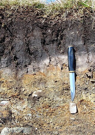
In soil science, podzols, also known as podosols, spodosols, or espodossolos, are the typical soils of coniferous or boreal forests and also the typical soils of eucalypt forests and heathlands in southern Australia. In Western Europe, podzols develop on heathland, which is often a construct of human interference through grazing and burning. In some British moorlands with podzolic soils, cambisols are preserved under Bronze Age barrows.
This is an index of articles relating to soil.
Kalkaska sand is the official soil of the U.S. state of Michigan.
The Piedmont region of Virginia is a part of the greater Piedmont physiographic region which stretches from the falls of the Potomac, Rappahannock, and James Rivers to the Blue Ridge Mountains. The region runs across the middle of the state from north to south, expanding outward to a width of nearly 190 miles at the border with North Carolina. To the north, the region continues from Virginia into central Maryland and southeastern Pennsylvania.
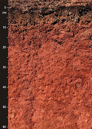
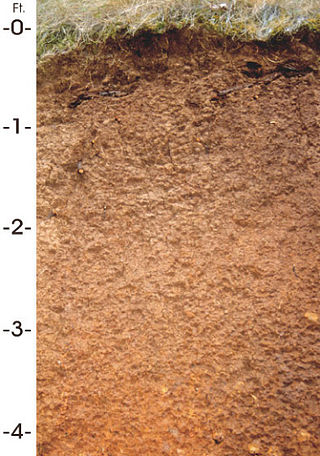
Originally mapped in Cecil County, Maryland in 1899, more than 10 million acres (40,000 km2) of the Cecil soil series are now mapped in the Piedmont region of the southeastern United States. It extends from Virginia through North Carolina, South Carolina, Georgia and Alabama, with the typic Cecil pedon actually located in Franklin County, NC.
Soil texture is a classification instrument used both in the field and laboratory to determine soil classes based on their physical texture. Soil texture can be determined using qualitative methods such as texture by feel, and quantitative methods such as the hydrometer method based on Stokes' law. Soil texture has agricultural applications such as determining crop suitability and to predict the response of the soil to environmental and management conditions such as drought or calcium (lime) requirements. Soil texture focuses on the particles that are less than two millimeters in diameter which include sand, silt, and clay. The USDA soil taxonomy and WRB soil classification systems use 12 textural classes whereas the UK-ADAS system uses 11. These classifications are based on the percentages of sand, silt, and clay in the soil.
Orovada series soil is the official state soil of Nevada. The soil series has an extent of 367,853 acres (148,865 ha), primarily in northern and central Nevada, and extending into southern Idaho and Oregon. They are common soils on semiarid rangeland with sagebrush-grassland plant communities. Orovada soils are arable, able to be cultivated, when irrigated and are considered prime farmland. Alfalfa for hay and seed, winter wheat, barley, and grasses for hay and pasture are the principal crops grown on these soils.

San Joaquin is an officially designated state insignia, the state soil of the U.S. state of California.

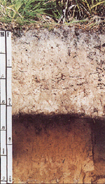
Antigo soils are among the most extensive soils in Wisconsin. They occur on about 300,000 acres (1,200 km²) in the northern part of the State. Antigo soils are well-drained and formed under northern hardwood forests in loess and loamy sediments over stratified sandy outwash. The average annual precipitation ranges from 28 to 33 inches, and the average annual air temperature ranges from 39 to 45 °F. The soil series was named after the city of Antigo, Wisconsin.
Tifton soil is the official state soil of the state of Georgia.
Myakka soil is the official state soil of Florida, which has more than 1,500,000 acres (6,100 km2) of land composed partly or entirely of Myakka soils, out of its total acreage of 42,084,928 acres (170,311.66 km2). This soil is primarily located in broad flatwoods in irregularly shaped areas ranging from 5 to 500 acres in size. The organic matter content and fertility of the soil is low. Most areas where this soil occurs are native range or improved pasture, although some is used for citrus or vegetable farming. Some counties in Florida where this soil occurs are Hendry, Collier, Glades, and Lee.

A petrocalcic horizon is a diagnostic horizon in the USDA soil taxonomy (ST) and in the World Reference Base for Soil Resources (WRB). They are formed when secondary calcium carbonate or other carbonates accumulate in the subsoil to the extent that the soil becomes cemented into a hardpan. Petrocalcic horizons are similar to a duripan and a petrogypsic horizon (WRB) in how they affect land-use limitations. They can occur in conjunction with duripans where the conditions are right and there are enough free carbonates in the soil. Calcium carbonates are found in alkaline soils, which are typical of arid and semiarid climates. A common field test for the presence of carbonates is application of hydrochloric acid to the soil, which indicates by fizzing and bubbling the presence of calcium carbonates.
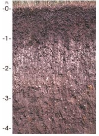
Houdek is a type of soil composed of glacial till and decomposed organic matter. The soil series was established in 1955 in Spink County, South Dakota. It is unique to the United States, but in particular to South Dakota where it is the state soil.
In 1988, the Professional Soil Classifiers Association of Mississippi selected Natchez silt loam soil to represent the soil resources of the State. These soils exist on 171,559 acres (69,427 ha) of landscape in Mississippi.
The Jory series consists of very deep, well-drained soils that formed in colluvium derived from basic igneous rock. These soils are in the foothills surrounding the Willamette Valley of the United States. They have been mapped on more than 300,000 acres (1,200 km2) in western Oregon. They are named after Jory Hill, Marion County, Oregon, which itself is named for the Jory family, who settled in the area in 1852 after traveling along the Oregon Trail.
The Olympic soil series is a type of deep, dark reddish brown, moderately fine-textured soil that has developed on mafic rock such as basalt. The series covers large areas in southwestern Washington and western Oregon, and usually supports forests of Douglas-fir, red alder, western redcedar, western hemlock, and bigleaf maple.
Mount Scott Conservation Park is a protected area in the Australian state of South Australia located in the gazetted locality of Blackford about 23 kilometres (14 mi) east of Kingston SE in the state's Limestone Coast region.
The Sassafras soil series is one of the oldest in the United States and has great historical significance to modern-day soil science. It was recognized as Maryland's state soil in 1901 and is now identified as a Benchmark and Hall of Fame soil series, which is a recognition given to a soil series for having a critical role in the evolution of soil science. It has been mapped in over 500,000 acres around Maryland and is also found in Pennsylvania, New Jersey, Delaware, Virginia, and Washington DC.
