| Profile of Crider soil | |
|---|---|
 |
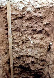
Crider is a soil series [1] [2] and the state soil of Kentucky. [3] [4] [5] [6] [7] [8]
| Profile of Crider soil | |
|---|---|
| |
Crider is a soil series [1] [2] and the state soil of Kentucky. [3] [4] [5] [6] [7] [8]
The Natural Resources Conservation Service describes Crider as a soil series with "very deep, well drained, moderately permeable soils on uplands. They formed in a mantle of loess and the underlying limestone residuum." [1] [6] It is known to be present in Kentucky, Indiana, Illinois, Missouri, Ohio, and Tennessee. [1] The soil is a considered highly productive agricultural soil, such that much of Kentucky's land with Crider soil is used for farming. [1] [5] [6]
In 1990, Crider was named the state soil of Kentucky. [7] [5] [6] It is present in 35 counties in the state, most extensively in the Pennyroyal Plateau. [7]

Natural resources are resources that are drawn from nature and used with few modifications. This includes the sources of valued characteristics such as commercial and industrial use, aesthetic value, scientific interest, and cultural value. On Earth, it includes sunlight, atmosphere, water, land, all minerals along with all vegetation, and wildlife.

A swamp is a forested wetland. Swamps are considered to be transition zones because both land and water play a role in creating this environment. Swamps vary in size and are located all around the world. The water of a swamp may be fresh water, brackish water, or seawater. Freshwater swamps form along large rivers or lakes where they are critically dependent upon rainwater and seasonal flooding to maintain natural water level fluctuations. Saltwater swamps are found along tropical and subtropical coastlines. Some swamps have hammocks, or dry-land protrusions, covered by aquatic vegetation, or vegetation that tolerates periodic inundation or soil saturation. The two main types of swamp are "true" or swamp forests and "transitional" or shrub swamps. In the boreal regions of Canada, the word swamp is colloquially used for what is more formally termed a bog, fen, or muskeg. Some of the world's largest swamps are found along major rivers such as the Amazon, the Mississippi, and the Congo.
A sapric is a subtype of a histosol where virtually all of the organic material has undergone sufficient decomposition to prevent the identification of plant parts. Muck is a sapric soil that is naturally waterlogged or is artificially drained.

The Little Miami River is a Class I tributary of the Ohio River that flows 111 miles (179 km) through five counties in southwestern Ohio in the United States. The Little Miami joins the Ohio River east of Cincinnati. It forms parts of the borders between Hamilton and Clermont counties and between Hamilton and Warren counties. The Little Miami River is one of 156 American rivers designated by the U.S. Congress or the Secretary of the Interior as a National Wild and Scenic River and lends its name to the adjacent Little Miami Scenic Trail.
Natural Resources Conservation Service (NRCS), formerly known as the Soil Conservation Service (SCS), is an agency of the United States Department of Agriculture (USDA) that provides technical assistance to farmers and other private landowners and managers.

The Driftless Area, a topographical and cultural region in the Midwestern United States, comprises southwestern Wisconsin, southeastern Minnesota, northeastern Iowa, and the extreme northwestern corner of Illinois.

Lost Maples State Natural Area is a 2,906-acre (1,176 ha) area of hills and canyons on the upper Sabinal River in the Edwards Plateau Region of Texas. It is designated a Natural Area, rather than a State Park, which means the primary focus is the maintenance and protection of the property's natural state. Accordingly, access and recreational activities may be restricted if the Texas Parks & Wildlife Department (TPWD) deems such action necessary to protect the environment.
Kalkaska sand is the official soil of the U.S. state of Michigan.

The National Cooperative Soil Survey Program (NCSS) in the United States is a nationwide partnership of federal, regional, state, and local agencies and institutions. This partnership works together to cooperatively investigate, inventory, document, classify, and interpret soils and to disseminate, publish, and promote the use of information about the soils of the United States and its trust territories. The activities of the NCSS are carried out on national, regional, and state levels.

The Miami soil series is the state soil of Indiana.
Downer is the New Jersey state soil. The Downer has four soil horizons:
The Illinois Department of Natural Resources (IDNR) is the code department of the Illinois state government that operates the state parks and state recreation areas, enforces the fishing and game laws of Illinois, regulates Illinois coal mines, operates the Illinois State Museum system, and oversees scientific research into the soil, water, and mineral resources of the state. In 2017, the Illinois Historic Preservation Division was added to its portfolio. It is headquartered in the state capital of Springfield.

Bama is the official state soil of Alabama.

Antigo soils are among the most extensive soils in Wisconsin. They occur on about 300,000 acres (1,200 km²) in the northern part of the State. Antigo soils are well-drained and formed under northern hardwood forests in loess and loamy sediments over stratified sandy outwash. The average annual precipitation ranges from 28 to 33 inches, and the average annual air temperature ranges from 39 to 45 °F. The soil series was named after the city of Antigo, Wisconsin.
Houston black soil extends over 1,500,000 acres (6,100 km2) of the Texas blackland prairies and is the Texas state soil. The series is composed of expansive clays and is considered one of the classic vertisols.
Menfro soil is a series of deep, well drained, moderately permeable soils formed in 6-to-20-foot thick loess deposits. It is found in central and eastern Missouri and west-central and southwestern Illinois on upland ridgetops, backslopes, and benches adjacent to the Missouri and Mississippi rivers and their major tributaries. Menfro soils are prime farmland where the slope is less than 6 percent.

The Wittenberg University Speleological Society (WUSS) is a student-run grotto of the National Speleological Society (NSS) created in 1980, dedicated to the advancement of speleology. WUSS has more than 500 members, current and past students, faculty and staff of Wittenberg University, as well as community members dedicated to the scientific study, exploration, and preservation of caves and karst environments. The organization is based out of Wittenberg University in Springfield, Ohio.
The International Year of Soils, 2015 was declared by the Sixty-eighth session of the United Nations General Assembly on December 20, 2013, after recognizing December 5 as World Soil Day.

Michael R. Crider is an Indiana politician who has represented District 28 of the Indiana Senate since 2012, currently serving as the Majority Whip. He previously served as Director of Law Enforcement for the Indiana Department of Natural Resources from 2006 to 2010. Crider ran for the Republican nomination for Indiana's 6th congressional district in 2018, but he dropped out in December 2017.