| Holdrege | |
|---|---|
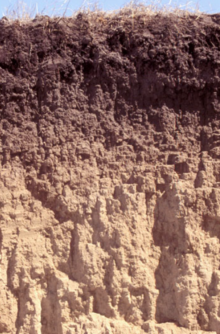 Holdrege soil | |
| Argiustoll |
The Holdrege silt loam is the state soil of Nebraska since 1979.
| Holdrege | |
|---|---|
| Holdrege soil | |
| Argiustoll |
The Holdrege silt loam is the state soil of Nebraska since 1979.
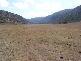
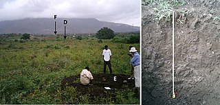
In soil taxonomy, its full description is a "Holdrege silt loam, fine-silty, mixed, mesic, Typic Argiustoll". [1] Holdrege silt loam covers 1.8 million acres of land in south-central Nebraska, under a grass landscape. Good drainage and moisture movement resulted in the downward movement of clay and lime. First described in 1917 in Phelps County, Nebraska, the soil has a significant role in corn, grain and soy farming. Formed in silty, calcareous loess, the soil ranges from 0 to 15 percent slope. [2] [3]

Chase County is a county in the U.S. state of Nebraska. As of the 2020 United States Census, the population was 3,893. Its county seat is Imperial.

Mount Arvon at 1,979 feet (603 m), is the highest natural point in the U.S. state of Michigan. Located in L'Anse Township, Baraga County, Mount Arvon is part of the Huron Mountains. It rises about eight miles (13 km) south of Lake Superior. On the list of highest natural points in each U.S. state, Mount Arvon ranks 38th. It is the highest natural point in the East North Central states.

Loam is soil composed mostly of sand, silt, and a smaller amount of clay. By weight, its mineral composition is about 40–40–20% concentration of sand–silt–clay, respectively. These proportions can vary to a degree, however, and result in different types of loam soils: sandy loam, silty loam, clay loam, sandy clay loam, silty clay loam, and loam.
This is an index of articles relating to soil.
Stuttgart soil series is an officially designated state symbol, the State Soil of Arkansas.

Charles Mound is a gentle, 1,235-foot (376 m) high hill located in Scales Mound Township, Jo Daviess County, Illinois, United States. It is 2 miles (3.2 km) northeast of the small town of Scales Mound, and 11 miles (18 km) northeast of Galena. Despite its name, Charles Mound is a naturally occurring, erosional feature and is not to be confused with the intentional mounds created by native cultures. It is the highest natural point in the state and is thus considered a state highpoint. It is the lowest state highpoint in the Midwestern region of the United States.
Soil texture is a classification instrument used both in the field and laboratory to determine soil classes based on their physical texture. Soil texture can be determined using qualitative methods such as texture by feel, and quantitative methods such as the hydrometer method based on Stokes' law. Soil texture has agricultural applications such as determining crop suitability and to predict the response of the soil to environmental and management conditions such as drought or calcium (lime) requirements. Soil texture focuses on the particles that are less than two millimeters in diameter which include sand, silt, and clay. The USDA soil taxonomy and WRB soil classification systems use 12 textural classes whereas the UK-ADAS system uses 11. These classifications are based on the percentages of sand, silt, and clay in the soil.

Aster alpinus, the alpine aster or blue alpine daisy, is a species of flowering plant in the family Asteraceae, native to the mountains of Europe, with a subspecies native to Canada and the United States. This herbaceous perennial has purple, pink, or blue flowers in summer.
Apple River Canyon State Park is an Illinois state park on 297 acres (120 ha) in Jo Daviess County, Illinois, United States. The park was begun with land purchased by the state in 1932, as a result of a prolonged campaign led by botanist Herman Silas Pepoon; with additional acquisitions since, 1,907 acres (772 ha) of land have been preserved to protect much of an 8+1⁄2-mile (13.7 km) long canyon on the Apple River.
In 1988, the Professional Soil Classifiers Association of Mississippi selected Natchez silt loam soil to represent the soil resources of the State. These soils exist on 171,559 acres of landscape in Mississippi.
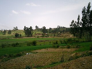
Atsbi is a town in Tigray, Ethiopia. Located in the Misraqawi (Eastern) Zone of the Tigray Region, about 50 kilometers northeast of Qwiha, this town has a latitude and longitude of 13°52′N39°44′E with an elevation of 2630 meters above sea level. It is the administrative center of Atsbi Wenberta woreda.
Mousetail Landing State Park is a 1,247-acre (5.05 km2) state park located on the eastern bank of the Tennessee River in Perry County, Tennessee near Linden. The park was established in 1979, making it one of the more recent additions to the Tennessee State Parks system. The name is thought to have been derived from an event during the American Civil War in which a tannery located at a river landing on the site of the present day state park caught fire. The tannery was infested with an unusually large number of mice which fled the burning tannery in the direction of the landing, giving the landing its present name.
Rudrasagar Lake, also known as Twijilikma, is a lake located in Melaghar, Tripura, India.
The Olympic soil series is a type of deep, dark reddish brown moderately fine-textured soil which has developed on mafic rock such as basalt. The series covers large areas in southwestern Washington and western Oregon, and usually supports forests of Douglas-fir, red alder, western redcedar, western hemlock, and bigleaf maple.

Lower Mesopotamia is a historical region of Mesopotamia. It's located in the alluvial plain of Iraq from the Hamrin Mountains to the Faw Peninsula near the Persian Gulf.

Francis Doan Hole, was an American pedologist, educator, and musician, best known for his contributions to mapping the extent of soils and their properties in the Wisconsin region and using inventive lectures and musical performances to communicate and popularize the field of soil science. His work and reputation earned him various titles of endearment in his community and among soil scientists worldwide, notably “Ambassador of Soils" and "Poet Laureate of Soil Science".

The soils of the Kilte Awula’ilo woreda (district) in Tigray, Ethiopia reflect its longstanding agricultural history, highly seasonal rainfall regime, relatively low temperatures, the presence of a wide depression at the foot of the Atsbi horst and steep slopes. Outstanding features in the soilscape are the wide ancient fluvial deposits, the soils of the granite batholith, cuestas and fertile lands behind tufa dams.
The soils of the Atsbi Wenberta woreda (district) in Tigray (Ethiopia) reflect its longstanding agricultural history, highly seasonal rainfall regime and relatively low temperatures. The northern part of the district is on the high uplifted Atsbi Horst, whereas the southern part is dominated by the Des’a forest on Antalo Limestone. In between there is the fluvial landscape of Hayqi Meshal. Particularities in the southern part of the district are soil catenas on intervening plains behind tufa dams and in a polje.
The soils of the Tanqwa Abergele woreda (district) in Tigray (Ethiopia) reflect its longstanding agricultural history, highly seasonal rainfall regime, relatively high temperatures, overall dominance of Precambrian metamorphic rocks and steep slopes.

The Western Corn Belt Plains is a Level III ecoregion designated by the Environmental Protection Agency (EPA) in seven U.S. states, though predominantly in Iowa.
| | This Nebraska-related article is a stub. You can help Wikipedia by expanding it. |