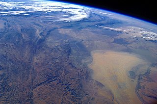
Turkmenistan is a landlocked country in Central Asia, bordering the Caspian Sea to the west, Iran and Afghanistan to the south, Uzbekistan to the north-east, and Kazakhstan to the north-west. It is the southernmost republic of the Commonwealth of Independent States (CIS), the loose federation created at the end of 1991 by most of the Post-Soviet states.

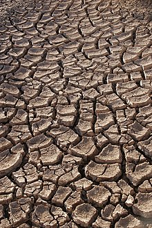
Soil salinity is the salt content in the soil; the process of increasing the salt content is known as salinization. Salts occur naturally within soils and water. Salination can be caused by natural processes such as mineral weathering or by the gradual withdrawal of an ocean. It can also come about through artificial processes such as irrigation and road salt.
Weathering is the deterioration of rocks, soils and minerals through contact with water, atmospheric gases, sunlight, and biological organisms. It occurs in situ, and so is distinct from erosion, which involves the transport of rocks and minerals by agents such as water, ice, snow, wind, waves and gravity.

Natural salt pans or salt flats are flat expanses of ground covered with salt and other minerals, usually shining white under the sun. They are found in deserts and are natural formations.

A dry lake bed, also known as a playa, is a basin or depression that formerly contained a standing surface water body, which disappears when evaporation processes exceed recharge. If the floor of a dry lake is covered by deposits of alkaline compounds, it is known as an alkali flat. If covered with salt, it is known as a salt flat.

Aeolian processes, also spelled eolian, pertain to wind activity in the study of geology and weather and specifically to the wind's ability to shape the surface of the Earth. Winds may erode, transport, and deposit materials and are effective agents in regions with sparse vegetation, a lack of soil moisture and a large supply of unconsolidated sediments. Although water is a much more powerful eroding force than wind, aeolian processes are important in arid environments such as deserts.
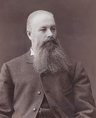
Vasily Vasilyevich Dokuchaev was a Russian geologist and geographer who is credited with laying the foundations of soil science. The Ukrainian city of Dokuchaievsk is named after him.

Biological soil crusts are communities of living organisms on the soil surface in arid and semi-arid ecosystems. They are found throughout the world with varying species composition and cover depending on topography, soil characteristics, climate, plant community, microhabitats, and disturbance regimes. Biological soil crusts perform important ecological roles including carbon fixation, nitrogen fixation and soil stabilization; they alter soil albedo and water relations and affect germination and nutrient levels in vascular plants. They can be damaged by fire, recreational activity, grazing and other disturbances and can require long time periods to recover composition and function. Biological soil crusts are also known as biocrusts or as cryptogamic, microbiotic, microphytic, or cryptobiotic soils.

Lake Abbe, also known as Lake Abhe Bad, is a salt lake, lying on the Ethiopia-Djibouti border. It is one of a chain of six connected lakes, which also includes lakes Gargori, Laitali, Gummare, Bario and Afambo. The lake is the ultimate destination of the Awash River, which is at the center of the Afar Triangle. Lake Abbe is considered one of the most inaccessible areas of the earth. The water itself is known for its flamingos.
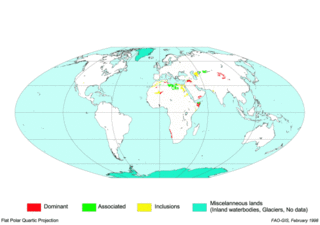
Gypsisols in the World Reference Base for Soil Resources (WRB) are soils with substantial secondary accumulation of gypsum (CaSO4.2H2O). They are found in the driest parts of the arid climate zone. In the USDA soil taxonomy they are classified as Gypsids (USDA Soil Taxonomy), in the Russian soil classification they are called Desert soils (USSR).

A desert pavement, also called reg, serir, gibber, or saï is a desert surface covered with closely packed, interlocking angular or rounded rock fragments of pebble and cobble size. They typically top alluvial fans. Desert varnish collects on the exposed surface rocks over time.

The Makgadikgadi Pan, a salt pan situated in the middle of the dry savanna of north-eastern Botswana, is one of the largest salt flats in the world. The pan is all that remains of the formerly enormous Lake Makgadikgadi, which once covered an area larger than Switzerland, but dried up tens of thousands of years ago. Recent studies of human mitochondrial DNA suggest that modern Homo sapiens first began to evolve in this region some 200,000 years ago, when it was a vast, exceptionally fertile area of lakes, rivers, marshes, woodlands and grasslands especially favorable for habitation by evolving hominins and other mammals.
Environmental issues in Tajikistan include concentrations of agricultural chemicals and salts in the soil and groundwater, poor management of water resources, and soil erosion. Additionally, because of inadequate sanitation facilities, untreated industrial waste and sewage combine with agricultural runoff to cause water pollution in the Aral Sea Basin. Soviet-Era mining operations in Tajikistan extracted and processed uranium, gold, antimony, tungsten, mercury, and molybdenum, each of which is known to leave toxic waste that also threatens water quality. Pockets of high air pollution caused by industry and motor vehicles have resulted in Tajikistan ranking 133rd in the world in greenhouse gas emissions. Air pollution is a particular problem during times of the year when atmospheric conditions hold industrial and vehicle emissions close to the surface in urban areas. In summer, dust and sand from the deserts of Uzbekistan and Turkmenistan cause air pollution across the entire southwestern lowland region.

An erg is a broad, flat area of desert covered with wind-swept sand with little or no vegetative cover. The word is derived from the Arabic word ʿirq (عرق), meaning "dune field". Strictly speaking, an erg is defined as a desert area that contains more than 125 km2 (48 sq mi) of aeolian or wind-blown sand and where sand covers more than 20% of the surface. Smaller areas are known as "dune fields". The largest hot desert in the world, the Sahara, covers 9 million square kilometres and contains several ergs, such as the Chech Erg and the Issaouane Erg in Algeria. Approximately 85% of all the Earth's mobile sand is found in ergs that are greater than 32,000 km2 (12,355 sq mi), the largest being the Rub' al Khali, the Empty Quarter of the Arabian Peninsula. Ergs are also found on other celestial bodies, such as Venus, Mars, and Saturn's moon Titan.

A sabkha is a coastal, supratidal mudflat or sandflat in which evaporite-saline minerals accumulate as the result of semiarid to arid climate. Sabkhas are gradational between land and intertidal zone within restricted coastal plains just above normal high-tide level. Within a sabkha, evaporite-saline minerals sediments typically accumulate below the surface of mudflats or sandflats. Evaporite-saline minerals, tidal-flood, and aeolian deposits characterize many sabkhas found along modern coastlines. The accepted type locality for a sabkha is at the southern coast of the Persian Gulf, in the United Arab Emirates. Evidence of clastic sabkhas are found in the geological record of many areas, including the UK and Ireland. Sabkha is a phonetic transliteration of the Arabic word used to describe any form of salt flat. A sabkha is also known as a sabkhah,sebkha, or coastal sabkha.

Tamarix aphylla is the largest known species of Tamarix, with heights up to 18 metres (59 ft). The species has a variety of common names, including Athel tamarisk, Athel tree, and Athel pine. It is an evergreen tree, native across North, East, and Central Africa, through the Middle East, and into parts of Western and Southern Asia.
A desert is a landscape where little precipitation occurs and, consequently, living conditions create unique biomes and ecosystems. The lack of vegetation exposes the unprotected surface of the ground to denudation. About one-third of the land surface of the Earth is arid or semi-arid. This includes much of the polar regions, where little precipitation occurs, and which are sometimes called polar deserts or "cold deserts". Deserts can be classified by the amount of precipitation that falls, by the temperature that prevails, by the causes of desertification or by their geographical location.

Innokenti Petrovich Gerasimov was a Soviet geographer and pedologist, professor, academician of the Soviet Academy of Sciences (1953). He was a creator of "constructive geography" – a new scientific direction, which was focused on the problems of conservation and using nature. According to him, constructive geography was formed in the era of the scientific and technological revolution, when geographical science had more complicated tasks, which should cover activity of many branches of the economy and change of many components of nature and society in the territory of very extensive and various regions.

Land, also known as dry land, ground, or earth, is the solid terrestrial surface of Earth not submerged by the ocean or another body of water. It makes up 29.2% of Earth's surface and includes all continents and islands. Earth's land surface is almost entirely covered by regolith, a layer of rock, soil, and minerals that forms the outer part of the crust. Land plays an important role in Earth's climate system, being involved in the carbon cycle, nitrogen cycle, and water cycle. One-third of land is covered in trees, another third is used for agriculture, and one-tenth is covered in permanent snow and glaciers. The remainder consists of desert, savannah, and prairie.

A sor is a closed drainless depression characteristic of the Central Asian deserts, found especially in Kazakhstan. The sor area is seasonally flooded, forming a lake, which becomes an inland salt marsh and then a salt flat as it dries.