
Salisbury Plain is a chalk plateau in the south western part of central southern England covering 300 square miles (780 km2). It is part of a system of chalk downlands throughout eastern and southern England formed by the rocks of the Chalk Group and largely lies within the county of Wiltshire, but stretches into Hampshire.

The Mendip Hills is a range of limestone hills to the south of Bristol and Bath in Somerset, England. Running from Weston-super-Mare and the Bristol Channel in the west to the Frome valley in the east, the hills overlook the Somerset Levels to the south and the Chew Valley and other tributaries of the Avon to the north. The hills give their name to the local government district of Mendip, which administers most of the area. The higher, western part of the hills, covering 198 km2 (76 sq mi) has been designated an Area of Outstanding Natural Beauty (AONB), which gives it a level of protection comparable to a national park.

The North Downs are a ridge of chalk hills in south east England that stretch from Farnham in Surrey to the White Cliffs of Dover in Kent. Much of the North Downs comprises two Areas of Outstanding Natural Beauty (AONBs): the Surrey Hills and the Kent Downs. The North Downs Way National Trail runs along the North Downs from Farnham to Dover.

The greater horseshoe bat is an insectivorous bat of the genus Rhinolophus. Its distribution covers Europe, Northern Africa, Central Asia and Eastern Asia. It is the largest of the horseshoe bats in Europe and is thus easily distinguished from other species. The species is sedentary, typically travelling up to 30 kilometres (19 mi) between the winter and summer roosts, with the longest recorded movement being 180 km (110 mi). The frequencies used by this bat species for echolocation lie between 69–83 kHz, have most energy at 81 kHz and have an average duration of 37.4 ms.

The lesser horseshoe bat is a type of small European and North African insectivorous bat, related to its larger cousin, the greater horseshoe bat. As with all horseshoe bats, the species gets its name from its distinctive horseshoe-shaped noseleaf.
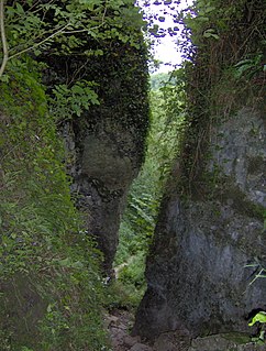
Ebbor Gorge is a limestone gorge in Somerset, England, designated and notified in 1952 as a 63.5-hectare (157-acre) biological Site of Special Scientific Interest in the Mendip Hills. It was donated to the National Trust in 1967 and is now managed by Natural England as a national nature reserve.

Bookham Commons are two commons, situated just to the north of the villages of Great Bookham and Little Bookham, in Surrey, England, 154.7 hectares in extent; the individual parts are named Great Bookham Common and Little Bookham Common. A group of dwellings known as the Isle of Wight is situated within the site, and a track, Common Road, leads to it from the northwest. Little Bookham Common lies south and west of this track, whereas Great Bookham Common lies to the east.

Compton Martin Ochre Mine is a 0.85 hectare geological and biological Site of Special Scientific Interest located on the north side of the Mendip Hills, immediately south west of Compton Martin village, Somerset, notified in 1988.

Axbridge Hill and Fry's Hill is a 64.8-hectare (160-acre) biological Site of Special Scientific Interest in the Mendip Hills, Somerset, notified in 1990. The hills are above the town of Axbridge, immediately to the east of Shute Shelve Hill.

Draycott Sleights is a 61.95 hectares biological Site of Special Scientific Interest at Draycott in the Mendip Hills, Somerset, England, notified in 1987. The name is pronounced locally as "Slates", presumably a variation on the Saxon word Slade meaning amongst other things hillside, rather than in the same manner as the Yorkshire place of the same spelling.
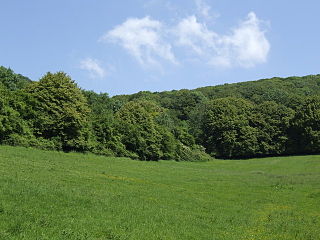
Cheddar Wood is an 86.9-hectare (215-acre) biological Site of Special Scientific Interest at Cheddar in the Mendip Hills, Somerset, England, notified in 1967.
St. Dunstan's Well Catchment is a Site of Special Scientific Interest, covering 39.8 hectares near Stoke St Michael in the Mendip Hills, Somerset, England. The site was notified in 1967. It is of both geological and biological significance.

Kingdown and Middledown is a 5.7 hectare biological Site of Special Scientific Interest near Cheddar in the Mendip Hills, Somerset, notified in 1991.

The Cheddar Complex is a 441.3 hectare biological Site of Special Scientific Interest near Cheddar around the Cheddar Gorge and north east to Charterhouse in the Mendip Hills, Somerset, England, notified in 1952.
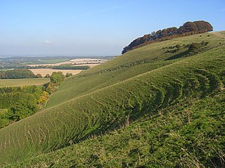
Ham Hill is an area of chalk downland in Wiltshire, England, on the steep banks running alongside the road from the village of Ham to Buttermere, close to the Berkshire border. A biological Site of Special Scientific Interest, notified in 1971, covers 1.5 hectares of the site; this designation is due to the site's species-rich plant and insect communities, which include some rare species. Notable among these is the musk orchid, which has been confirmed at only one other site in Wiltshire.
The Folkestone Downs are an area of chalk downland above Folkestone, where the eastern end of the North Downs escarpment meets the English Channel. Part of the Downs is the Folkestone to Etchinghill Escarpment Site of Special Scientific Interest, designated for its geological and biological interest.
Carmel National Nature Reserve lies close to the village of Carmel in Carmarthenshire. It lies south of Llandeilo not far from the main road to Llanelli. There is a small car park and picnic site for visitors, and footpaths for access. There is an explanatory notice board at the car park. The site is managed by the Wildlife Trust of South and West Wales and Natural Resources Wales (NRW).
There are several nature reserves in the surroundings of Nailsea, North Somerset, England, which is located at 51°25′55″N2°45′49″W.

Rough Bank, Miserden is a 9.2-hectare (23-acre) biological Site of Special Scientific Interest in Gloucestershire, notified in 1986. It was purchased by the wildlife charity Butterfly Conservation in 2012.

Beeding Hill to Newtimber Hill is a 321-hectare (790-acre) biological and geological Downland Site of Special Scientific Interest (SSSI) north of Shoreham-by-Sea in West Sussex. It is a Nature Conservation Review site, Grade 2, and it includes Devil's Dyke Geological Conservation Review site.
