
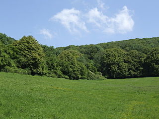
Folly Farm is a traditionally managed working farm and nature reserve run by the Avon Wildlife Trust. It is located between Stowey, Clutton and Stanton Wick in the civil parish of Stowey in the English county of Somerset.
Cheddar Wood is an 86.9-hectare (215-acre) biological Site of Special Scientific Interest at Cheddar in the Mendip Hills, Somerset, England, notified in 1967.

Rodney Stoke is a 69.6 hectare biological Site of Special Scientific Interest, just north of the village of Rodney Stoke in the Mendip Hills, Somerset, notified in 1957.

The Cheddar Complex is a 441.3-hectare (1,090-acre) biological Site of Special Scientific Interest near Cheddar around the Cheddar Gorge and north east to Charterhouse in the Mendip Hills, Somerset, England, notified in 1952.
Aller and Beer Woods is a 56.9 hectares biological Site of Special Scientific Interest. off the A372 Othery to Langport road near Aller in Somerset. It was notified in 1952.

Great Breach and Copley Woods is a 64.8 hectare biological Site of Special Scientific Interest 1 km south of Compton Dundon and 5 km south-east of Street in Somerset, England, notified in 1972.

Sevenoaks Gravel Pits is a 73.7-hectare (182-acre) biological Site of Special Scientific Interest on the northern outskirts of Sevenoaks in Kent. It is managed by Kent Wildlife Trust as the Sevenoaks Wildlife Reserve and Jeffery Harrison Visitor Centre.

Brampton Wood is a 132.1-hectare (326-acre) biological Site of Special Scientific Interest in Cambridgeshire. The site is west of Brampton in Cambridgeshire. It is managed by the Wildlife Trust for Bedfordshire, Cambridgeshire and Northamptonshire.
Fancott Woods and Meadows is a 13.3-hectare Site of Special Scientific Interest near the hamlet of Fancott in Bedfordshire. It was notified under Section 28 of the Wildlife and Countryside Act 1981, and the local planning authority is Central Bedfordshire Council. The site is managed by the Wildlife Trust for Bedfordshire, Cambridgeshire and Northamptonshire.

Wotton Hill is a hill on the edge of the Cotswold Hills in Gloucestershire, England, 0.5 miles (0.80 km) north of Wotton-under-Edge. The Cotswold Way passes over the hill.

Foxley Wood is a nature reserve in Foxley, Norfolk, England, the largest ancient woodland and coppice in Norfolk. The Norfolk Wildlife Trust, which manages this reserve, bought it in 1998. It is 123 hectares in size. It is a Site of Special Scientific Interest, a Nature Conservation Review site, Grade 2, and a National Nature Reserve.

Hobbs Quarry, Longhope is a 1-hectare (2.5-acre) geological and biological Site of Special Scientific Interest in Gloucestershire, England, notified in 1966. It is situated midway between Longhope and Dursley Cross in the Forest of Dean. Adjacent woods are Kiln Wood and Coleman's Wood. The site was managed by the Gloucestershire Wildlife Trust. Ownership changed to an independent Charitable Trust - Hobbs Nature Reserve Trust - on 1 August 2023. The Management Plan is similar to the one GWT had agreed with Natural England, combining conservation and research work on the geological exposures and preservation of the valuable natural environment. An explanatory website is under development to aid any groups planning educational visits. Local specialists are available to assist with these if required.

Collinpark Wood is a 66.69-hectare (164.8-acre) biological Site of Special Scientific Interest in Gloucestershire, notified in 1966, revised in 1974 and renotified in 1983. There was a boundary change in 1983. There are seven units of assessment. Unit 1 is a 15-hectare (37-acre) area owned and managed by the Gloucestershire Wildlife Trust. The trust purchased this part of the wood in 1979 with grant aid from WWF. The site is listed in the 'Forest of Dean Local Plan Review' as a Key Wildlife Site (KWS).

Upper Wye Gorge is a Site of Special Scientific Interest (SSSI), noted for its biological and geological characteristics, around Symonds Yat in the Wye Valley on the Wales–England border. The site is listed in the "Forest of Dean Local Plan Review" as a Key Wildlife Site (KWS).

Bull Cross, The Frith and Juniper Hill is a 42.33-hectare (104.6-acre) biological and geological Site of Special Scientific Interest in Gloucestershire, notified in 1954. The site is listed in the ‘Stroud District’ Local Plan, adopted November 2005, Appendix 6 as an SSSI and Regionally Important Geological Site (RIGS).

Lineover Wood is a 20.3-hectare (50-acre) biological Site of Special Scientific Interest in Gloucestershire, notified in 1986.
Shorn Cliff And Caswell Woods is a 69.2-hectare (171-acre) biological Site of Special Scientific Interest in Gloucestershire, notified in 1986. The site is listed in the 'Forest of Dean Local Plan Review' as a Key Wildlife Site (KWS).

Swain's Wood is a 16.2-hectare (40-acre) biological Site of Special Scientific Interest west of Turville in Buckinghamshire. It is in the Chilterns Area of Outstanding Natural Beauty, and is managed by the Berkshire, Buckinghamshire and Oxfordshire Wildlife Trust.

West Wood is a 23.6 hectares biological Site of Special Scientific Interest in Little Sampford, north of Thaxted in northwestern Essex. It is owned and managed by the Essex Wildlife Trust.

Castern Wood is a nature reserve of the Staffordshire Wildlife Trust. It is an ancient woodland, with scrub and grassland, on the eastern slopes of the Manifold Valley, about 1 mile south of Wetton, in Staffordshire, England.

