
The Blackdown Hills National Landscape is a National Landscape along the Somerset-Devon border in south-western England, which were designated in 1991 as an Area of Outstanding Natural Beauty (AONB). In November 2023, it has become 'Blackdown Hills National Landscape' The area encompasses a set of hills of the same name.
Blackdown Java was a Linux port of Sun Microsystems's Java virtual machine, developed by a group of volunteers led by Juergen Kreileder, Steve Byrne, and Karl Asha, and included a team of volunteers from around the globe. The first version, 1.0.2, was released in October 1996, predating Sun's official Linux port.

Pitminster is a village and civil parish in Somerset, England, situated 4 miles (6.4 km) south of Taunton. The parish has a population of 956. The parish also includes the villages of Angersleigh, Blagdon Hill and Staplehay. The village of Blagdon is now officially known as Blagdon Hill to distinguish it from Blagdon in North Somerset. Hillside hamlets in the parish comprise Feltham and Woodram, those on the lower plain in the north are Sellicks Green which is contiguous with Blagdon Hill, Duddlestone and Poundisford.

Buckland St Mary is a village and parish in Somerset, England, situated 6 miles (9.7 km) to the west of Ilminster and 8 miles (12.9 km) south of Taunton in the South Somerset district, close to the A303. The village has a population of 521. The parish is within the Blackdown Hills Area of Outstanding Natural Beauty and includes the hamlet of Birchwood.

Coombe Hill Canal lies in the Vale of Gloucester, south west England, north of Leigh and runs west 2.75 miles (4.43 km) from Coombe Hill Basin to the River Severn near Wainlode Hill. It opened in 1796 and closed 80 years later in 1876, after the only lock was damaged by flooding. The Gloucestershire Wildlife Trust purchased the Coombe Hill Canal nature reserve in 1985 and the area is managed by the trust. Adjacent to the Coombe Hill Canal is a large area of wet meadowland situated midway between Gloucester and Tewkesbury to the west of the A38, which was purchased by the trust in 1999. There is a north and a south meadow. This land and the Canal itself often flood in winter, which attracts hundreds of wildfowl.

Somerset is a rural county in the southwest of England, covering 4,171 square kilometres (1,610 sq mi). It is bounded on the north-west by the Bristol Channel, on the north by Bristol and Gloucestershire, on the north-east by Wiltshire, on the south-east by Dorset, and on the south west and west by Devon. It has broad central plains with several ranges of low hills. The landscape divides into four main geological sections from the Silurian through the Devonian and Carboniferous to the Permian which influence the landscape, together with water-related features.

Prairie Meadows is a Racino located in Altoona, Iowa, United States, it runs both Thoroughbreds and Quarter Horses at its meet from May to September.

Blackdown, or Black Down, summit elevation 279.7 metres (918 ft) AMSL, is the highest point in both the historic county of Sussex and the South Downs National Park. It is one of the highest points in the south east of England, exceeded by Walbury Hill, Leith Hill and Pilot Hill. Blackdown is protected as part of the South Downs National Park.

Black Down and Sampford Commons is a 155.2-hectare (384-acre) biological Site of Special Scientific Interest in Devon and Somerset, notified in 1952.

Freshmoor is an 11.2 hectare biological Site of Special Scientific Interest in Somerset, notified in 1989.
Long Lye is an 11.7 hectare biological Site of Special Scientific Interest at Buckland St Mary in the Blackdown Hills, Somerset, notified in 1988.

Prior's Park & Adcombe Wood is a 103.6 hectare biological Site of Special Scientific Interest south of Pitminster in Somerset, notified in 1952.
Ringdown is a 4.0 hectare (9.9 acre) biological Site of Special Scientific Interest west of Burnworthy in the Blackdown Hills of Somerset, notified in 1990.
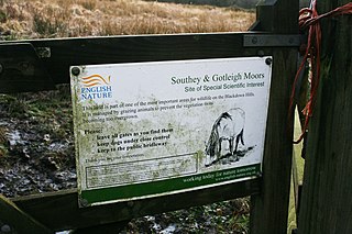
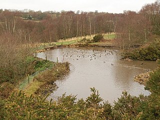
Southey and Gotleigh Moors is an 81.3 hectare biological Site of Special Scientific Interest on the Blackdown Hills in Somerset, notified in 1988.

Blackdown is a small village in western Dorset, England; situated 7 miles (11 km) west of Beaminster. With the creation of the new Dorset Council, Blackdown is now part of the new Marshwood Vale Ward. The local travel links are located 5 miles (8.0 km) from the village to Crewkerne railway station and 25 miles (40 km) to Exeter International Airport. The main road through the village is the B3165, connecting Blackdown and Lyme Regis. The village has a population of 128 according to the 2001 Census. The village and surrounding area makes up the Blackdown ward of the Broadwindsor Group Parish Council which besides the few houses in Blackdown includes Kittwhistle, Templeman's Ash (part), Laymore (part), Coles Cross, Causeway Lane, Venn, Southcoombe, Stoney Knapp, Schoolhouse Lane, Speckets Lane, Racedown, Cockpit, Horn Ash, Berechapel, two houses in Synderford, some houses in Birdsmoregate including the old Rose & Crown Public House now a private residence. The area is split between many postcodes partly due to the County boundary being realigned in the 1960s. Residents have postcodes with the main town as either Beaminster, Bridport, Crewkerne or Chard. Divisions also arise within telephone exchange areas, the BT phone box was removed from the centre of Blackdown in March 2017. Water services are provided by either South West Water or Wessex Water.

Iberia Flight 062 was a twin-engined Sud Aviation Caravelle registered EC-BDD operating a scheduled flight from Málaga Airport, Spain, to London Heathrow Airport. While on approach to Heathrow on 4 November 1967, the Caravelle descended far below the flight level assigned to it and flew into the southern slope of Blackdown Hill in West Sussex, killing all 37 on board.
