A valley is an elongated low area often running between hills or mountains, which will typically contain a river or stream running from one end to the other. Most valleys are formed by erosion of the land surface by rivers or streams over a very long period. Some valleys are formed through erosion by glacial ice. These glaciers may remain present in valleys in high mountains or polar areas.

A site of special scientific interest (SSSI) in Great Britain or an area of special scientific interest (ASSI) in the Isle of Man and Northern Ireland is a conservation designation denoting a protected area in the United Kingdom and Isle of Man. SSSI/ASSIs are the basic building block of site-based nature conservation legislation and most other legal nature/geological conservation designations in the United Kingdom are based upon them, including national nature reserves, Ramsar sites, Special Protection Areas, and Special Areas of Conservation. The acronym "SSSI" is often pronounced "triple-S I".

The Yorkshire Wolds are low hills in the counties of the East Riding of Yorkshire and North Yorkshire in north-eastern England. The name also applies to the district in which the hills lie.

Salisbury Plain is a chalk plateau in the south western part of central southern England covering 300 square miles (780 km2). It is part of a system of chalk downlands throughout eastern and southern England formed by the rocks of the Chalk Group and largely lies within the county of Wiltshire, but stretches into Hampshire.

Buckland Dinham is a small village near Frome in Somerset, England. The village has a population of 381. The village's main industry is farming, but the village is also a dormitory village for the nearby cities of Bath and Bristol.

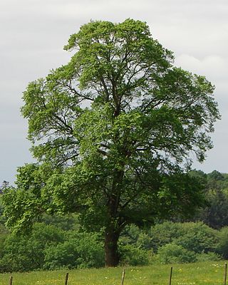
The field elm cultivar 'Atinia' , commonly known as the English elm, formerly common elm and horse may, and more lately the Atinian elm was, before the spread of Dutch elm disease, the most common field elm in central southern England, though not native there, and one of the largest and fastest-growing deciduous trees in Europe. R. H. Richens noted that elm populations exist in north-west Spain and northern Portugal, and on the Mediterranean coast of France that "closely resemble the English elm" and appear to be "trees of long standing" in those regions rather than recent introductions. Augustine Henry had earlier noted that the supposed English elms planted extensively in the Royal Park at Aranjuez from the late 16th century onwards, specimens said to have been introduced from England by Philip II and "differing in no respects from the English elm in England", behaved as native trees in Spain. He suggested that the tree "may be a true native of Spain, indigenous in the alluvial plains of the great rivers, now almost completely deforested".

Whatley is a small rural village and civil parish about 2.5 miles (4 km) west of Frome in the English county of Somerset. The parish lies south of Mells and north of Nunney, and includes the hamlets of Lower Whatley and Chantry.
James Fussell IV (1748–1832) was an iron magnate operating the Old Iron Works, Mells in Vallis Vale between Mells and Great Elm in Somerset. He was a promoter of the Dorset and Somerset Canal and the inventor of both the roller chain and the balance lock.
Ulmus minorMill., the field elm, is by far the most polymorphic of the European species, although its taxonomy remains a matter of contention. Its natural range is predominantly south European, extending to Asia Minor and Iran; its northern outposts are the Baltic islands of Öland and Gotland, although it may have been introduced by humans. The tree's typical habitat is low-lying forest along the main rivers, growing in association with oak and ash, where it tolerates summer floods as well as droughts.

Kingley Vale is a 204.4-hectare (505-acre) biological Site of Special Scientific Interest north of Chichester in West Sussex. It is also a Special Area of Conservation and a Nature Conservation Review site, Grade I. An area of 147.9 hectares is a national nature reserve.

Weston-in-Gordano SSSI is a 12.55 hectare geological Site of Special Scientific Interest near the village of Weston in Gordano, North Somerset, notified in 1993.

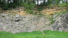
Old Iron Works, Mells is a 0.25 hectare biological Site of Special Scientific Interest, in the Wadbury Valley, south of the village of Mells in Somerset, notified in 1987. The site is a ruined iron works, which mainly produced agricultural edge-tools that were exported all over the world, and is now, in addition to its unique and major importance in relation to industrial archaeology, used as a breeding site by horseshoe bats. The block of buildings adjacent to the entrance is listed Grade II* and most of the rest of the site is a Scheduled Ancient Monument. It is included in the Heritage at Risk Register produced by English Heritage.

Great Elm is a village and civil parish between Mells and Frome in the Mendip district of Somerset, England. The parish includes the hamlet of Hapsford.

The geology of Wales is complex and varied; its study has been of considerable historical significance in the development of geology as a science. All geological periods from the Cryogenian to the Jurassic are represented at outcrop, whilst younger sedimentary rocks occur beneath the seas immediately off the Welsh coast. The effects of two mountain-building episodes have left their mark in the faulting and folding of much of the Palaeozoic rock sequence. Superficial deposits and landforms created during the present Quaternary period by water and ice are also plentiful and contribute to a remarkably diverse landscape of mountains, hills and coastal plains.

National Cycle Route 24, otherwise known as the Colliers Way currently runs from Dundas Aqueduct to Frome via Radstock, although it is intended to provide a continuous cycle route from Bristol and South Wales to Southampton and Portsmouth.

Mawrth Vallis is a valley on Mars, located in the Oxia Palus quadrangle at 22.3°N, 343.5°E with an elevation approximately two kilometers below datum. Situated between the southern highlands and northern lowlands, the valley is a channel formed by massive flooding which occurred in Mars’ ancient past. It is an ancient water outflow channel with light-colored clay-rich rocks.

The Geology of Yorkshire in northern England shows a very close relationship between the major topographical areas and the geological period in which their rocks were formed. The rocks of the Pennine chain of hills in the west are of Carboniferous origin whilst those of the central vale are Permo-Triassic. The North York Moors in the north-east of the county are Jurassic in age while the Yorkshire Wolds to the south east are Cretaceous chalk uplands. The plain of Holderness and the Humberhead levels both owe their present form to the Quaternary ice ages. The strata become gradually younger from west to east.

Wales, a country that is part of the United Kingdom, contains protected areas under various designations. The largest designation by land area is Wales' three national parks, followed by the five Areas of Outstanding Natural Beauty.
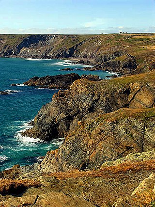
Caerthillian to Kennack is a coastal Site of Special Scientific Interest (SSSI) on the Lizard Peninsula in Cornwall, UK, noted for both its biological and geological characteristics. It is of great botanical importance, with several Red Data Book of rare and endangered plant species being found on the site, as well as a breeding site for Cornish choughs.