Leighton Moss RSPB reserve is a nature reserve in Lancashire, England, which has been in the care of the Royal Society for the Protection of Birds since 1964. It is situated at Silverdale near Carnforth, on the edge of Morecambe Bay and in the Arnside and Silverdale Area of Outstanding Natural Beauty.

Bracklesham Bay is a 200.6-hectare (496-acre) biological and geological Site of Special Scientific Interest in West Sussex. It is a Geological Conservation Review site.

Edington is a rural village, situated on the north side of the Polden Hills in the Sedgemoor district of Somerset, England.

Somerset is a rural county in the southwest of England, covering 4,171 square kilometres (1,610 sq mi). It is bounded on the north-west by the Bristol Channel, on the north by Bristol and Gloucestershire, on the north-east by Wiltshire, on the south-east by Dorset, and on the south west and west by Devon. It has broad central plains with several ranges of low hills. The landscape divides into four main geological sections from the Silurian through the Devonian and Carboniferous to the Permian which influence the landscape, together with water-related features.

Abernethy Forest is a remnant of the Caledonian Forest in Strathspey, in the Highland council area of Scotland. It lies within the Cairngorms National Park, close to the villages of Nethy Bridge, Boat of Garten, and Aviemore. The forest is an RSPB reserve, close to Loch Garten Osprey Centre, which is also owned by the RSPB. It is popular with walkers, as there are various trails throughout the reserve. The forest forms part of the wider Abernethy National Nature Reserve.

King's Sedgemoor is a piece of rich animal habitat and farming land, that forms part of the Somerset Levels and Moors in South West England.

King's Sedgemoor Drain is an artificial drainage channel which diverts the River Cary in Somerset, England along the southern flank of the Polden Hills, to discharge into the River Parrett at Dunball near Bridgwater. As the name suggests, the channel is used to help drain the peat moors of King's Sedgemoor. There was opposition to drainage schemes from the local inhabitants, who feared that they would lose their common grazing rights. However, the main channel was constructed between 1791 and 1795, and despite some defects, brought some relief from flooding to the area.

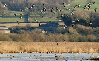
Catcott, Edington and Chilton Moors SSSI is a 1083 hectare biological Site of Special Scientific Interest in Somerset, England notified in 1967. It is close to the villages of Edington and Catcott.

Hurcott Farm is a 26.3 hectare geological Site of Special Scientific Interest in Somerset, notified in 1993.

Lodmoor is a Site of Special Scientific Interest (SSSI), RSPB reserve and country park in Dorset, England. The country park features a visitor centre, model railway and pitch and putt golf course. The SSSI has a wetland habitat with native birds that are rare in the UK and a range of migratory species.

Catcott is a rural village and civil parish, situated close to Edington 7 miles (11.3 km) to the east of Bridgwater on the Somerset Levels to the north of the Polden Hills in the Sedgemoor district of Somerset, England.

Chilton Polden is a rural village and civil parish, situated close to Edington on the Somerset Levels to the north of the Polden Hills in the Sedgemoor district of Somerset, England.

Middlezoy is a village and civil parish on the River Parrett as it crosses the Somerset Levels in the Sedgemoor district of Somerset, England. The civil parish contains the hamlet of Greylake.

Newport Wetlands is a wildlife reserve covering parts of Uskmouth, Nash and Goldcliff, in the south-east of the city of Newport, South Wales.

Ham Wall is an English wetland National Nature Reserve (NNR) 4 kilometres (2.5 mi) west of Glastonbury on the Somerset Levels. It is managed by the Royal Society for the Protection of Birds (RSPB). Since the last Ice Age, decomposing plants in the marshes of the Brue valley in Somerset have accumulated as deep layers of peat that were commercially exploited on a large scale in the twentieth century. Consumer demand eventually declined, and in 1994 the landowners, Fisons, gave their old workings to what is now Natural England, who passed the management of the 260 hectares Ham Wall section to the RSPB.

Marazion Marsh is a Royal Society for the Protection of Birds (RSPB) reserve situated in a shallow river valley, half a kilometre to the west of Marazion, Cornwall, UK. It is separated from the coast by a shingle bar and small sand dune system and contains Cornwall's largest reed bed.

Minsmere–Walberswick Heaths and Marshes are a Special Area of Conservation and Site of Special Scientific Interest in the English county of Suffolk. The site is located on the North Sea coast between Southwold and Sizewell, extending over an area of coastline around 7 miles (11 km) in length. The site is also designated as a Special Protection Area, part of the Minsmere–Walberswick European Marine Site and contains areas designated as Ramsar sites and Natura 2000 sites. It lies within the Suffolk Coast and Heaths Area of Outstanding Natural Beauty and is made up of a "complex mosaic" of marshes, reed beds, shingle banks and lowland heath habitats.
The Avalon Marshes Partnership is a group of conservation organisations working together in the Somerset Levels. The members are Natural England,, the Royal Society for the Protection of Birds (RSPB), the Somerset Wildlife Trust the Hawk and Owl Trust, Historic England, South West Heritage Trust and the Environment Agency. Between 2012 and 2016 the scheme was supported by a Heritage Lottery Fund grant of £1,772,500 with additional investment of £920,080 from other sources. The Avalon Marshes Centre, run by Natural England, is near the Ham Wall reserve. The network of reserves and private land managed for conservation in the Avalon marshes means that wetland management can be carried out on a landscape scale.

