Doulting Railway Cutting

Last updated

Doulting Railway Cutting
Site of Special Scientific Interest
Doulting, East Somerset Railway - geograph.org.uk - 83606.jpg
Somerset UK location map.svg
Red pog.svg
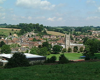
Location within Somerset
Area of Search Somerset
Grid reference ST648424
Coordinates 51°10′47″N2°30′18″W / 51.17974°N 2.50496°W / 51.17974; -2.50496 Coordinates: 51°10′47″N2°30′18″W / 51.17974°N 2.50496°W / 51.17974; -2.50496
Interest Geological
Area 2.8 hectares (0.028 km2; 0.011 sq mi)
Notification 1971 (1971)
Natural England website

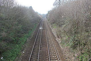
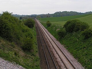
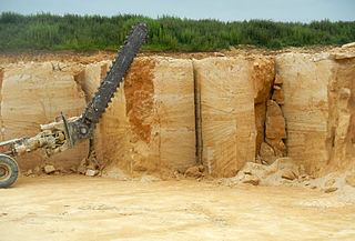
Doulting Railway Cutting (grid reference ST648424 ) is a 2.8 hectare geological Site of Special Scientific Interest in Somerset, notified in 1971.

Ordnance Survey National Grid System of geographic grid references used in Great Britain

The Ordnance Survey National Grid reference system is a system of geographic grid references used in Great Britain, distinct from latitude and longitude. It is often called British National Grid (BNG).

Hectare metric unit of area

The hectare is an SI accepted metric system unit of area equal to a square with 100-metre sides, or 10,000 m2, and is primarily used in the measurement of land. There are 100 hectares in one square kilometre. An acre is about 0.405 hectare and one hectare contains about 2.47 acres.

Somerset County of England

Somerset is a county in South West England which borders Gloucestershire and Bristol to the north, Wiltshire to the east, Dorset to the south-east and Devon to the south-west. It is bounded to the north and west by the Severn Estuary and the Bristol Channel, its coastline facing southeastern Wales. Its traditional border with Gloucestershire is the River Avon. Somerset's county town is Taunton.

The cutting was made in the 1850s for the East Somerset Railway which still runs steam trains through the cutting today.

East Somerset Railway transport company

The East Somerset Railway is a 2 12-mile (4 km) heritage railway in Somerset, running between Cranmore and Mendip Vale. Prior to the Beeching Axe, the railway was once part of the former Cheddar Valley line that ran from Witham to Yatton, meeting the Somerset and Dorset Joint Railway at Wells.

It shows rocks of the Middle Jurassic period including both the Inferior Oolite/Great Oolite Junction and the Bajocian-Bathonian stage boundary.

The Middle Jurassic is the second epoch of the Jurassic Period. It lasted from about 174 to 163 million years ago. Fossil-bearing rocks from the Middle Jurassic are relatively rare, but some important formations include the Forest Marble Formation in England, the Kilmaluag Formation in Scotland, the Daohugou Beds in China, Itat Formation in Russia, and the Isalo III Formation of western Madagascar.

Oolite Sedimentary rock formed from ooids

Oolite or oölite is a sedimentary rock formed from ooids, spherical grains composed of concentric layers. The name derives from the Ancient Greek word ᾠόν for egg. Strictly, oolites consist of ooids of 0.25–2 millimetres' diameter; rocks composed of ooids larger than 2 mm are called pisolites. The term oolith can refer to oolite or individual ooids.

The Great Oolite is a geological formation in Europe. It dates back to the Middle Jurassic.

Sources

Related Research Articles

Dundry Hill mountain in United Kingdom

Dundry Hill is immediately south of Bristol, England: it includes farmland, a small number of houses and a church. It stretches east-west for some two miles.

Bruton town and parish in Somerset, England

Bruton is a small town, electoral ward, and civil parish in Somerset, England, situated on the River Brue along the A359 between Frome and Yeovil. It is 7 miles south-east of Shepton Mallet, just south of Snakelake Hill and Coombe Hill, 10 miles north-west of Gillingham and 12 miles south-west of Frome in the South Somerset district. The town and electoral ward have a population of 2,907. The parish includes the hamlets of Wyke Champflower and Redlynch.

Shepton Montague village in the United Kingdom

Shepton Montague is a village and civil parish in Somerset, England. It is situated on the River Pitt in the South Somerset district midway between Wincanton, Bruton and Castle Cary.

Barns Batch Spinney

Barns Batch Spinney is a 0.06-hectare geological Site of Special Scientific Interest near the village of Dundry, North Somerset, notified in 1987.

Dundry Main Road South Quarry

Dundry Main Road South Quarry is a 0.7 hectare geological Site of Special Scientific Interest near the village of East Dundry, North Somerset, notified in 1974.

North Road Quarry, Bath

North Road Quarry, Bath is a 0.3 hectare geological Site of Special Scientific Interest close to Sham Castle in the city of Bath, Somerset, notified in 1990.

Shiplate Slait

Shiplate Slait is a 33.9 hectare biological Site of Special Scientific Interest near the village of Loxton, within the Mendip Hills Area of Outstanding Natural Beauty, North Somerset, notified in 1987.

Cheddar Complex

The Cheddar Complex is a 441.3 hectare biological Site of Special Scientific Interest near Cheddar around the Cheddar Gorge and north east to Charterhouse in the Mendip Hills, Somerset, notified in 1952.

Bruton railway cutting geological site in Bruton, Somerset, England

Bruton Railway Cutting is a 1.7 hectare geological Site of Special Scientific Interest at Bruton in Somerset, notified in 1971.

Shepton Montague Railway Cutting

Shepton Montague Railway Cutting is a 1.61 hectare geological Site of Special Scientific Interest at Shepton Montague in Somerset, notified in 1992.

Godminster Lane Quarry and Railway Cutting

Godminster Lane Quarry and Railway Cutting is a 0.8 hectare geological Site of Special Scientific Interest at Pitcombe in Somerset, notified in 1971.

Langport Railway Cutting

Langport Railway Cutting is a 0.5 hectare geological Site of Special Scientific Interest at Langport in Somerset, England, notified in 1992. It is a Geological Conservation Review site.

Laycock Railway Cutting

Laycock Railway Cutting is a 1.3 hectare geological Site of Special Scientific Interest near Milborne Port in Somerset, notified in 1993. It is a Geological Conservation Review site.

Maesbury Railway Cutting

Maesbury Railway Cutting is a 2 hectare geological Site of Special Scientific Interest between East Horrington and Gurney Slade in Somerset, notified in 1995.

Seavington St. Mary SSSI, Somerset

Seavington St. Mary is a 0.3 hectare geological Site of Special Scientific Interest near the village of Seavington St Mary in Somerset, notified in 1971.

Wookey railway station

Wookey railway station was a station on the Bristol and Exeter Railway's Cheddar Valley line in Somerset, England. The site is a 0.04 hectare geological Site of Special Scientific Interest between Wells and Wookey Hole

Pitcombe village and parish in Somerset, England

Pitcombe is a village and civil parish 1 mile (2 km) south-west of Bruton and 5 miles (8 km) from Wincanton in Somerset, England. It has a population of 532. The parish includes the hamlets of Cole and Godminster.

Doulting Stone Quarry stone quarry in the United Kingdom

Doulting Stone Quarry is a limestone quarry at Doulting, on the Mendip Hills, Somerset, England.

Harford Railway Cutting

Harford Railway Cutting is a 1.2-hectare (3.0-acre) geological Site of Special Scientific Interest in Gloucestershire, notified in 1974. The site is listed in the 'Cotswold District' Local Plan 2001-2011 as a Regionally Important Geological Site (RIGS).