
A site of special scientific interest (SSSI) in Great Britain or an area of special scientific interest (ASSI) in the Isle of Man and Northern Ireland is a conservation designation denoting a protected area in the United Kingdom and Isle of Man. SSSI/ASSIs are the basic building block of site-based nature conservation legislation and most other legal nature/geological conservation designations in the United Kingdom are based upon them, including national nature reserves, Ramsar sites, Special Protection Areas, and Special Areas of Conservation. The acronym "SSSI" is often pronounced "triple-S I".

The Jasmund National Park is a nature reserve on the Jasmund peninsula, in the northeast of Rügen island in Mecklenburg-Vorpommern, Germany. It is famous for containing the largest chalk cliffs in Germany, the Königsstuhl. These cliffs are up to 161 m (528 ft) above the Baltic Sea. The beech forests behind the cliffs are also part of the national park.

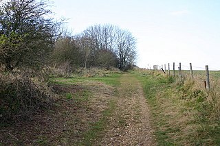
The South Downs are a range of chalk hills in the south-eastern coastal counties of England that extends for about 260 sq mi (670 km2) across the south-eastern coastal counties of England from the Itchen valley of Hampshire in the west to Beachy Head, in the Eastbourne Downland Estate, East Sussex, in the east. The Downs are bounded on the northern side by a steep escarpment, from whose crest there are extensive views northwards across the Weald. The South Downs National Park forms a much larger area than the chalk range of the South Downs, and includes large parts of the Weald.

The White Cliffs of Dover is the region of English coastline facing the Strait of Dover and France. The cliff face, which reaches a height of 350 feet (110 m), owes its striking appearance to its composition of chalk accented by streaks of black flint, deposited during the Late Cretaceous. The cliffs, on both sides of the town of Dover in Kent, stretch for eight miles (13 km). The White Cliffs of Dover form part of the North Downs. A section of coastline encompassing the cliffs was purchased by the National Trust in 2016.

The Chalk Group is the lithostratigraphic unit which contains the Upper Cretaceous limestone succession in southern and eastern England. The same or similar rock sequences occur across the wider northwest European chalk 'province'. It is characterised by thick deposits of chalk, a soft porous white limestone, deposited in a marine environment.
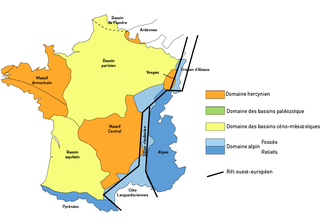
The Paris Basin is one of the major geological regions of France. It developed since the Triassic over remnant uplands of the Variscan orogeny. The sedimentary basin, no longer a single drainage basin, is a large sag in the craton, bordered by the Armorican Massif to the west, the Ardennes-Brabant axis to the north, the Massif des Vosges to the east, and the Massif Central to the south.

Catton Grove Chalk Pit is a 0.6-hectare (1.5-acre) geological Site of Special Scientific Interest on the northern outskirts of Norwich in Norfolk. It is a Geological Conservation Review site.
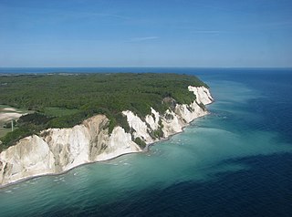
Møns Klint is a 6 km stretch of limestone and chalk cliffs along the eastern coast of the Danish island of Møn in the Baltic Sea. Some of the cliffs fall a sheer 120 m to the sea below. The highest cliff is Dronningestolen, which is 128 m above sea level. The area around Møns Klint consists of woodlands, pastures, ponds and steep hills, including Aborrebjerg which, with a height of 143 m, is one of the highest points in Denmark. The cliffs and adjacent park are now protected as a nature reserve. Møns Klint receives around 250,000 visitors a year. There are clearly marked paths for walkers, riders and cyclists. The path along the cliff tops leads to steps down to the shore in several locations.

Brighton to Newhaven Cliffs is a 165.4-hectare (409-acre) biological and geological Site of Special Scientific Interest and Geological Conservation Review site, which stretches along the coast between Brighton and Newhaven in East Sussex. An area of 16.4 hectares is the Castle Hill, Newhaven Local Nature Reserve
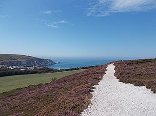
Headon Warren and West High Down is a 276.3-hectare (683-acre) Site of Special Scientific Interest (SSSI) located at the westernmost end of the Isle of Wight. The SSSI encompasses Headon Warren, a heather clad down to the north, the chalk downs of West High Down and Tennyson Down to the south, and the Needles, The Needles Batteries and Alum Bay to the west.

Fossiliferous limestone is any type of limestone, made mostly of calcium carbonate (CaCO3) in the form of the minerals calcite or aragonite, that contains an abundance of fossils or fossil traces. The fossils in these rocks may be of macroscopic or microscopic size. The sort of macroscopic fossils often include crinoid stems, brachiopods, gastropods, and other hard shelled mollusk remains.

The Chafford Gorges Nature Park is a 200-acre (81 ha) nature reserve located in Chafford Hundred, England and managed by the Essex Wildlife Trust. It includes two Sites of Special Scientific Interest. Grays Thurrock Chalk Pit has been designated for its biological interest, and Lion Pit for geological interest.

Stevns Klint, known as the Cliffs of Stevns in English, is a white chalk cliff located some 6 km (3.7 mi) southeast of Store Heddinge on the Danish island of Zealand. Stretching 17 km (11 mi) along the coast, it is of geological importance as one of the best exposed Cretaceous-Tertiary (K/T) boundaries in the world. Subject to frequent erosion, the cliff rises to a height of up to 40 m (130 ft). Because of its exceptional fossil record, Stevens Klint was inscribed on the UNESCO World Heritage List in 2014.
Hill End Pit is a 0.7-hectare (1.7-acre) nature reserve on the site of a former chalk pit, in St Paul's Walden in North Hertfordshire. It was formerly managed by the Herts and Middlesex Wildlife Trust (HMWT). In February 2016 HMWT announced that three sites, Barkway Chalk Pit, Hill End Pit and Pryor's Wood, which HMWT managed on behalf of their owner, North Hertfordshire District Council, were to return to Council management as the Trust was no longer able to meet the cost. It has the largest colony of Azeca goodalli snails in Hertfordshire. Plants include viper's bugloss, cowslip and marjoram, there are butterflies such as common blue and gatekeeper, and many birds including woodpeckers.

Kensworth Chalk Quarry is a 131.3-hectare (324-acre) geological Site of Special Scientific Interest in Kensworth in Bedfordshire. It was notified under Section 28 of the Wildlife and Countryside Act 1981, and the local planning authority is Central Bedfordshire.

Barrington Chalk Pit is a 97.1-hectare (240-acre) geological Site of Special Scientific Interest near Barrington in Cambridgeshire. It is a Geological Conservation Review site.

Fognam Chalk Quarry is a 3-hectare (7.4-acre) geological Site of Special Scientific Interest west of Upper Lambourn in Berkshire. It is a Geological Conservation Review site. It is in the North Wessex Downs.
Lancing Ring is a 29.4-hectare (73-acre) Local Nature Reserve in Lancing in West Sussex. It is owned and managed by Adur District Council.

Chinnor Chalk Pit is a 20.4-hectare (50-acre) geological Site of Special Scientific Interest south of Chinnor in Oxfordshire. It is a Geological Conservation Review site.
