
Inver Grove Heights is a city in Dakota County, Minnesota, United States. The population was 33,880 at the 2010 census.

Franconia is a census-designated place (CDP) in Fairfax County, Virginia, United States. The population was 18,245 at the 2010 census, down from 31,907 in 2000 due to the splitting off of part of it to form the Kingstowne CDP.
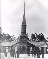
Poplar Grove National Cemetery is near Petersburg, Virginia, and is managed as part of Petersburg National Battlefield.
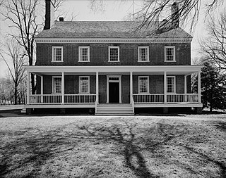
Historic Locust Grove is a 55-acre 18th-century farm site and National Historic Landmark situated in eastern Jefferson County, Kentucky. The site is owned by the Louisville Metro government, and operated as a historic interpretive site by Historic Locust Grove, Inc.

Ringland is both an electoral ward (district) and community (parish) of the city of Newport, South Wales.

Hopelawn is an unincorporated community located within Woodbridge Township in Middlesex County, New Jersey, United States.

Marjorie Kinnan Rawlings Historic State Park is a Florida State Park and historic site located on the former homestead of Pulitzer Prize-winning Florida author Marjorie Kinnan Rawlings (1896-1953). A National Historic Landmark, it is located in Cross Creek, Florida, between Ocala and Gainesville at 18700 South County Road 325.

Sky Meadows State Park is a 1,862-acre (754 ha) park in the Virginia state park system. It is located in extreme northwest Fauquier County, Virginia in the Blue Ridge Mountains, near Paris, Virginia. It is about an hour outside of the Washington, D.C. metro region.
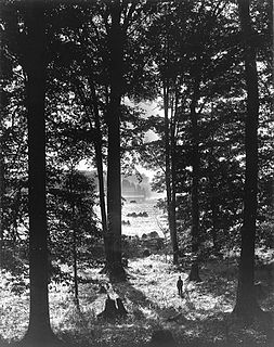
The foundational event of the Latter Day Saint movement took place in what is commonly referred to as the Sacred Grove. This Grove is a forested area of western New York near the home of Joseph Smith. It is the location where Smith said he had his First Vision, an important theophany in the movement's theology, occurring in the spring of 1820.
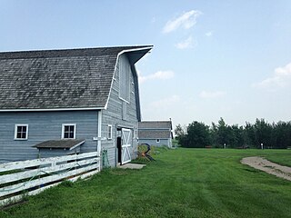
Seager Wheeler's Maple Grove Farm is a National Historic Site of Canada. Seager Wheeler's Maple Grove Farm was a farm owned and operated by agronomist Seager Wheeler (1868–1961) "Wheat King of the Prairies" or "The Wheat Wizard of Rosthern" who developed dry land farming techniques as well as fruit and wheat strains which could grow in a short prairie growing season followed by harsh winters. Seager came to Canada in 1885 and applied for his own homestead in 1890. His original homestead was located at NE Section 16 Township 38 Range 4 West of the 3rd Meridian, and he was aided by a loan from the Temperance Colonization Society Limited - Toronto Whereas the nearest present day town of Rosthern, Saskatchewan is located at Sec.35, Twp.42, R.3, W3. To get to the restored Seager Wheeler Maple Grove 185-acre (0.75 km2) Farm travel 7 km east of Rosthern. Five separate entries of wheat which were grown at this farm location during 1911 to 1918 won World Wheat Championships. Morris Bodnar, Member of Parliament for Saskatoon—Dundurn, commemorated Seager Wheeler's Maple Grove Farm as a National Historic Site of Canada on August 3, 1996 The site is honoured as the location where hardy wheat and fruit strains were developed which were well suited to the prairie climate and growing season.
The Thomas Cole House, also known as Cedar Grove or the Thomas Cole National Historic Site, is a National Historic Landmark that includes the home and the studio of painter Thomas Cole, founder of the Hudson River School of American painting. It is located at 218 Spring Street, Catskill, NY, United States. The site provided Thomas Cole with a residence and studio from 1833 through his death in 1848.

Long Hunter State Park is a state park in Davidson County and Rutherford County, Tennessee, located in the southeastern United States. The park is mostly situated along the eastern shores of Percy Priest Lake, an artificial lake created by an impoundment of the Stones River.

Twin Groves Wind Farm is a wind farm in the U.S. state of Illinois, near the villages of Arrowsmith, Saybrook, and Ellsworth in McLean County. It consists of 240 operating wind turbines. Each wind turbine stands 280 ft (80 m) tall and has three 120-foot-long (39 m) blades. The wind farm was constructed from 2007 to February 2008. Twin Groves was the largest utility-scale wind farm east of the Mississippi River upon completion.
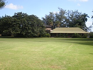
Grove Farm is a historic agricultural site on Kauai in the Hawaiian Islands.

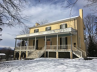
Spring Grove Farm and Distillery is a historic farm complex and distillery site located at Antrim Township in Franklin County, Pennsylvania, USA. The house was built in 1867, and is a two-story, "T"-shaped, brick dwelling in the Greek Revival style. Also on the property are a contributing two-story, four bay brick building believed to have housed a cooper's shop and residence, brick summer kitchen, brick smoke house, frame pumphouse, large brick end bank barn with a slate roof, frame wagon shed, brick carriage house, stone mill (1803) and the site of the Spring Grove Distillery. The distiller ceased to operate in 1920.

James Monroe Family Home Site, also known as James Monroe's Birthplace, is a historic archaeological site located near Oak Grove and Colonial Beach, Westmoreland County, Virginia. The site includes the ruins of the Monroe Family Home and birthplace of President James Monroe (1758-1831), which were uncovered in 1976, by a team from the College of William & Mary. Monroe spent his entire youth working the farm until he left for his education at the College of William & Mary. The archaeological team uncovered a house foundation measuring 20 feet by 58 feet. The known 1845 etchings of the birth home indicate a small four room, rough cut wooden farm house with few outbuildings on a 500-acre farm filled with wetlands. The archaeological study clearly indicated that James Monroe's beginnings were humble.
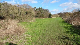
Grove Farm is an 8 hectare Local Nature Reserve (LNR) in Greenford in the London Borough of Ealing. It was declared an LNR in 2002 by Ealing Council, which owns and manages the site.


