West Moor SSSI

Last updated
West Moor
Site of Special Scientific Interest
Westmoor.jpg
Somerset UK location map.svg
Red pog.svg
Location within Somerset
Area of Search Somerset
Grid reference ST420220
Coordinates 50°59′40″N2°49′40″W / 50.99446°N 2.82783°W / 50.99446; -2.82783 Coordinates: 50°59′40″N2°49′40″W / 50.99446°N 2.82783°W / 50.99446; -2.82783
Interest Biological
Area 213 hectares (2.13 km2; 0.82 sq mi)
Notification 1985 (1985)
Natural England website

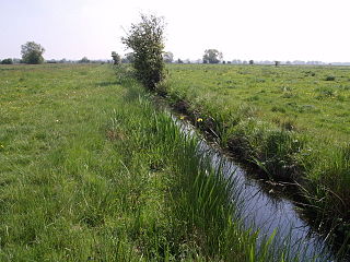
West Moor (grid reference ST420220 ) is a 213.0 hectare (526.3 acre) biological Site of Special Scientific Interest on the River Parrett in Somerset, notified in 1985.

Ordnance Survey National Grid System of geographic grid references used in Great Britain

The Ordnance Survey National Grid reference system is a system of geographic grid references used in Great Britain, distinct from latitude and longitude. It is often called British National Grid (BNG).

Hectare metric unit of area

The hectare is an SI accepted metric system unit of area equal to a square with 100-metre sides, or 10,000 m2, and is primarily used in the measurement of land. There are 100 hectares in one square kilometre. An acre is about 0.405 hectare and one hectare contains about 2.47 acres.

River Parrett River in the United Kingdom

The River Parrett flows through the counties of Dorset and Somerset in South West England, from its source in the Thorney Mills springs in the hills around Chedington in Dorset. Flowing northwest through Somerset and the Somerset Levels to its mouth at Burnham-on-Sea, into the Bridgwater Bay nature reserve on the Bristol Channel, the Parrett and its tributaries drain an area of 660 square miles (1,700 km2) – about 50 per cent of Somerset's land area, with a population of 300,000.

West Moor lies south of Curry Rivel, Langport, and Drayton, and northwest of Kingsbury Episcopi and is part of the extensive grazing marsh grasslands and ditch systems of the Somerset Levels and moors. The site contains some of the most diverse aquatic plant communities in the country. Rhynes often have a rich aquatic flora Frogbit (Hydrocharis morsus-ranae). A rich invertebrate fauna, with many nationally and locally rare species is associated with the botanical diversity of the ditches. [1]

Curry Rivel village in the United Kingdom

Curry Rivel is a village and civil parish in Somerset, England, situated 6 miles (9.7 km) west of Somerton and 10 miles (16.1 km) east of Taunton in the South Somerset district. The parish has a population of 2,148. The parish includes the hamlet of Burton Pynsent.

Langport a town in South Somerset, United Kindom

Langport is a small town and civil parish in Somerset, England, 5 miles (8.0 km) west of Somerton in the South Somerset district. The parish has a population of 1,081. Langport is contiguous with Huish Episcopi, a separate parish that includes much of the town's outskirts.

Drayton, Somerset village in the United Kingdom

Drayton is a village and civil parish in Somerset, England, focussed less than a mile from Curry Rivel and five miles southwest of Somerton in the South Somerset district. It adjoins the River Isle, near its confluence with the Parrett, and the former Westport Canal. The parish includes the hamlet of Midelney.

Related Research Articles

Gordano Valley

Gordano is an area of North Somerset, in England. It has been designated as a National Nature Reserve.

Geology of Somerset

Somerset is a rural county in the southwest of England, covering 4,171 square kilometres (1,610 sq mi). It is bounded on the north-west by the Bristol Channel, on the north by Bristol and Gloucestershire, on the north-east by Wiltshire, on the south-east by Dorset, and on the south west and west by Devon. It has broad central plains with several ranges of low hills. The landscape divides into four main geological sections from the Silurian through the Devonian and Carboniferous to the Permian which influence the landscape, together with water-related features.

Kings Sedgemoor

King's Sedgemoor is a piece of rich animal habitat and farming land, that forms part of the Somerset Levels and Moors in South West England.

Biddle Street, Yatton

Biddle Street, Yatton is a 44.8 hectare biological Site of Special Scientific Interest (SSSI) near the village of Yatton in North Somerset, notified in 1994.

Yanal Bog

Yanal Bog is a 1.6 hectare biological Site of Special Scientific Interest on the southern edge of the North Somerset Levels, just north of the village of Sandford, North Somerset. It was notified as an SSSI in 1988.

Tickenham, Nailsea and Kenn Moors SSSI

Tickenham, Nailsea and Kenn Moors SSSI is a 129.4 hectare biological Site of Special Scientific Interest between Tickenham, Nailsea and Kenn on the North Somerset Levels, notified in 1995.

Catcott, Edington and Chilton Moors

Catcott, Edington and Chilton Moors SSSI is a 1083 hectare biological Site of Special Scientific Interest in Somerset, England notified in 1967. It is close to the villages of Edington and Catcott.

Hardington Moor

Hardington Moor is an 8.7 hectare biological Site of Special Scientific Interest between Hardington Mandeville and West Coker in Somerset, notified in 1994.

North Moor

North Moor is a 676.3 hectare biological Site of Special Scientific Interest near Lyng in Somerset, notified in 1986.

Curry and Hay Moors

Curry and Hay Moors is a 472.8 hectare biological Site of Special Scientific Interest in Somerset, notified in 1992.

Lyng, Somerset farm village in the United Kingdom

Lyng is a civil parish in Somerset, England, comprising the villages of West Lyng and East Lyng and the hamlet of Bankland.

Langmead and Weston Level

Langmead and Weston Level is a 168.8 hectare biological Site of Special Scientific Interest in Somerset, notified in 1991.

Moorlinch SSSI

Moorlinch is a 226.0 hectare biological Site of Special Scientific Interest at Moorlinch in Somerset, notified in 1985.

Southlake Moor

Southlake Moor is a 196.1 hectare biological Site of Special Scientific Interest near Burrow Mump and Burrowbridge in Somerset, notified in 1985.

Tealham and Tadham Moors

Tealham and Tadham Moors is a 917.6 hectare biological Site of Special Scientific Interest south of Wedmore in Somerset, notified in 1985.

West Sedgemoor area of the Somerset Levels, in Somerset, England


West Sedgemoor or West Sedge Moor is an area of the Somerset Levels, in Somerset, England, around 8 miles east of Taunton, which approximately coincides with the West Sedgemoor biological Site of Special Scientific Interest, a 1,016 hectare site notified as an SSSI in 1983. It is a flat, low-lying area of fields and meadows separated by water-filled rhynes and ditches. It is subject to controlled flooding in winter. It is drained by the River Parrett.

Westhay Heath

Westhay Heath is a 25.9 hectare biological Site of Special Scientific Interest 2km west of Westhay village in Somerset, notified in 1990.

Westhay Moor

Westhay Moor is a 513.7-hectare (1,269-acre) biological Site of Special Scientific Interest 2.5 kilometres (1.6 mi) north-east of Westhay village and 4 kilometres (2.5 mi) from Wedmore in Somerset, England, notified in 1971. Westhay Moor is also notified as part of the Somerset Levels and Moors Special Protection Area under the EU Birds Directive and as a Ramsar Site, and a National Nature Reserve.

Wet Moor

Wet Moor is a 491.0-hectare biological Site of Special Scientific Interest east of Muchelney in Somerset, notified in 1985.

Godney English village

Godney is a village and civil parish near Glastonbury on the River Sheppey on the Somerset Levels in the Mendip district of Somerset, England.

References

  1. "West Moor" (PDF). English Nature. Retrieved 2006-08-21.