
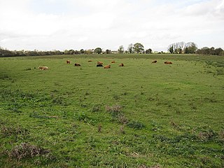
Brewham is a civil parish in Somerset, England, consisting of the villages of North Brewham and South Brewham, on either side of the river in the Brue Valley 3 miles (4.8 km) east of Bruton and 9 miles (14.5 km) south-west of Frome. The parish has a population of 441.

Long Dole Wood and Meadows SSSI is a 9.8 hectares biological Site of Special Scientific Interest (SSSI) between the villages of Farrington Gurney and Hinton Blewitt in Bath and North East Somerset, notified in 1987.

Babcary Meadows is a 13.6 hectares biological Site of Special Scientific Interest north of Babcary in Somerset, notified in 1988.
Stowell Meadow is a 2.8 hectare biological Site of Special Scientific Interest near Tatworth in Somerset, notified in 1987.

Whitevine Meadows is a 13.0 hectare biological Site of Special Scientific Interest east of North and South Perrott in Somerset, notified in 1979.

Ashleworth Ham is a 104.73-hectare (258.8-acre) biological Site of Special Scientific Interest. It is a large area of grassland on the Severn floodplain, north of Ashleworth in Gloucestershire, England. It is registered as a Site of Special Scientific Interest and was notified in 1974 and renotified in 1985. Ashleworth Ham received this designation because it is one of three sites in the Severn Vale where migratory waterfowl winter.
Stanley Bank Meadow is a 14.9-hectare (37-acre) Site of Special Scientific Interest situated 2.8km north-east of St Helens. The site was notified in 1988 due to its biological features which is predominantly damp unimproved neutral grassland, which is a rare habitat in Merseyside. It is also part of a larger area which is a Local Nature Reserve called Stanley Bank.
Soham Wet Horse Fen is a 33.8-hectare (84-acre) biological Site of Special Scientific Interest east of Soham in Cambridgeshire. A 3.6-hectare (8.9-acre) field in the north-west corner is managed by the Wildlife Trust for Bedfordshire, Cambridgeshire and Northamptonshire as Soham Meadow.

Southorpe Meadow is a 2 hectares biological Site of Special Scientific Interest in Southorpe in Cambridgeshire. It is managed by the Wildlife Trust for Bedfordshire, Cambridgeshire and Northamptonshire.
Coalville Meadows is a 6.0 hectares biological Site of Special Scientific Interest between Whitwick and Coalville in Leicestershire. It is managed by the Friends of Holly Hayes Wood.

Sweetbriar Road Meadows is a 9.7-hectare (24-acre) biological Site of Special Scientific Interest in Norwich in Norfolk.

Cockleford Marsh is a 3.2-hectare (7.9-acre) biological Site of Special Scientific Interest in Gloucestershire, notified in 1991.

Innsworth Meadow is a 2.9-hectare (7.2-acre) biological Site of Special Scientific Interest in Gloucestershire, notified in 1979.

Range Farm Fields is a 12.8-hectare (32-acre) biological Site of Special Scientific Interest in Gloucestershire, near to Gloucester City, notified in 1996.

Tudor Farm Bank is a 3.68-hectare (9.1-acre) biological Site of Special Scientific Interest in Gloucestershire, notified in 1999.

Frieth Meadows is a 2.5-hectare (6.2-acre) Site of Special Scientific Interest in Frieth in Buckinghamshire. It is in the Chilterns Area of Outstanding Natural Beauty.
Ashdon Meadows is a 1.5-hectare (3.7-acre) biological Site of Special Scientific Interest south of Ashdon in Essex.

High Wood and Meadow is a 16.5-hectare (41-acre) biological Site of Special Scientific Interest between Farthingstone and Preston Capes in Northamptonshire. It is managed by the Wildlife Trust for Bedfordshire, Cambridgeshire and Northamptonshire.

Easton Farm Meadow is a 1.6-hectare (4.0-acre) biological Site of Special Scientific Interest in Easton, west of Boxford in Berkshire. It is in the North Wessex Downs.

Calender Meadows is a 3.1-hectare (7.7-acre) biological Site of Special Scientific Interest north of Guilsborough in Northamptonshire.
