
Gordano is an area of North Somerset, in England. It has been designated as a National Nature Reserve.

Somerset is a rural county in the southwest of England, covering 4,171 square kilometres (1,610 sq mi). It is bounded on the north-west by the Bristol Channel, on the north by Bristol and Gloucestershire, on the north-east by Wiltshire, on the south-east by Dorset, and on the south west and west by Devon. It has broad central plains with several ranges of low hills. The landscape divides into four main geological sections from the Silurian through the Devonian and Carboniferous to the Permian which influence the landscape, together with water-related features.

The North Somerset Levels is a coastal plain, an expanse of low-lying flat ground, which occupies an area between Weston-super-Mare and Bristol in North Somerset, England. The River Banwell, River Kenn, River Yeo and Land Yeo are the three principal rivers draining the area.

Northmoor Green is a village in south central Somerset, England, that is more commonly known as Moorland, and sometimes mistakenly called Fordgate even though it is a separate hamlet. These places being hamlets of Moorland in the civil parish of North Petherton.

The River Brue originates in the parish of Brewham in Somerset, England, and reaches the sea some 50 kilometres (31 mi) west at Burnham-on-Sea. It originally took a different route from Glastonbury to the sea, but this was changed by Glastonbury Abbey in the twelfth century. The river provides an important drainage route for water from a low-lying area which is prone to flooding which man has tried to manage through rhynes, canals, artificial rivers and sluices for centuries.

Biddle Street, Yatton is a 44.8 hectare biological Site of Special Scientific Interest (SSSI) near the village of Yatton in North Somerset, notified in 1994.
Yanal Bog is a 1.6 hectare biological Site of Special Scientific Interest on the southern edge of the North Somerset Levels, just north of the village of Sandford, North Somerset. It was notified as an SSSI in 1988.

Tickenham, Nailsea and Kenn Moors SSSI is a 129.4 hectare biological Site of Special Scientific Interest between Tickenham, Nailsea and Kenn on the North Somerset Levels, notified in 1995.

Puxton Moor is a 31.07 ha biological Site of Special Scientific Interest on the North Somerset Levels, near Puxton, North Somerset, notified in 1994. It is a large area of pasture land networked with species-rich rhynes, now owned and managed as a nature reserve by Avon Wildlife Trust.

Catcott, Edington and Chilton Moors SSSI is a 1083 hectare biological Site of Special Scientific Interest in Somerset, England notified in 1967. It is close to the villages of Edington and Catcott.

Curry and Hay Moors is a 472.8 hectare biological Site of Special Scientific Interest in Somerset, notified in 1992.

Lyng is a civil parish in Somerset, England, comprising the villages of West Lyng and East Lyng and the hamlet of Bankland.

Langmead and Weston Level is a 168.8 hectare biological Site of Special Scientific Interest in Somerset, notified in 1991.
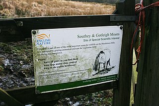
Southey and Gotleigh Moors is an 81.3 hectare biological Site of Special Scientific Interest on the Blackdown Hills in Somerset, notified in 1988.

Southlake Moor is a biological Site of Special Scientific Interest (SSSI) near Burrow Mump and Burrowbridge in Somerset, England. It was designated as an SSSI in 1985.

Tealham and Tadham Moors is a 917.6 hectare biological Site of Special Scientific Interest south of Wedmore in Somerset, notified in 1985.
West Moor is a 213.0 hectare biological Site of Special Scientific Interest on the River Parrett in Somerset, notified in 1985.

West Sedgemoor or West Sedge Moor is an area of the Somerset Levels, in Somerset, England, around 8 miles east of Taunton, which approximately coincides with the West Sedgemoor biological Site of Special Scientific Interest, a 1,016 hectare site notified as an SSSI in 1983. It is a flat, low-lying area of fields and meadows separated by water-filled rhynes and ditches. It is subject to controlled flooding in winter. It is drained by the River Parrett.

Westhay Moor is a 513.7-hectare (1,269-acre) biological Site of Special Scientific Interest 2.5 kilometres (1.6 mi) north-east of Westhay village and 4 kilometres (2.5 mi) from Wedmore in Somerset, England, notified in 1971. Westhay Moor is also notified as part of the Somerset Levels and Moors Special Protection Area under the EU Birds Directive and as a Ramsar site, and a National Nature Reserve.

Wet Moor is a 491.0-hectare biological Site of Special Scientific Interest east of Muchelney in Somerset, notified in 1985.

