
The Mendip Hills is a range of limestone hills to the south of Bristol and Bath in Somerset, England. Running from Weston-super-Mare and the Bristol Channel in the west to the Frome valley in the east, the hills overlook the Somerset Levels to the south and the Chew Valley and other tributaries of the Avon to the north. The highest point, at 325 metres above sea level, is Beacon Batch which is the summit area atop Black Down. The hills gave their name to the former local government district of Mendip, which administered most of the local area until April 2023. The higher, western part of the hills, covering 198 km2 (76 sq mi) has been designated an Area of Outstanding Natural Beauty (AONB), which gives it a level of protection comparable to a national park.

The greater horseshoe bat is an insectivorous bat of the genus Rhinolophus. Its distribution covers Europe, Northern Africa, Central Asia and Eastern Asia. It is the largest of the horseshoe bats in Europe and is thus easily distinguished from other species. The species is sedentary, typically travelling up to 30 kilometres (19 mi) between the winter and summer roosts, with the longest recorded movement being 180 km (110 mi). The frequencies used by this bat species for echolocation lie between 69–83 kHz, have most energy at 81 kHz and have an average duration of 37.4 ms.

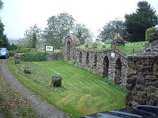
Ebbor Gorge is a limestone gorge in Somerset, England, designated and notified in 1952 as a 63.5-hectare (157-acre) biological Site of Special Scientific Interest in the Mendip Hills. It was donated to the National Trust in 1967 and is now managed by Natural England as a national nature reserve.

Somerset is a rural county in the southwest of England, covering 4,171 square kilometres (1,610 sq mi). It is bounded on the north-west by the Bristol Channel, on the north by Bristol and Gloucestershire, on the north-east by Wiltshire, on the south-east by Dorset, and on the south west and west by Devon. It has broad central plains with several ranges of low hills. The landscape divides into four main geological sections from the Silurian through the Devonian and Carboniferous to the Permian which influence the landscape, together with water-related features.

Compton Martin is a small village and civil parish within the Chew Valley in Somerset and in the Bath and North East Somerset unitary authority in England. The parish has a population of 508. It lies between Chew Valley Lake and Blagdon Lake, north of the Mendip Hills, approximately 10 miles (16 km) south of Bristol on the A368 road Weston-super-Mare to Bath, between Blagdon and West Harptree.
The Chew Valley is an affluent area in North Somerset, England, named after the River Chew, which rises at Chewton Mendip, and joins the River Avon at Keynsham. Technically, the area of the valley is bounded by the water catchment area of the Chew and its tributaries; however, the name Chew Valley is often used less formally to cover other nearby areas, for example, Blagdon Lake and its environs, which by a stricter definition are part of the Yeo Valley. The valley is an area of rich arable and dairy farmland, interspersed with a number of villages.
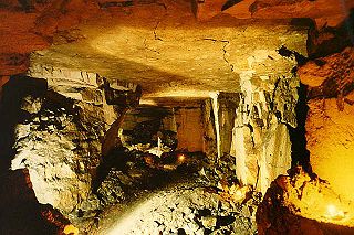
Banwell Ochre Caves are a 12.46-hectare geological Site of Special Scientific Interest near the village of Banwell, North Somerset, notified in 1983.
Banwell Caves are a 1.7-hectare geological and biological Site of Special Scientific Interest near the village of Banwell, North Somerset, England notified in 1963.
Browne's Folly, or Brown's Folly, is a folly tower sitting within a 39.9 hectare biological and geological Site of Special Scientific Interest (SSSI) near the English village of Bathford in Somerset, notified in 1974: the site itself is known as the Farleigh Down Stone Quarry and is managed as a nature reserve by the Avon Wildlife Trust (AWT). The tower was built in 1848 and is a Grade II listed building.
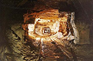
Combe Down and Bathampton Down Quarries make up a 6.22 hectare Site of Special Scientific Interest (SSSI) in Bath and North East Somerset, England, important for its bat population. The disused quarries date from the 17th and 18th centuries and were the source of Bath stone for the city of Bath and elsewhere in the UK. A five-year project to stabilise the quarry workings was largely completed by November 2009.
Emborough Quarries is a 1 hectare geological Site of Special Scientific Interest at Emborough in the Mendip Hills, Somerset, notified in 1971.

Crook Peak to Shute Shelve Hill is a 332.2 hectare (820.9 acre) geological and biological Site of Special Scientific Interest near the western end of the Mendip Hills, Somerset. The line of hills runs for approximately 5 kilometres (3.1 mi) from west to east and includes: Crook Peak, Compton Hill, Wavering Down, Cross Plain and Shute Shelve Hill. Most of the site is owned by the National Trust, which bought 725 acres (293 ha) in 1985, and much of it has been designated as common land. It was notified as an SSSI by Natural England in 1952.

Rodney Stoke is a small village and civil parish, located at grid reference ST486501, 5 miles north-west of Wells, in the English county of Somerset. The village is on the A371 between Draycott and Westbury-sub-Mendip.
The Perch is a 72.1 hectare biological Site of Special Scientific Interest close to Cheddar Gorge in the Mendip Hills, Somerset, England. It received SSSI notification in 1990.

Old Iron Works, Mells is a 0.25 hectare biological Site of Special Scientific Interest, in the Wadbury Valley, south of the village of Mells in Somerset, notified in 1987. The site is a ruined iron works, which mainly produced agricultural edge-tools that were exported all over the world, and is now, in addition to its unique and major importance in relation to industrial archaeology, used as a breeding site by horseshoe bats. The block of buildings adjacent to the entrance is listed Grade II* and most of the rest of the site is a Scheduled Ancient Monument. It is included in the Heritage at Risk Register produced by English Heritage.
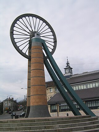
The Somerset Coalfield in northern Somerset, England is an area where coal was mined from the 15th century until 1973. It is part of a larger coalfield which stretched into southern Gloucestershire. The Somerset coalfield stretched from Cromhall in the north to the Mendip Hills in the south, and from Bath in the east to Nailsea in the west, a total area of about 240 square miles (622 km2). Most of the pits on the coalfield were concentrated in the Cam Brook, Wellow Brook and Nettlebridge Valleys and around Radstock and Farrington Gurney. The pits were grouped geographically, with clusters of pits close together working the same coal seams often under the same ownership. Many pits shared the trackways and tramways which connected them to the Somerset Coal Canal or railways for distribution.

The Mells River flows through the eastern Mendip Hills in Somerset, England. It rises at Gurney Slade and flows east joining the River Frome at Frome.

The county of Somerset is in South West England, bordered by the Bristol Channel and the counties of Bristol and Gloucestershire to the north, and Wiltshire to the east, Dorset to the south, and Devon to the west. The climate, influenced by its proximity to the Atlantic Ocean and the prevailing westerly winds, tends to be mild, damp and windy.

The River Boyd is a river of some 7 miles (11 km) in length which rises near Dodington in South Gloucestershire, England. It is a tributary of the Bristol Avon, running in a southerly direction and joining near Bitton. The flow rate at Bitton is an average 19.8 cubic feet per second (0.56 m3/s). It was immortalised in the 1613 poem by John Dennys of Pucklechurch The Secrets of Angling, the earliest English poetical tract on fishing:
And thou sweet Boyd that with thy watry sway
Dost wash the cliffes of Deington and of Weeke
And through their Rockes with crooked winding way
Thy mother Avon runnest soft to seeke
In whose fayre streames the speckled Trout doth play
The Roche the Dace the Gudgin and the Bleeke
Teach me the skill with slender Line and Hooke
To take each Fish of River Pond and Brooke.
The Bath and Bradford-on-Avon Bats SAC is a Special Area of Conservation originally designated under the European Union's Habitats Directive (92/43/EEC), also known as the Directive on the Conservation of Natural Habitats and of Wild Fauna and Flora.

