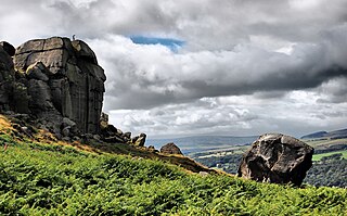
Ilkley Moor is part of Rombalds Moor, the moorland between Ilkley and Keighley in West Yorkshire, England. The moor, which rises to 402 m (1,319 ft) above sea level, is well known as the inspiration for the Yorkshire "county anthem" On Ilkla Moor Baht 'at.

Penlee Point is a promontory near the coastal fishing village of Mousehole in west Cornwall, England, UK. It was the launching point of the Penlee lifeboat, which was lost in the disaster of 1981.

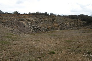
Chilmark Quarries is a 9.65 hectare biological and geological Site of Special Scientific Interest (SSSI), in the ravine south of the village of Chilmark in Wiltshire, England.
Veizey's Quarry is a 1.4 hectare geological Site of Special Scientific Interest near Tetbury in Gloucestershire, notified in 1974. It is in the Cotswold Area of Outstanding Natural Beauty. The site is listed in the 'Cotswold District' Local Plan 2001-2011 as a Key Wildlife Site (KWS) and a Regionally Important Geological Site (RIGS).

Coaley Wood Quarries is a 4.85-hectare (12.0-acre) geological Site of Special Scientific Interest in Gloucestershire, notified in 1974.
Easter Park Farm Quarry is a 0.15-hectare (0.37-acre) geological Site of Special Scientific Interest in Gloucestershire, notified in 1986. The site is listed in the ‘Stroud District’ Local Plan, adopted November 2005, Appendix 6 as an SSSI and a Regionally Important Geological Site (RIGS).
Foss Cross Quarry is a 0.67-hectare (1.7-acre) geological Site of Special Scientific Interest in Gloucestershire, notified in 1972. The site is listed in the 'Cotswold District' Local Plan 2001-2011 as a Key Wildlife Site (KWS) and a Regionally Important Geological Site (RIGS).
Hornsleasow Quarry is a 3.5-hectare (8.6-acre) geological Site of Special Scientific Interest in Gloucestershire, notified in 1974. The site is listed in the 'Cotswold District' Local Plan 2001-2011 as a Regionally Important Geological Site (RIGS).
Land Grove Quarry, Mitcheldean is a 3.8-hectare (9.4-acre) geological Site of Special Scientific Interest in Gloucestershire, England, notified in 1974. The site is listed in the 'Forest of Dean Local Plan Review' as a Key Wildlife Site (KWS).

Hay-a-Park Gravel Pit is a Site of Special Scientific Interest, or SSSI, adjacent to the east side of the town of Knaresborough, North Yorkshire, England. Having been a disused and flooded quarry since the 1970s, it now consists of the large Hay-a-Park Lake and three smaller ponds, besides associated reedbeds, scrub, woodland and grassland. It was designated as a SSSI in 1995 because it supports a number of wintering birds, including a large flock of goosander. This site is "one of the most northerly inland breeding populations of reed warbler in Britain." Hay-a-Park was once part of a royal park, an early landowner being Edward II.

Quarry Moor is a Site of Special Scientific Interest, or SSSI, at the south edge of Ripon, North Yorkshire, England, and adjacent to the A61 road. It contains an outcrop of Magnesian Limestone, exposed by former quarrying. 255 million years ago this limestone was the peripheral sediment of a tropical sea. The land was donated in 1945 to the people of Ripon by the town's mayor, Alderman Thomas Fowler Spence, a varnish manufacturer. The land was notified as an SSSI in 1986 because its calcareous grassland supported a large diversity of plant species. The site features a Schedule 8 protected plant, thistle broomrape. The land is protected as a nature reserve, and it is also managed as a recreational area. Therefore, its calcareous grass area is fenced off for protection and study, but it also contains a car park, information signs, a children's play area, accessible paths, benches, and dog waste bins.

Mar Field Fen is a Site of Special Scientific Interest, or SSSI, north of Masham, North Yorkshire, England, in a rural area known as Marfield. It is situated on land containing woodland carr, fen, spring-fed marshy grassland and drier calcareous grassland, between the River Ure to the east and Marfield Wetland nature reserve to the west. As "one of the best examples of fen habitat in the Vale of York," it is a protected habitat for a variety of plants, including the common butterwort, a carnivorous plant. There is no public access to this site.


