Clevedon Shore

Last updated
Clevedon Shore
Site of Special Scientific Interest
Clevedon Shore.jpg
Somerset UK location map.svg
Red pog.svg
Location within Somerset
Area of Search North Somerset
Grid reference ST402719
Coordinates 51°26′35″N2°51′43″W / 51.44292°N 2.86181°W / 51.44292; -2.86181 Coordinates: 51°26′35″N2°51′43″W / 51.44292°N 2.86181°W / 51.44292; -2.86181
Interest Geological
Area 0.94 acres (0.0038 km2; 0.00147 sq mi)
Notification 1991 (1991)
Natural England website

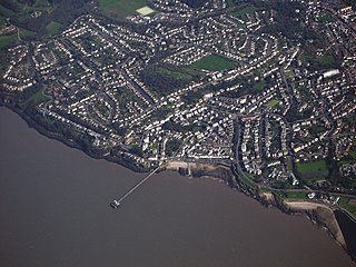
Clevedon Shore (grid reference ST402719 ) is a 0.38 hectare geological Site of Special Scientific Interest adjacent to the Severn Estuary at Clevedon, North Somerset, notified in 1991.

Ordnance Survey National Grid System of geographic grid references used in Great Britain

The Ordnance Survey National Grid reference system is a system of geographic grid references used in Great Britain, distinct from latitude and longitude. It is often called British National Grid (BNG).

Hectare metric unit of area

The hectare is an SI accepted metric system unit of area equal to a square with 100-metre sides, or 10,000 m2, and is primarily used in the measurement of land. There are 100 hectares in one square kilometre. An acre is about 0.405 hectare and one hectare contains about 2.47 acres.

Severn Estuary the estuary of the River Severn, the longest river in Great Britain; mouth of the Severn, Wye, Usk, and the Bristol Avon

The Severn Estuary is the estuary of the River Severn, the longest river in Great Britain. It is the confluence of four major rivers, being the Severn, Wye, Usk and Avon, and other smaller rivers. Its high tidal range, approximately 50 feet (15 m), means that it has been at the centre of discussions in the UK regarding renewable energy.

It is the side of a mineralised fault, which runs east-west adjacent to the pier, and forms a small cliff feature in Dolomitic Conglomerate on the north side of Clevedon Beach, containing cream to pink baryte together with sulphides. The minerals identified at the site include: haematite, chalcopyrite, tennantite, galena, tetrahedrite, bornite, pyrite, marcasite, enargite and sphalerite. Secondary alteration of this assemblage has produced idaite, Covellite and other Copper sulphides. [1]

Conglomerate (geology) A coarse-grained clastic sedimentary rock with mainly rounded to subangular clasts

Conglomerate is a coarse-grained clastic sedimentary rock that is composed of a substantial fraction of rounded to subangular gravel-size clasts, e.g., granules, pebbles, cobbles, and boulders, larger than 2 mm (0.079 in) in diameter. Conglomerates form by the consolidation and lithification of gravel. Conglomerates typically contain finer grained sediment, e.g., either sand, silt, clay or combination of them, called matrix by geologists, filling their interstices and are often cemented by calcium carbonate, iron oxide, silica, or hardened clay.
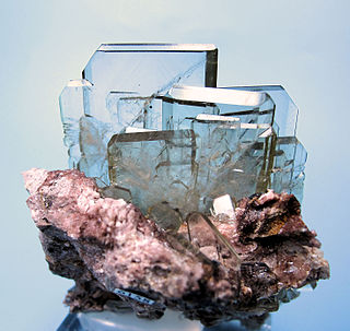
Baryte sulfate mineral

Baryte or barite (, ) is a mineral consisting of barium sulfate (BaSO4). Baryte is generally white or colorless, and is the main source of barium. The baryte group consists of baryte, celestine (strontium sulfate), anglesite (lead sulfate), and anhydrite (calcium sulfate). Baryte and celestine form a solid solution (Ba,Sr)SO4.

Chalcopyrite sulfide mineral

Chalcopyrite ( KAL-ko-PY-ryt) is a copper iron sulfide mineral that crystallizes in the tetragonal system. It has the chemical formula CuFeS2. It has a brassy to golden yellow color and a hardness of 3.5 to 4 on the Mohs scale. Its streak is diagnostic as green tinged black.

The site is listed as a Geological Conservation Review site as several of the minerals found here are rare, in particular the beudantite. The presence of copper and arsenic is unusual for the Mendip district.

The Geological Conservation Review (GCR) is produced by the UK's Joint Nature Conservation Committee and is designed to identify those sites of national and international importance needed to show all the key scientific elements of the geological and geomorphological features of Britain. These sites display sediments, rocks, minerals, fossils, and features of the landscape that make a special contribution to an understanding and appreciation of Earth science and the geological history of Britain, which stretches back more than three billion years. The intention of the project, which was devised in 1974 by George Black and William Wimbledon working for the Governmental advisory agency, the Nature Conservancy Council (NCC), was activated in 1977. It aimed to provide the scientific rationale and information base for the conservation of geological SSSIs (Sites of Special Scientific Interest, protected under British law. The NCC and country conservation agencies were established in 1990 when JNCC became established and took over responsibility for managing the GCR site assessment process, and publishing accounts of accepted sites.

Beudantite alunite supergroup, arsenate-sulfate mineral

Beudandite is a secondary mineral occurring in the oxidized zones of polymetallic deposits. It is a lead, iron, arsenate, sulfate with endmember formula: PbFe3(OH)6SO4AsO4.

Copper Chemical element with atomic number 29

Copper is a chemical element with symbol Cu and atomic number 29. It is a soft, malleable, and ductile metal with very high thermal and electrical conductivity. A freshly exposed surface of pure copper has a pinkish-orange color. Copper is used as a conductor of heat and electricity, as a building material, and as a constituent of various metal alloys, such as sterling silver used in jewelry, cupronickel used to make marine hardware and coins, and constantan used in strain gauges and thermocouples for temperature measurement.

Related Research Articles

Pentlandite sulfide mineral

Pentlandite is an iron-nickel sulfide, (Fe,Ni)9S8. Pentlandite has a narrow variation range in Ni:Fe but it is usually described as having a Ni:Fe of 1:1. It also contains minor cobalt, usually at low levels as a fraction of weight.

Rammelsberg Mine and mining museum in the Harz

The Rammelsberg is a mountain, 635 metres (2,083 ft) high, on the northern edge of the Harz range, south of the historic town of Goslar in the North German state of Lower Saxony. The mountain is the location of an important silver, copper, and lead mine, the only mine which had been working continuously for over 1,000 years when it finally closed in 1988. Since 1992, the visitor mine of Rammelsberg has become a UNESCO World heritage site.

Clevedon town and civil parish in North Somerset, England

Clevedon is a town and civil parish in the unitary authority of North Somerset, which covers part of the ceremonial county of Somerset, England. It has a population of 21,281 according to the United Kingdom Census 2011. It lies among a group of small hills, including Church Hill, Wain's Hill, Dial Hill, Strawberry Hill, Castle Hill, Hangstone Hill and Court Hill which is a Site of Special Scientific Interest along the Severn estuary. Though mentioned in the Domesday Book, Clevedon grew in the Victorian period as a seaside resort and in the 20th century as a dormitory town.

The platinum-group metals are six noble, precious metallic elements clustered together in the periodic table. These elements are all transition metals in the d-block.

Covellite sulfide mineral

Covellite is a rare copper sulfide mineral with the formula CuS. This indigo blue mineral is ubiquitous in copper ores, it is found in limited abundance and is not an important ore of copper itself, although it is well known to mineral collectors.

Clevedon Pier Grade I listed pier in North Somerset, United Kingdom

Clevedon Pier is a seaside pier in the town of Clevedon, Somerset, England on the east shore of the Severn Estuary. It has been described by Sir John Betjeman, as "the most beautiful pier in England" and was designated a Grade I listed building in 2001.

Exploration geophysics is an applied branch of geophysics and economic geology, which uses physical methods, such as seismic, gravitational, magnetic, electrical and electromagnetic at the surface of the Earth to measure the physical properties of the subsurface, along with the anomalies in those properties. It is most often used to detect or infer the presence and position of economically useful geological deposits, such as ore minerals; fossil fuels and other hydrocarbons; geothermal reservoirs; and groundwater reservoirs.

Court Hill

Court Hill is a 10.45 hectare geological Site of Special Scientific Interest near the town of Clevedon, North Somerset, England; notified in 1997.

Violarite (Fe2+Ni23+S4) is a supergene sulfide mineral associated with the weathering and oxidation of primary pentlandite nickel sulfide ore minerals.

Polymetallic replacement deposit

A polymetallic replacement deposit is an orebody of metallic minerals formed by the replacement of sedimentary, usually carbonate rock, by metal-bearing solutions in the vicinity of igneous intrusions. When the ore forms a blanketlike body along the bedding plane of the rock, it is commonly called a manto ore deposit. Other ore geometries are chimneys and veins. Polymetallic replacements/mantos are often stratiform wall-rock replacement orebodies distal to porphyry copper deposits. The term manto is from the Spanish word for mantle, or cloak, although the geologic manto is more like a mantle roll than a sheetlike structure.

Kanichee Mine

The Kanichee Mine, also less commonly known as the Ajax Mine, is an abandoned base metal and precious metal mine, located in the Temagami region of northeastern Ontario, Canada. It is near the small unincorporated community of Temagami North, accessed by the Kanichee Mine Road from Highway 11. The Kanichee Mine zone has been explored and mined discontinuously from as early as 1910. During the 20th century, it operated and closed down at least three times, with the most recent being from 1973 to 1976. To date, the discontinuous operation of Kanichee Mine has produced 4.2 million pounds of metal.

Uranium mining in Colorado

Uranium mining in Colorado, United States, goes back to 1872, when pitchblende ore was taken from gold mines near Central City, Colorado. The Colorado uranium industry has seen booms and busts, but continues to this day. Not counting byproduct uranium from phosphate, Colorado is considered to have the third largest uranium reserves of any US state, behind Wyoming and New Mexico.

Whim Creek Copper Mine

The Whim Creek Copper Mine is an operating copper oxide mine, located in the Pilbara region of Western Australia.

Elizabeth Mine

The Elizabeth Mine was a copper mine located on the town line between the Town of Strafford and the Town of Thetford, in Orange County, Vermont.

Mining in the United Kingdom

Mining in the United Kingdom produces a wide variety of fossil fuels, metals, and industrial minerals due to its complex geology. In 2013, there were over 2,000 active mines, quarries, and offshore drilling sites on the continental land mass of the United Kingdom producing £34bn of minerals and employing 36,000 people.

The Bathurst Mining Camp is a mining district in northeast New Brunswick, Canada, centred in the Nepisiguit River valley, and near to Bathurst. The camp hosts 45 known volcanogenic massive sulfide (VMS) deposits typical of the Appalachian Mountains. Some of the ore is smelted at the Belledune facility of Xstrata. Although the primary commodity is zinc, the massive-sulphide ore body produces lead, zinc, copper, silver, gold, bismuth, antimony and cadmium.

The San Manuel Copper Mine was a surface and underground porphyry copper mine located in San Manuel, Pinal County, Arizona. Frank Schultz was the original discoverer, in 1879, but the main body of the deposits were discovered by Henry W. Nichols in 1942. The exploration drilling went on from 1943 to 1948, with the first mine shaft built 1948. Louis Lesser developed a mining city to service Nichols’ newly discovered deposits, and the development was completed about 1954. The first major production began in 1955, and the mine and smelter were permanently closed in 2003.

Nautilus Minerals an underwater mineral exploration company headquartered in Toronto, Canada

Nautilus Minerals Inc. is an underwater mineral exploration company headquartered in Toronto, Ontario, Canada. It is the first company to commercially explore the seafloor for massive sulfide systems, a potential source of high grade copper, gold, zinc and silver.

The Aktogay mine is a large open-pit mine located in south eastern Kazakhstan in East Kazakhstan Province approximately 250 km from Kazakhstan - China border. Aktogay is KAZ Minerals's second major growth project.

Geology of Namibia

The geology of Namibia encompasses rocks of Paleoproterozoic, Mesoproterozoic and Neoproterozoic and Paleozoic to Cenozoic age. About 46% of the countryʼs surface are bedrock exposure, while the remainder is covered by the young overburden sediments of the Kalahari and Namib deserts.

References