
A volcano is a rupture in the crust of a planetary-mass object, such as Earth, that allows hot lava, volcanic ash, and gases to escape from a magma chamber below the surface.

Mount St. Helens is an active stratovolcano located in Skamania County, Washington in the Pacific Northwest region of the United States. It lies 52 miles (83 km) northeast of Portland, Oregon and 98 miles (158 km) south of Seattle. Mount St. Helens takes its English name from the British diplomat Lord St Helens, a friend of explorer George Vancouver who surveyed the area in the late 18th century. The volcano is part of the Cascade Volcanic Arc, a segment of the Pacific Ring of Fire.

A stratovolcano, also known as a composite volcano, is a conical volcano built up by many layers (strata) of hardened lava and tephra. Unlike shield volcanoes, stratovolcanoes are characterized by a steep profile with a summit crater and periodic intervals of explosive eruptions and effusive eruptions, although some have collapsed summit craters called calderas. The lava flowing from stratovolcanoes typically cools and hardens before spreading far, due to high viscosity. The magma forming this lava is often felsic, having high-to-intermediate levels of silica, with lesser amounts of less-viscous mafic magma. Extensive felsic lava flows are uncommon, but have travelled as far as 15 km (9.3 mi).
Lava Beds National Monument is located in northeastern California, in Siskiyou and Modoc counties. The monument lies on the northeastern flank of Medicine Lake Volcano and has the largest total area covered by a volcano in the Cascade Range.

A shield volcano is a type of volcano named for its low profile, resembling a warrior's shield lying on the ground. It is formed by the eruption of highly fluid lava, which travels farther and forms thinner flows than the more viscous lava erupted from a stratovolcano. Repeated eruptions result in the steady accumulation of broad sheets of lava, building up the shield volcano's distinctive form.

Lassen Volcanic National Park is an American national park in northeastern California. The dominant feature of the park is Lassen Peak, the largest plug dome volcano in the world and the southernmost volcano in the Cascade Range. Lassen Volcanic National Park is one of the few areas in the world where all four types of volcano can be found—plug dome, shield, cinder cone, and stratovolcano.

The geology of the Lassen volcanic area presents a record of sedimentation and volcanic activity in the area in and around Lassen Volcanic National Park in Northern California, U.S. The park is located in the southernmost part of the Cascade Mountain Range in the Pacific Northwest region of the United States. Pacific Oceanic tectonic plates have plunged below the North American Plate in this part of North America for hundreds of millions of years. Heat from these subducting plates has fed scores of volcanoes in California, Oregon, Washington and British Columbia over at least the past 30 million years and is also responsible for activities in the Lassen volcanic area.

Kīlauea is an active shield volcano in the Hawaiian Islands. Historically, it is the most active of the five volcanoes that together form the Big Island of Hawaiʻi. Located along the southeastern shore of the island, the volcano is between 210,000 and 280,000 years old and emerged above sea level about 100,000 years ago. Its most recent eruption began on December 20, 2020 and ended on May 23, 2021.

The Vredefort crater is the largest verified impact crater on Earth. It was 160–300 km (99–186 mi) across when it was formed; what remains of it is in the present-day Free State province of South Africa. It is named after the town of Vredefort, which is near its centre. Although the crater itself has long since been eroded away, the remaining geological structures at its centre are known as the Vredefort Dome or Vredefort impact structure. The crater is calculated to be 2.023 billion years old, with impact being in the Paleoproterozoic Era. It is the second-oldest known crater on Earth, after Yarrabubba crater.

Mount St. Helens National Volcanic Monument is a U.S. National Monument that includes the area around Mount St. Helens in Washington. It was established on August 27, 1982 by U.S. President Ronald Reagan following the 1980 eruption. The 110,000 acre (445 km2) National Volcanic Monument was set aside for research, recreation, and education. Inside the Monument, the environment is left to respond naturally to the disturbance.

La Garita Caldera is a large supervolcanic caldera in the San Juan volcanic field in the San Juan Mountains near the town of Creede in southwestern Colorado, United States. It is west of La Garita, Colorado. The eruption that created the La Garita Caldera is among the largest known volcanic eruptions in Earth's history, as well as being one of the most powerful known supervolcanic events.

A fissure vent, also known as a volcanic fissure, eruption fissure or simply a fissure, is a linear volcanic vent through which lava erupts, usually without any explosive activity. The vent is often a few metres wide and may be many kilometres long. Fissure vents can cause large flood basalts which run first in lava channels and later in lava tubes. After some time the eruption builds up spatter cones and may concentrate on one or some of them. Small fissure vents may not be easily discernible from the air, but the crater rows or the canyons built up by some of them are.

The Cascade Volcanoes are a number of volcanoes in a volcanic arc in western North America, extending from southwestern British Columbia through Washington and Oregon to Northern California, a distance of well over 700 miles (1,100 km). The arc formed due to subduction along the Cascadia subduction zone. Although taking its name from the Cascade Range, this term is a geologic grouping rather than a geographic one, and the Cascade Volcanoes extend north into the Coast Mountains, past the Fraser River which is the northward limit of the Cascade Range proper.

Several types of volcanic eruptions—during which lava, tephra, and assorted gases are expelled from a volcanic vent or fissure—have been distinguished by volcanologists. These are often named after famous volcanoes where that type of behavior has been observed. Some volcanoes may exhibit only one characteristic type of eruption during a period of activity, while others may display an entire sequence of types all in one eruptive series.
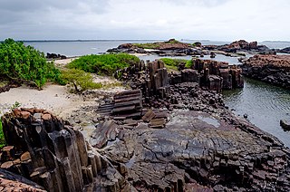
St. Mary's Islands, also known as Coconut Island and Thonsepar, are a set of four small islands in the Arabian Sea off the coast of Malpe in Udupi, Karnataka, India. They are known for their distinctive geological formation of columnar rhyolitic lava (pictured).

The Athabasca Valles are a late Amazonian-period outflow channel system in the central Elysium Planitia region of Mars, located to the south of the Elysium Rise. They are part of a network of outflow channels in this region that are understood to emanate from large fissures in the Martian surface rather than the chaos terrains that source the circum-Chryse outflow channels. The Athabasca Valles in particular emanate from one of the Cerberus Fossae fissures and flow downstream to the southwest, constrained to the south by a wrinkle ridge for over 100 km, before debouching into the Cerberus Palus volcanic plain. The Athabasca Valles are widely understood to be the youngest outflow channel system on the planet.

A lava cave is any cave formed in volcanic rock, though it typically means caves formed by volcanic processes, which are more properly termed volcanic caves. Sea caves, and other sorts of erosional and crevice caves, may be formed in volcanic rocks, but through non-volcanic processes and usually long after the volcanic rock was emplaced.

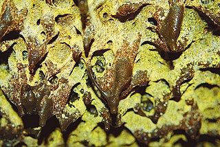
Lava is magma once it has been expelled from the interior of a terrestrial planet or a moon onto its surface. Lava may be erupted at a volcano or through a fracture in the crust, on land or undersea, usually at temperatures from 800 to 1,200 °C. The volcanic rock resulting from subsequent cooling is also often called lava.

Benham Falls are rapids of the Deschutes River located between Sunriver and Bend, Oregon, United States. With a pitch of 22.5°, they are rated Class 5 for watercraft, and are the largest falls on the upper Deschutes.

Martian lava tubes are volcanic caverns on Mars that are believed to form as a result of fast-moving, basaltic lava flows associated with shield volcanism. Lava tubes usually form when the external surface of the lava channels cools more quickly and forms a hardened crust over subsurface lava flows. The flow eventually ceases and drains out of the tube, leaving a conduit-shaped void space which is usually several meters below the surface. Lava tubes are typically associated with extremely fluid pahoehoe lava. Gravity on mars is about 38% that of Earth's, allowing Martian lava tubes to be much larger in comparison.

